
This item below is out of stock, but another example (left) is available. To view the available item, click "Details."
Details
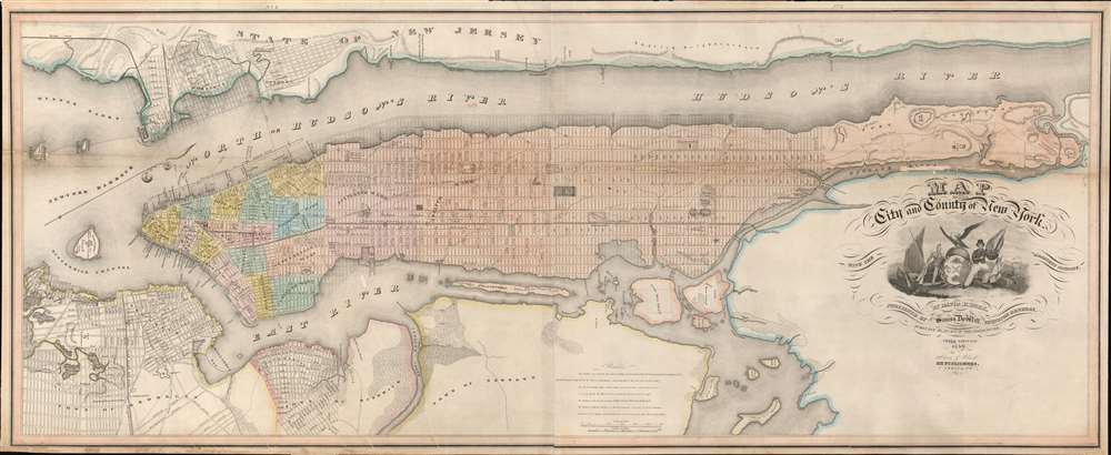
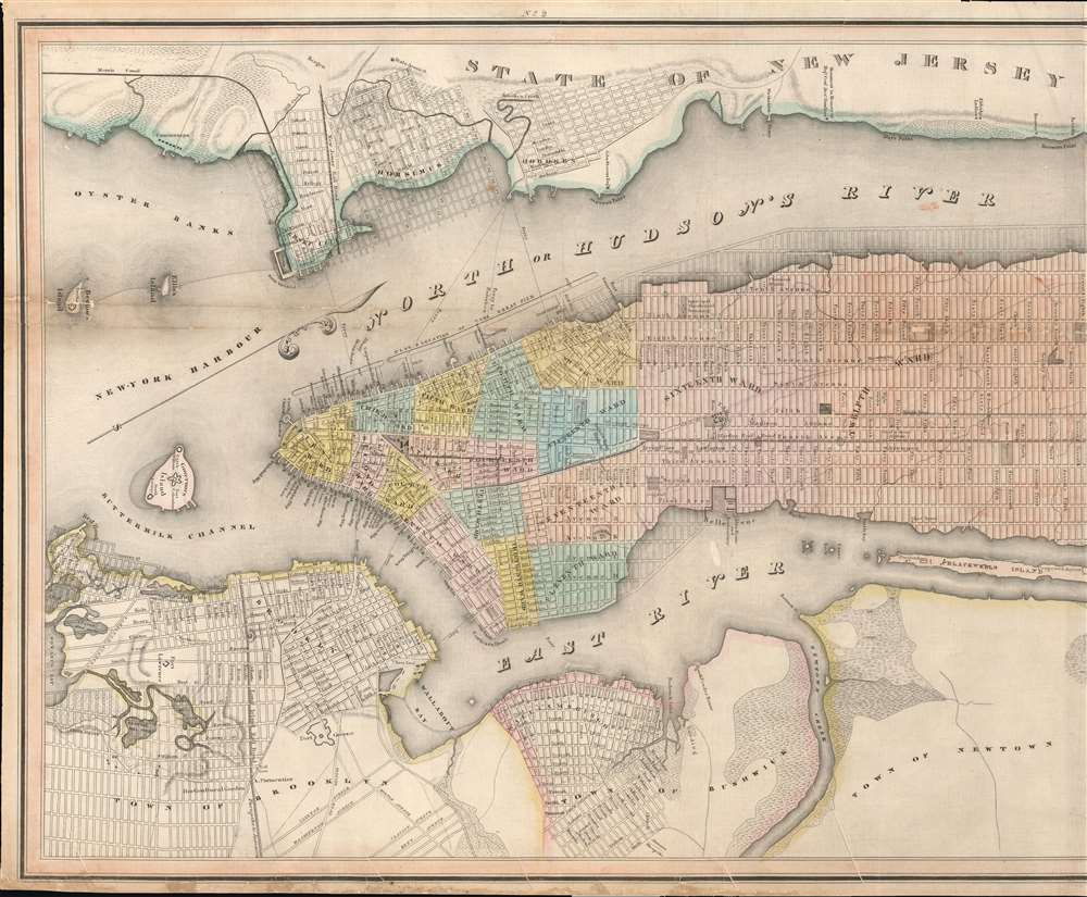
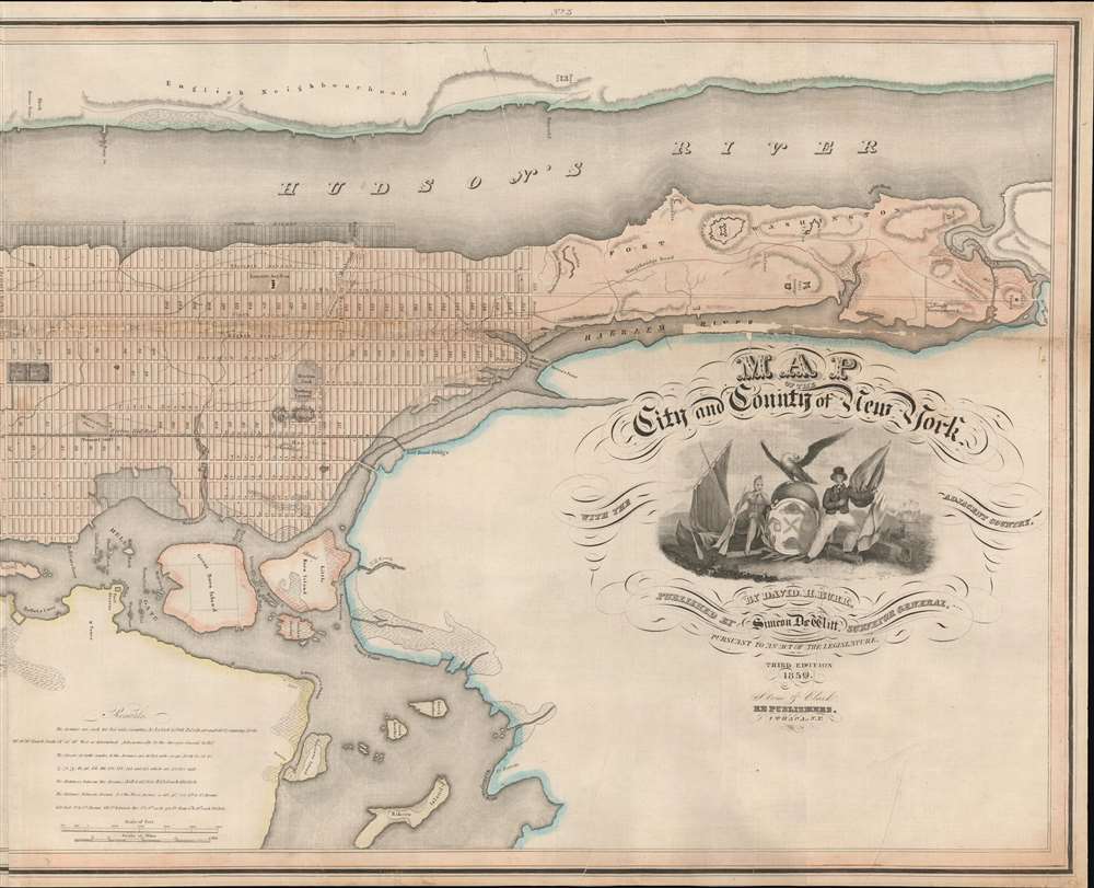
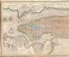
1840 Burr Map of Manhattan, New York City
1840 (dated) $6,500.00
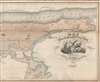
1839 Burr Map of Manhattan, New York City
NewYork-burr-1839$4,250.00

Title
Map of the City and County of New York, with the adjacent country.
1839 (dated) 21 x 50.5 in (53.34 x 128.27 cm) 1 : 20000
1839 (dated) 21 x 50.5 in (53.34 x 128.27 cm) 1 : 20000
Description
This is an example of David Burr's rare 1839 map of Manhattan, New York City. Burr's map is one of the earliest maps focused specifically on Manhattan to illustrate the entire island. Oriented to the northeast, the map roughly follows the layout and design of the 1811 Commissioner's Plan, wherein the geography of the island is sublimated by the city's iconic street grid. Burr's more commercial map also extends the coverage further east and west, to accommodate, Brooklyn, Bushwick, Williamsburg, Hoboken, and Jersey City.
Publication History and Census
This map was engraved by David Burr and first published by Simeon DeWitt in 1829-1930 as a foldout in Burr's Atlas of the State of New York, only the second state atlas ever published. There were several subsequent editions and separate issues. The present example, dated to 1839, is the third edition published in Ithaca, New York, by Stone and Clark. Later, the plates were acquired by Joseph Hutchins Colton (1800 - 1893), who used them as the basis for his own important map of New York City. In the 1860s, this map further served as the baseline template for the 1864 Viele Map. While well represented institutionally, all examples are rare to the market.CartographerS
David Hugh Burr (August 18, 1803 - December 25, 1875) of one of the first and most important truly American cartographers and map publishers. Burr was born in Bridgeport Connecticut in August of 1803. In 1822 Burr moved to Kingsboro, New York to study law. A year and a half later he was admitted to the New York Bar association. Burr must have questioned his choice of careers because shortly after being admitted to the Bar, he joined the New York State Militia. Though largely untrained in the art of surveying, Burr was assigned to work under Surveyor General of New York, Simeon De Witt, to survey several New York Roadways. Seeing a window of opportunity, Burr was able to negotiate with the governor of New York at the time, De Witt Clinton, to obtain copies of other New York survey work in order to compile a map and Atlas of the state of New York. Recognizing the need for quality survey work of its territory, the government of New York heartily endorsed and financed Burr's efforts. The resulting 1829 Atlas of the State of New York was the second atlas of an individual U.S. state and one of the most important state atlases ever produced. Burr went on to issue other maps both of New York and of the United States in general. In cooperation with publishing firm of Illman & Pillbrow, he produced an important New Universal Atlas and, with J.H. Colton, several very important maps of New York City. In recognition of this work, Burr was appointed both "Topographer to the Post office" and "Geographer to the House of Representatives of the United States". Later, in 1855, Burr was assigned to the newly created position of Surveyor General to the State of Utah. Burr retired from the position and from cartographic work in general in 1857 when light of some of his financial misdeeds and frauds came to light. He was accused of submitting false expense reports and underpaying employees, among other indiscretions. More by this mapmaker...
Simeon De Witt (December 25, 1756 - December 3, 1834) was an American geographer, surveyor, publisher, and politician based in New York during the late 18th and early 19th centuries. De Witt was born in Wawarsing, Ulster County, New York, the son of the well-educated physician Dr. Andries De Witt and wife Jannetje Vernooy De Witt, both of Dutch ancestry. He graded in 1776 from Queens College (Rutgers). During the American Revolutionary War (1775 - 1783) he volunteered for the Continental Army in New York City. He trained as a surveyor under his uncle James Clinton (1736 - 1812), and was thus commissioned as the assistant of Geographer and Surveyor of the Army, Colonel Robert Erskine (1735 - 1780). When Erskine died in 1780, De Witt took over his position. His cartographic work played a significant role in the successes of the Continental Army during the war. After the war, he pushed for various national mapping projects - all of which were rejected by the Continental Congress as too expensive and ambitious. He became the New York State Surveyor General in 1784, a position he held until his death, nearly 50 years later. He was a friend to George Washington, who described De Witt in a letter to Thomas Jefferson as, 'extremely modest, sensible, sober, discreet, and deserving of favors. He is esteemed a very good mathematician.' He was part of the 3-man 1807 - 1811 Commission tasked with laying out the iconic street grid of New York City - the Commissioner's Plan. De Witt also designed the street grids for his hometown of Albany and Ithaca. From 1829 until his death in 1834, De Witt was also Chancellor of the University of the State of New York. In addition, he is given credit for the Classical Greek and Roman names to the twenty-eight central New York Military Tract townships that his office mapped after the Revolutionary War, to be given to veterans in payment for their military service - however, it is likely that the unusual toponomy was the fancy of De Witt's assistant, the avid classicist Robert Harpur (1731 - 1825). De Witt was the cousin of DeWitt-Clinton, New York governor. He died in 1834 in Ithaca of the common cold. Learn More...
Stone and Clark (fl. c. 1828 - 1855) was a publishing, engraving, and lithography firm based in Ithaca, New York. Very little of substance is known about the firm. The well known lithographer and painter, Henry Walton (1820 - 1873), worked for the firm from around 1836 until he moved to California in 1851. An advertisement in the September 11, 1839, edition of the Ithaca Chronicle placed by Stone and Clark reads that they, 'execute job work of any description, steel, copper-plate and wood engraving, letter press printing and book binding.' Around 1839 they acquired the printing rights to David Hugh Burr's (1803 - 1875) Atlas of the State of New York, which they published in at least two editions (1839 and 1840). Learn More...
Condition
Good. Laid on older linen. Two panels, joined by publisher at center. Some wear, damage, and infill along horizontal between 8th and 9th avenues. Loss in Harlem River.
References
Rumsey 0103.002. New York Public Library, Map Div. +++ 02-229. Haskell, D., Manhattan Maps A Co-operative List, 721. Harvard University, HOLLIS 990092809390203941. OCLC 48914436.