This item has been sold, but you can get on the Waitlist to be notified if another example becomes available, or purchase a digital scan.
1773 Tiddeman Map of New York City and Harbor
NewYork-tiddeman-1773$1,750.00

Title
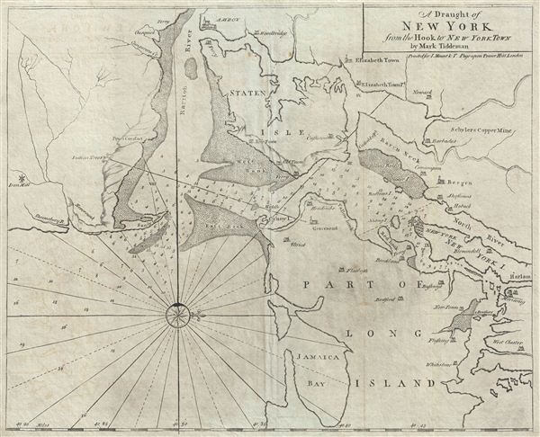
A Draught of New York from the Hook to New York Town.
1773 (undated) 17.75 x 22 in (45.085 x 55.88 cm)
1773 (undated) 17.75 x 22 in (45.085 x 55.88 cm)
Description
A scarce and impressive colonial period c. 1773 Mark Tiddeman nautical chart of New York City and harbor. Oriented to the west and centered on Coney Island (Cunny I.), Tiddeman's chart coves from Staten Island to Jamaica Bay and from Sandy Hook to Harlem (northern Manhattan). There is a compass rose in the lower left quadrant. Relief, towns, and mills are represented pictorially. Numerous depth soundings fill the harbor and sand banks are rendered with stippling. Some twenty-seven cities and villages are identified, often with quaint spellings of still common place names: Brockland (Brooklyn), Hobuck (Hoboken), Blomindoll (Bloomingdale), West Chester (Westchester), and Bushwyk (Bushwick), to name few. The map also identifies various mines and mills, including Schyler's Copper Mine in modern day North Arlington New Jersey, and an Iron Mill south of Sandy Hook.
This unusual chart was first issued in the 1732 edition of the english Pilot, the present example being the third state, marked by additional stippling, hachuring, and minor adjustments to the imprint. The map's parent publication, book four of the english Pilot, was one of the most influential collections of nautical charts ever published. Form the first printing in 1732, the english Pilot appeared in some 37 editions over the next century, remaining popular even after much of its contents became outdated and better charts, such as those contained within Sayer and Bennett's North American Pilot and Des Barres' Atlantic Neptune became available.
This chart is impressive for its inaccuracy and rather vague rendering of the region, which its itself indicative of the relatively limited hydrographic knowledge of the region in the early and middle parts of the 18th century. Augustyn and Cohen, in Manhattan in Maps, note that Tiddeman's map was better than most of its contemporaries, however, ' makes the entrance to the Lower Bay of New York Harbor appear to be less of a challenge than it really is.' The entrance to New York Harbor was, in fact, quite challenging due to the narrow entrance between Sandy Hook and east Bank followed a the critical sharp turn to starboard required to alight in New York. Until truly accurate nautical charts appeared in the early days of the U.S. Coast Survey and the entrance was widened in the 1890s, shipwrecks in this area were common - it is not inconceivable that this popular chart may have been partially responsible for at least some of them.
Published by Mount and Page of Tower Hill, London, for the c. 1773 issue of the english Pilot, book four.
CartographerS
Mark Tiddeman (fl. c. 1724 - c. 1760) was a British navigator, surveyor, chartmaker, and hydrographer active in the early 18th century. Tiddeman was sailing master of the English ship Tartar. From 1724 to 1728 he completed a hydrographic survey of New York Harbor and the mouth of the Chesapeake. These surveys were eventually adopted by Mount and Page for inclusion in the 1732 fourth book of the English Pilot. On returning to England Tiddeman completed several surveys of the Highlands of Scotland for Admiral Wagner, who was then stationed on the Coast of Scotland. On March 27th of 1741 he was commissioned as a Lieutenant in the Royal Navy. He later became a Captain and piloted several ships to and from the British West Indies. More by this mapmaker...
Mount and Page (fl. 1701 - 1760) was a London based firm of religious and maritime publishers that flourished in the 18th century. With the publication of the 1732 English Pilot, the Mount and Page name became well-known worldwide as an imprint of nautical charts. The firm was founded at Tower Hill, London, in 1701 by Richard Mount (1654 - 1722) and his apprentice Thomas Page (1780 - March 15, 1733). Mount had previously been in partnership with his father-in-law William Fisher (1631 - 1691) and inherited the business on the latter's death. Page completed his apprenticeship in 1716. Now fully partnered, Mount and Page subsequently acquired the map plates several defunct British nautical chart publishers, including Greenville Collins, Jeremiah Seller, Charles Price, and John and Samuel Thornton - thus nearly monopolizing the British nautical chart business. The firm consequently received several lucrative government contracts and thereby flourished throughout the 18th century, making the fortunes of both families. Successive generations of Mounts and Pages worked in the business, and the families intermarried. Its staple titles were The English Pilot and Navigatio Britannica by John Barrow. By the 1760s, Richard Mount's grandson John Mount (1725 - 1786) was able to retire to Berkshire where he built the stately mansion, Wasing Place. John's son William (1753 - 1815) was the last to work in the map business, and later generations went into politics. Learn More...
Source
The English Pilot. Fourth Book, (London) c. 1773.
Condition
Very good. Even overall toning. Original centerfold exhibits slight wear. Some edge wear to outer margins. Blank on verso.
References
Augustyn, R. and Cohen, P., Manhattan in Maps, pp. 66-67. Haskell, D., Manhattan Maps: A Co-operative List, #254-256. Sellers, John R. and Van Ee, Patricia, Maps and Charts of North America, #1220. Verner, C., A Carto-Bibliographical Study of The English Pilot The Fourth Book, pp.65-68. Philipps (Atlases), 1162. New York Public Library, Map Division, Map Div. 89-5007. Meinig, D. W., The Shaping of America, A Geographical Perspective on 500 Years of Histroy, pl. 23, page 120.