This item has been sold, but you can get on the Waitlist to be notified if another example becomes available, or purchase a digital scan.
1867 Colton Pocket Map of New York City and Brooklyn
NewYorkCity-colton-1867$750.00

Title
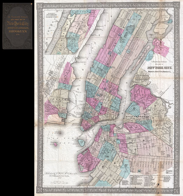
G. Woolworth Colton's New Map of New York City, Brooklyn, Jersey City, Hoboken, Etc.
1867 (dated) 24 x 18.5 in (60.96 x 46.99 cm)
1867 (dated) 24 x 18.5 in (60.96 x 46.99 cm)
Description
An extremely rare example of G. Woolworth Colton's 1867 vertical pocket map of New York. This important map, first issued in 1865, marks a significant rethinking of the standard Manhattan map. Previous maps of New York City tended to represent only the lower parts of Manhattan (on the Burr model) or orient the city horizontally with the top of the map facing west (as in the Commissioner's Plan). With the opening of Central Park in the mid 1860s, the previously rural northern portions of the city became not only accessible, but desirable destinations. Map publishers of the period, most notably Colton and Johnson, were forced to reconsider their mappings in order to more properly locate Central Park and its environs in the heart of New York City. This pocket map was most likely initially issued in 1865 as a prototype to test the new map before it was included in the Colton's Atlas of 1866. Johnson began including a very similar map, with slight modifications, in his atlas starting in 1867. As a pocket map, we have identified three issues, 1865, 1866, and this, 1867. While all three editions are extremely rare, the 1865 and 1866 issues do appear in a couple of institutional collections, most notably the New York Public Library, Map Division. This, however, is the only example of the 1867 edition for which we have found any reference whatsoever.
The map itself is oriented to the north and covers Manhattan Island from Battery Park to 125th Street. Also covered are adjacent portions of Brooklyn (Williamsburg and Greenpoint), Queens (Long Island City, Hunter's Point, Ravenswood, and Astoria),Jersey City and Hoboken. Central Park is shown in full with excellent interior detail. An inset in the upper left quadrant details upper Manhattan and parts of what is today the Bronx, but was then Westchester. Throughout Colton identifies streets, avenues, city wards, ferries, piers, rail lines, and even important buildings. A chart in the lower right quadrant offers more information with regard to the city's various railroads. This map is copyrighted to 1865 in the lower left quadrant, but updated below the imprint to 1867. Published from Colton's 172 William Street Office, New York City, New York.
The map itself is oriented to the north and covers Manhattan Island from Battery Park to 125th Street. Also covered are adjacent portions of Brooklyn (Williamsburg and Greenpoint), Queens (Long Island City, Hunter's Point, Ravenswood, and Astoria),Jersey City and Hoboken. Central Park is shown in full with excellent interior detail. An inset in the upper left quadrant details upper Manhattan and parts of what is today the Bronx, but was then Westchester. Throughout Colton identifies streets, avenues, city wards, ferries, piers, rail lines, and even important buildings. A chart in the lower right quadrant offers more information with regard to the city's various railroads. This map is copyrighted to 1865 in the lower left quadrant, but updated below the imprint to 1867. Published from Colton's 172 William Street Office, New York City, New York.
Cartographer
Joseph Hutchins Colton (July 5, 1800 - July 29, 1893), often publishing as J. H. Colton, was an important American map and atlas publisher active from 1833 to 1897. Colton's firm arose from humble beginnings when he moved to New York in 1831 and befriended the established engraver, Samuel Stiles. He worked under Stiles as the 'Co.' in Stiles and Co. from 1833 to 1836. Colton quickly recognized an emerging market in railroad maps and immigrant guides. Not a cartographer or engraver himself, Colton's initial business practice mostly involved purchasing the copyrights of other cartographers, most notably David H. Burr, and reissuing them with updated engraving and border work. His first maps, produced in 1833, were based on earlier Burr maps and depicted New York State and New York City. Between 1833 and 1855, Colton proceeded to publish a large corpus of guidebooks and railroad maps, which proved popular. In the early 1850s, Colton brought his two sons, George Woolworth Colton (1827 - 1901) and Charles B. Colton (1832 - 1916), into the map business. G. W. Colton, trained as a cartographer and engraver, was particularly inspired by the idea of creating a large and detailed world atlas to compete with established European firms for the U.S. market. In 1855, G.W. Colton issued volume one of the impressive two-volume Colton's Atlas of the World. Volume two followed a year later. Possibly because of the expense of purchasing a two-volume atlas set, the sales of the Atlas of the World did not meet Colton's expectations, and so, in 1856, the firm also issued the atlas as a single volume. The maps contained in this superb work were all original engravings, and most bear an 1855 copyright. All of the maps were surrounded by an attractive spiral motif border that would become a hallmark of Colton's atlas maps well into the 1880s. In 1857, the slightly smaller Colton's General Atlas replaced the Atlas of the World. Most early editions of the General Atlas published from 1857 to 1859 do not have the trademark Colton spiral border, which was removed to allow the maps to fit into a smaller format volume. Their customers must have missed the border because it was reinstated in 1860 and remained in all subsequent publications of the atlas. There were also darker times ahead; in 1858, Colton was commissioned at a sum of 25,000 USD by the government of Bolivia to produce and deliver 10,000 copies of a large format map of that country. Although Colton completed the contract in good faith, delivering the maps at his own expense, he was never paid by Bolivia, which was at the time in the midst of a series of national revolutions. Colton would spend the remainder of his days fighting with the Bolivian and Peruvian governments over this payment, and in the end, after a congressional intervention, he received as much as 100,000 USD in compensation. Nonetheless, at the time, it was a disastrous blow. J. H. Colton and Company is listed as one of New York's failed companies in the postal record of 1859. This led Colton into the arms of Alvin Jewett Johnson and Ross C. Browning. The 1859 edition of Colton's General Atlas lists Johnson and Browning as the 'Successor's to J. H. Colton' suggesting an outright buyout, but given that both companies continued to publish separately, the reality is likely more complex. Whatever the case may have been, this arrangement gave Johnson and Browning access to many of Colton's map plates and gave birth to Johnson's New Illustrated (Steel Plate) Family Atlas. The Johnson's Atlas was published parallel to Colton's atlases well into the 1880s. The Colton firm itself subsequently published several other atlases including an Atlas of America, the Illustrated Cabinet Atlas, the Octavo Atlas of the Union, and Colton's Quarto Atlas of the World. They also published a large corpus of wall maps, pocket maps, and guides. The last known publications of the Colton firm date to 1897 and include a map and a view, both issued in association with the Merchant's Association of New York. Alice M. Colton married August R. Ohman (May 3, 1859 - April 22, 1934) on January 5, 1897. In 1898, Ohman joined the Colton firm, which continued to publish as Colton, Ohman & Co. until 1901. More by this mapmaker...
Condition
Very good condition. Minor creasing along original fold lines. Minor damage where originally attached to binder (included). Minor discolorations in lower right and upper right quadrants. While not necessary, this map could be professionally flattened at the buyer's discretion. Else clean.
References
Haskell, D. C., Manhattan Maps: A Co-operative List, 1148.