
1930 Student Guide Publishing Map of New York City

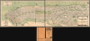
Map of New York City Published by Student Guide Publishing Co. Inc. New York, N.Y.
New York at the Start of the Great Depression
$1,200.00
Choose a Collection:
- Digital Map Information
- Suitable for large format printing
- File Size: 63.79 MB
- File Type: ZIP / TIFF
- ICC color profile embedded
- Delivered instantly via download link
This Item
Enquire
New York at the Start of the Great Depression
This is a whimsical, Art Deco-inspired 1930 large-format two-sheet map of New York City (Manhattan and the Bronx) prepared by the Student Guide Publishing Company. It captures the city at a period of transition, on the cusp of the great public works projects of the 1930s that would reshape the city, and particularly its connections to the wider metropolitan area.A Closer Look
The map is printed on two sheets, each 16 x 26.25 inches, which can be joined for a total of 16 x 52.5 inches. It depicts the city's streets, parks, and transportation network, including the subway lines of the Interborough Rapid Transit Company (IRT) and Brooklyn-Manhattan Transit Corporation (BMT), elevated lines, interurban trains using the Holland Tubes, bridges and tunnels (including the recently opened Holland Tunnel), and ferry lines. Parks, rivers, islands, and more are identified using an ornate, idiosyncratic typeface. Wind heads representing the North Wind and the East Wind appear in the upper right and lower left corners of the map, respectively.The map includes several features that might be perplexing to a modern resident or visitors to New York City. For instance, Roosevelt Island is referred to as Welfare Island, a term that was in use from 1921 to 1971, when the island was primarily occupied by hospitals. In the Bronx, across the Harlem River from Inwood, is a campus for New York University in what became known as University Heights. Designed by architect Stanford White (1853 - 1906), this campus opened in 1894 and remained part of NYU until 1973, when the university was facing financial troubles and sold the campus to the State of New York, after which it became the campus for Bronx Community College. \
One especially curious feature of this map is the retention of the 'Croton Reservoir,' also known as the Lower Receiving Reservoir, in Central Park, even though it had been drained by the time this map was published. This reservoir was completed in 1842, well before Central Park was finalized, and had already been made redundant by the turn of the 20th century. For years, the reservoir sat little used until it was finally drained in 1929, leaving a large, depressed green space for which several ideas were floated, including an airfield. Unfortunately, soon afterwards, the space became the site of a 'Hooverville' shantytown resulting from the Great Depression. In the mid-1930s, dirt excavated from the many tunnels and other large public works projects underway in the city was used to fill in the former reservoir and create the Great Lawn, which remains today.
Publication History and Census
This map was issued by the Student Guide Publishing Company in 1930. A reduced version of this map was later issued by Columbia University and sold in the Columbia University Bookstore as a guide map for students new to the city. This map is rare, with only three examples appearing in the OCLC (the University of Illinois at Urbana-Champaign, the University of Chicago, and the New York Public Library), though the catalog listing is dated 1931, and the dimensions suggest that these are the later, reduced reprint.Condition
Very good. Slight transference due to fold metric. Minor wear along original fold lines.
References
OCLC 15153187.