
This item below is out of stock, but another example (left) is available. To view the available item, click "Details."
Details
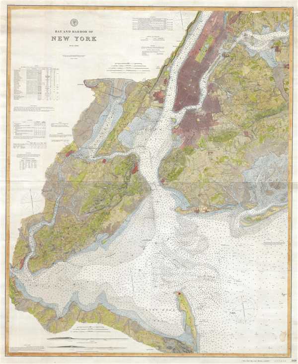
1874 U.S. Coast Survey Nautical Chart / Map of New York City Harbor
1874 (dated) $1,200.00
1889 Wall Map Sized U.S. Coast Survey Map of New York City and Harbor
NewYorkCity-uscs-1889$1,100.00

Title
Bay and Harbor of New York.
1889 (dated) 50 x 40 in (127 x 101.6 cm) 1 : 40000
1889 (dated) 50 x 40 in (127 x 101.6 cm) 1 : 40000
Description
This is a rare and dramatic 1889 wall map version of the U.S. Coast Survey nautical chart or maritime map of New York City and Harbor. Like most of its smaller predecessors, this map covers from Sandy Hook to Northern Manhattan including all of Staten Island and Brooklyn, as well as parts of Queens, the Bronx, and New Jersey. There is extraordinary detail throughout including inland to the level of individual buildings, and nautical detail in the form of countless soundings and notes. The area surrounding the map proper is tilled with a wealth of practical information for the mariner, including notes on tides, lighthouses, currents, buoys, etc.
The U. S. Coast Survey began working on its chart of New York Harbor under the its first superintendent Ferdinand Hassler. It was continued by all of his successors but most particularly A. D. Bache who oversaw the completion of that harbor's first detailed survey. Most of the work seen on this map dates to the Bache years, despite significant updates under later directors.
The present map was published in 1889, after the Coast Survey had merged with the Geodetic Survey, becoming in the process the U.S. Coast and Geodetic Survey. It was published under the tenure of T. C. Mendenhall as chart no 369. It is an independent issue on thick stock published for nautical use. At the time, it retailed of 75 cents, but prices have increased considerably since that time.
Cartographer
The Office of the Coast Survey (1807 - present) founded in 1807 by President Thomas Jefferson and Secretary of Commerce Albert Gallatin, is the oldest scientific organization in the U.S. Federal Government. Jefferson created the "Survey of the Coast," as it was then called, in response to a need for accurate navigational charts of the new nation's coasts and harbors. The spirit of the Coast Survey was defined by its first two superintendents. The first superintendent of the Coast Survey was Swiss immigrant and West Point mathematics professor Ferdinand Hassler. Under the direction of Hassler, from 1816 to 1843, the ideological and scientific foundations for the Coast Survey were established. These included using the most advanced techniques and most sophisticated equipment as well as an unstinting attention to detail. Hassler devised a labor intensive triangulation system whereby the entire coast was divided into a series of enormous triangles. These were in turn subdivided into smaller triangulation units that were then individually surveyed. Employing this exacting technique on such a massive scale had never before been attempted. Consequently, Hassler and the Coast Survey under him developed a reputation for uncompromising dedication to the principles of accuracy and excellence. Unfortunately, despite being a masterful surveyor, Hassler was abrasive and politically unpopular, twice losing congressional funding for the Coast Survey. Nonetheless, Hassler led the Coast Survey until his death in 1843, at which time Alexander Dallas Bache, a great-grandson of Benjamin Franklin, took the helm. Bache was fully dedicated to the principles established by Hassler, but proved more politically astute and successfully lobbied Congress to liberally fund the endeavor. Under the leadership of A. D. Bache, the Coast Survey completed its most important work. Moreover, during his long tenure with the Coast Survey, from 1843 to 1865, Bache was a steadfast advocate of American science and navigation and in fact founded the American Academy of Sciences. Bache was succeeded by Benjamin Pierce who ran the Survey from 1867 to 1874. Pierce was in turn succeeded by Carlile Pollock Patterson who was Superintendent from 1874 to 1881. In 1878, under Patterson's superintendence, the U.S. Coast Survey was reorganized as the U.S. Coast and Geodetic Survey (C & GS) to accommodate topographic as well as nautical surveys. Today the Coast Survey is part of the National Oceanic and Atmospheric Administration or NOAA as the National Geodetic Survey. More by this mapmaker...
Condition
Very good. Some wear to margins. Contents clean. Minor spot lower right quadrant.