
This item below is out of stock, but another example (left) is available. To view the available item, click "Details."
Details
1846 Bradford Map of New York
1846 (dated) $250.00
1839 Bradford Map of New York City
NewYorkCity2-bradford-1839$250.00

Title
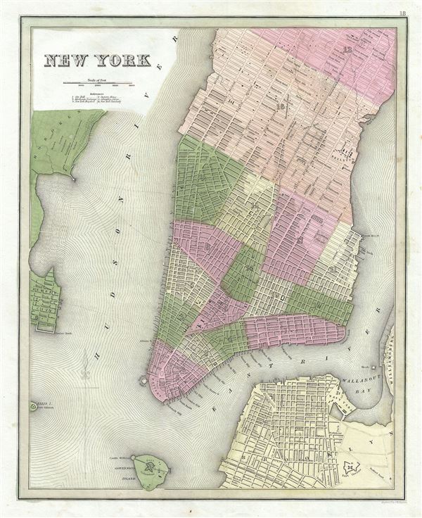
New York.
1839 (undated) 14.5 x 11.4 in (36.83 x 28.956 cm) 1 : 24000
1839 (undated) 14.5 x 11.4 in (36.83 x 28.956 cm) 1 : 24000
Description
This is Thomas Bradford's important 1839 map of New York City. Bradford's plan covers Manhattan from 53rd Street to the Battery, with parts of adjacent Brooklyn, Hoboken, and Jersey City. The whole is beautifully engraved in Boynton's delicate style, with important buildings, parks, streets, rail lines, and piers noted. Predates the landfills along the East River and on the Jersey side of the Hudson - though these are in fact ghosted in. Identifies Fort Green, the Navy yard in Brooklyn, Fort Columbus on Governor's Island, Fort Gibson on Ellis Island, City Hall, Bellevue Hospital, the Public Cemetery, the Deaf and Dumb Asylum, Tompkins Square Park, Washington Square, Castle Garden, and the Battery, among others. The Harlem Railroad appears in its original configuration extending along Fourth Avenue and then the Bowery to City Hall Park. Fine color work defines city wards of which there are but 17. This map became the prototype for a number of other important later maps of New York City by Tanner, Mitchell, and others. Engraved as plant no. 18 for the 1839 issue of Bradford's Illustrated Atlas.
CartographerS
Thomas Gamaliel Bradford (1802 - 1887) was born in Boston, Massachusetts, where he worked as an assistant editor for the Encyclopedia Americana. Bradford's first major cartographic work was his revision and subsequent republishing of an important French geography by Adrian Balbi, Abrege de Geographie published in America as Atlas Designed to Illustrate the Abridgment of Universal Geography, Modern and Ancient. Afterwards Bradford revised and expanded this work into his own important contributions to American cartography, the 1838 An Illustrated Atlas Geographical, Statistical and Historical of the United States and Adjacent Countries. Bradford's cartographic work is significant as among the first to record Texas as an independent nation. In his long career as a map publisher Bradford worked with William Davis Ticknor of Boston, Freeman Hunt of New York, Charles De Silver of Philadelphia, John Hinton, George Washington Boynton, and others. We have been able to discover little of Bradford's personal life. More by this mapmaker...
George Washington Boynton (fl. c. 1830 - 1850) was a Boston based cartographer and map engraver active in the first half of the 19th century. Boynton engraved and compiled maps for numerous publishers including Thomas Bradford, Nathaniel Dearborn, Daniel Adams, and S. G. Goodrich. His most significant work is most likely his engraving of various maps for Bradford's Illustrated Atlas, Geographical, Statistical, and Historical, of the United States and the Adjacent Countries and Universal Illustrated Atlas. He also engraved for the Boston Almanac. In 1835, Boynton is listed as an employee of the Boston Bewick Company, an engraving, stereotype, and printing concern based at no. 47 Court Street, Boston. Little else is known of his life. Learn More...
Source
Bradford, T., An Illustrated Atlas, Geographical, Statistical, And Historical, Of The United States And The Adjacent Countries, (New York) 1839.
Condition
Very good. Blank on verso. Pressmark visible.
References
Haskel, D. C., Manhattan Maps, A Co-operative List, 825. 826. 827. Rumsey 0089.001 . Phillps (atlases) 1381.