
This item below is out of stock, but another example (left) is available. To view the available item, click "Details."
Details
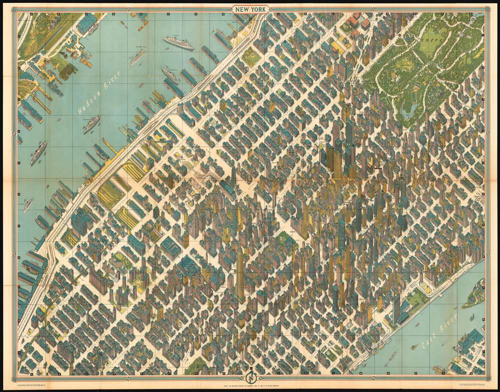
1964 Bollmann View of Midtown Manhattan/ Subway Map on Reverse
$450.00
1964 Bollmann View and Map of New York City, Midtown
NewYorkGuide-bollmann-1964$425.00

Title
New York Map-Guide
1964 (undated) 33 x 42 in (83.82 x 106.68 cm)
1964 (undated) 33 x 42 in (83.82 x 106.68 cm)
Description
The high point of 20th century urban cartographic art – the 1964 Bollmann axonometric map of midtown Manhattan – presenting the area at the stylistic peak of the skyscraper era. Bollmann created an image of great, apparent precision by employing subtle distortion and exaggeration to emphasize scale and clarity. The entire work was first drawn by hand, and its preparation boasted the use of over 67,000 photographs, 17,000 of which were aerial. Bollmann widened the streets to keep the image uncluttered; his view dispenses with perspective to maintain a uniform scale for all the buildings and allow comparison of size. The result captures the highest concentration of skyscrapers in the world of its day, presenting each with its uniquely recognizable profile: the iconic Empire State building, the graceful Art Deco curves of the Chrysler building, the sleek blade of the United Nations, and the ultra-modern helicopter pad of the Pan Am building. The verso of the map is a detailed and large-scale subway map of the five boroughs, showing the three subway lines in operation at the time: the IRT, the BMT and the IND. Another distinction between this and the earlier issues is the notation of the 1965 world's fair, and the renaming of Idlewild International Airport to JFK.
Publication History
Bollmann printed an issue of this view in Germany in 1962; there are significant typographical differences between it and the two Barnes-printed American editions of the map. Both of these New York-printed editions were brighter and livelier than the German issue. One was printed in 1963 to promote the 1964 World’s Fair; a further 1964 printing was released with the additional sponsorship of American Airlines in 1964 when the fair was extended an additional year. The American Airlines ticket offices which can be found marked throughout the view do not appear in the earlier editions. A further printing of this view, printed on one side in a smaller format and lacking a guide book , was issued in the 1980s.Cartographer
Herman Bollmann (1911 - 1971) was a German cartographer and map maker active from roughly 1940 to 1970. Before World War II, Bollmann was a well-known woodcarver and engraver based in Braunschweig, Germany. Following the war, Bollmann developed a reputation as a printer of unique three-dimensional maps. Working over a period of 25 years, Bollmann established a reputation as an artistic cartographer, producing over 39 unique projections of various cities in Europe and America. Bollmann revived the 19th-century cartographic technique known as Vogelschaukarten, a way of making three-dimensional axonometric projections. Bollmann and his team relied heavily on aerial cartography to compose distinctive cartographic masterpieces that are coveted by collectors all over the world. More by this mapmaker...
Condition
Very good condition. Comes with original gudie and pouch. Reinforced at junctures of folds.
References
cf Rumsey 3764.004. Augustyn, R. T., Cohen, P., Manhattan in Maps 1527 - 1995, 152 - 153.