This item has been sold, but you can get on the Waitlist to be notified if another example becomes available, or purchase a digital scan.
1777 Faden Map of Upper Manhattan (1860 reissue)
NewYorkNorth-valentine-1860$75.00

Title
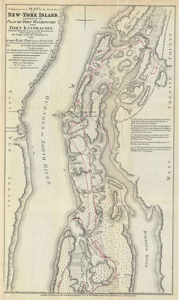
A Topographical Map of the North Part of New-York Island, exhibiting the Plan of Fort Washington, now Fort Knyphausen, With the Rebels Lines to the Southward, which were forced by the Troops under the Command of the Rt. Honble. Earl Percy on the 16th Novr. 1776, and Survey'd immediately after by order of his Lordship. By Claude Joseph Sauthier.
1859 (dated) 18 x 10.5 in (45.72 x 26.67 cm)
1859 (dated) 18 x 10.5 in (45.72 x 26.67 cm)
Description
This is an uncommon of the northern part of New York City issued 1860 for Valentine's Manual of the Corporation of New York. Originally prepared in 1777 by William Faden to illustrate the struggle for control of New York City during the American Revolutionary Wary, this map covers upper Manhattan, including the area now known as Washington Heights. Fort Washington is featured in the center along with Fort Lee or Fort Constitution across the Hudson River in New Jersey. This important revolutionary era map depicts the Battle of Fort Washington in 1776, when the British and Hessian soldiers, under the command of General Howe and Wilhelm von Knyphausen, attacked New York City which was defended by the 'rebels' under George Washington.
After capturing Long Island in 1776, the British moved northward and defeated the American Army in White Plain in October 1777. In November 1777, General Howe attacked the troops left behind at Fort Washington and forced them to surrender. Almost three thousand men were taken prisoners as a result of what is believed to be one of the biggest errors of war on the part of General Washington.
The map features a lettered key near the right margin annotating the various stages of the battle. This map, copied from a map in the State Library of Albany, identifies Claude Joseph Sauthier as the original cartographer. This map was engraved by George Hayward for the 1860 edition of D. T. Valentine's Manual.
CartographerS
William Faden (July 11, 1749 - March 21, 1836) was a Scottish cartographer and map publisher of the late 18th century. Faden was born in London. His father, William MacFaden, was a well-known London printer and publisher of The Literary Magazine. During the Jacobite Rebellion (1745 - 1746), MacFaden changed his family name to Faden, to avoid anti-Scottish sentiment. Faden apprenticed under the engraver James Wigley (1700 - 1782), attaining his freedom in 1771 - in the same year that Thomas Jefferys Sr. died. While Thomas Jefferys Sr. was an important and masterful mapmaker, he was a terrible businessman, and his son, Jefferys Jr., had little interest in building on his father's legacy. MacFaden, perhaps recognizing an opportunity, purchased his son a partnership in the Jefferys firm, which subsequently traded as 'Faden and Jefferys'. Jefferys Jr. also inherited Jefferys Sr.'s title, 'Geographer to the King and to the Prince of Wales'. With little interest in cartography or map publishing, Jefferys Jr. increasingly took a back seat to Faden, and by 1776, he had withdrawn from day-to-day management, although he retained his financial stake. The American Revolutionary War (1775 - 1783) proved to be a boom for the young 'Geographer to the King', who leveraged existing materials and unpublished manuscript maps to which he had access via his official appointment to publish a wealth of important maps, both for official use and the curious public - this period of prosperity laid the financial underpinning for Faden, who by 1783, at the end of the war, acquired full ownership of the firm and removed the Jefferys imprint. In 1801, he engraved and published the first maps for the British Ordnance Survey. By 1822, Faden published over 350 maps, atlases, and military plans. He retired in 1823, selling his plates to James Wyld Sr. Faden died in 1836. More by this mapmaker...
David T. (Thomas) Valentine (1801 - 1869) served as the Clerk of the Common Council of New York City. He edited and published a series of New York City almanacs and fact books entitled Manual of the Corporation of The City of New York. Valentine's Manual, as it came to be called, included facts about the City of New York, City Council information, city history, and reported on the progress of public works such as Central Park. The production of this annual manual was the responsibility of the Clerk of the City of New York, a position held at different times by D. Valentine and by Joseph Shannon (fl. c. 1850 - 1869), who also produced a similar manual. Valentine used his manual to reproduce some of the rarest and most important maps of New York City ever created. Learn More...
Source
Valentine's Manual of the Corporation of the City of New York, (1860 edition).
Condition
Very good. Original fold lines visible. Professionally flattened and backed with archival tissue.