This item has been sold, but you can get on the Waitlist to be notified if another example becomes available, or purchase a digital scan.
1939 Hagstrom Map of New York City w/Subway IRT and BMT lines
NewYorkSubways-hagstrom-1939$200.00

Title
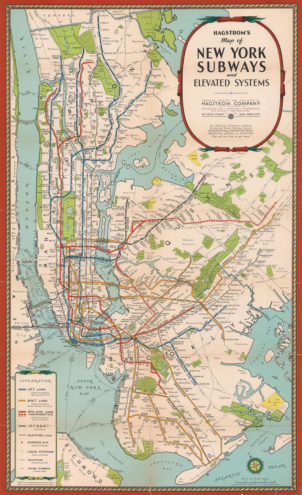
Hagstrom's Map of New York Subways and elevatd Systems.
1939 (undated) 27 x 16.5 in (68.58 x 41.91 cm)
1939 (undated) 27 x 16.5 in (68.58 x 41.91 cm)
Description
An uncommon early c. 1939 edition of Hagstrom's map of New York City showing subways and elevated trains, including the BMT and IRT lines. The map covers most of New York City with the exception of Staten Island. Parks are detailed, as are major avenues and streets, but he focus of the map is the subway and transit lines. Color coding defines the lines, the IRT (blue), BMT (yellow), 8th Avenue line (Red), Joint lines (blue and yellow). The map also attempts to show major railway lines. This map is undated but predates the 1939 merger of the December 12, 1939 merger of the IRT, BMT, IND (independent lines), the largest railroad merger in U.S. history.
Publication History and Census
This map went through many states and editions, most of which are undated. We have tentatively dated this example to 1939 based upon the design, copyright notices, and an assessment of the content.Cartographer
Andrew Gunnar Hagstrom (1890 - September 24, 1977) was a map publisher based in Maspeth, Queens. Hagstrom was a Swedish immigrant who came to new York in 1909 where took work milking cows at a farm near Coney Island, Brooklyn. He then worked in the meat packing industry while taking a degree in commercial art at the New York Mechanics Institute. Afterwords he founded a drafting business in Manhattan, creating a map to illustrate his drafting skill help customers locate his shop. His map proved popular and he expanded operations, founding the Hagstrom Map Company (1916 - 1968) and issuing additional maps of various parts of New York City and the surrounding regions. By 1949, Hagstrom had issued more than 150 maps, guides, and atlases, most of which focused on New York. Hagstrom pioneered a cartographic style that exaggerated street size to increase clarity and create additional room for large print readable labeling. Even the New York Subway system hired Hagstrom to produce its map, which was in use from the 1940s to 1958. Hagstrom died in 1977, at the age of 81. Hagstrom was knighted by the King of Sweden. His company flourished until 1968 when it was acquired by Macmillan. The brand has since passed through multiple corporate portfolios and is currently the property by Kappa Publishing Group. More by this mapmaker...
Condition
Good. Laid down on archival tissue. Wear at old fold lines and intersections.