This item has been sold, but you can get on the Waitlist to be notified if another example becomes available, or purchase a digital scan.
1850 Norie Blueblack Chart or Map of American Coast: New York to Florida
NewYorktoFlorida-norie-1850$2,500.00

Title
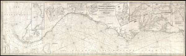
Chart of the Coast of America, from New York and Philadelphia, to the Strait or Gulf of Florida, and from thence to the Mississippi.
1850 (dated) 32.5 x 10⁷ in (82.55 x 271.78 cm) 1 : 800000
1850 (dated) 32.5 x 10⁷ in (82.55 x 271.78 cm) 1 : 800000
Description
An utterly spectacular and sprawling 1850 John Williams Norie blueback nautical chart or maritime map depicting the North American coastline from New York to the Florida Keys. The map is oriented to the west, as a navigator from Europe would approach the American coastline, and presents a detailed study of New York Harbor, the Delaware Bay, the Chesapeake Bay, the Outer Banks, and the Florida Coast including a full treatment of the Keys and parts of Cuba and the Bahamas. A series of insets expand the map's scope to the west coast of Florida including the Tampa Bay area, and the coasts of Alabama and Mississippi as far as New Orleans. A series of additional inset maps detail various rivers and harbors, including: St. Augustine, the Nassau River, the St. Mary's River, the entrance to the Savannah River, Port Royal, Charleston, Beaufort, the Delaware Bay, the Patuxent River, and New York Harbor. Although there is little inland data, there are comprehensive treatments of the Delaware and Chesapeake Bays. The seas are full of depth soundings, shading, and nautical calculations, while the landside portions of the chart include annotations, sailing directions, and information on lighthouses.
The Illicit Sources Behind the Chart
Cartographically, Norie based this chart on an earlier map covering the same region first issued by Robert Laurie and James Whittle in 1808. That map itself was based upon late 18th century regional maps also by Laurie and Whittle. It is not clear if this is a piracy of the Laurie and Whittle chart or if they sold the plates to Norie, as Laurie and Whittle remained active until 1858. Laurie and Whittle attribute this map to the marine surveys of Captain N. Holland (Samuel Holland). The name 'N. Holland' appears on several nautical charts issued by Laurie and Whittle in the late 18th and early 19th century. 'N. Holland' never existed as such, the name was a pseudonym for the important British nautical surveyor Samuel Holland. Holland, along with Gerard William DeBrahm, was the primary colonial maritime surveyor for Britain's North American colonies up to and during the American Revolutionary War. To offset their poor colonial salaries, early naval surveyors would often sell the results of their official survey work to private publishers. By only slightly altering Holland's name, the well-deserved respect accorded to his work would lend prestige to the privately published chart, while at the same time preventing a backlash from Holland's government employers. In this case, since we know that most of Holland's survey work was focused on the northern North American colonies (Canada), the present map is more than likely derived from the work Holland's colleague, DeBrahm. Whether or not DeBraham received compensation for his work through Holland is unclear.
The present example bears in imprint of John Williams Norie, one of the largest and most active nautical chart publishers in London. The first Norie edition of this map appeared in 1837. Revised Norie editions were issued in 1850 and 1856. This is the only known example of the 1850 edition.
CartographerS
John William Norie (June 3, 1772 - December 24, 1843) was a British teacher of navigation, hydrographer, chart maker, and publisher of maritime manuals active in London, England in the late 18th and early 19th centuries. Norie was born in Wapping, London, an area long associated with the maritime sciences. Norie's career as a chart maker commenced under the tutelage of William Heather, a prominent purveyor and publisher of nautical charts, pilot books, and navigational tools who took over the firm of Mount and Page in 1765. Heather and Norie were likely acquainted through John Hamilton Moore, another important chart maker with whom both seem to have been associated early in their careers. Heather hired Norie to teach basic navigation at his shop at 157 Leadenhall Street. Under Heather Norie also distinguished himself as a draftsman, completing many of the early charts associated with the Heather firm. When Heather died in 1812 John Norie partnered with George Wilson, a moneyed 'man about town' with little experience in the maritime trades, to acquire the map and chart business at 9500 British Pounds. It proved a good deal for Norie, who retained all copyright privileges and drew 1/4 quarter share of business profits, as well an impressive quarterly salary and, for doing all of the work, 1/3rd of Wilson's share. The firm, referred to as the 'Naval Warehouse' quickly acquired a reputation for quality navigational materials and became a favorite of merchant seamen. It was even referenced in Charles Dickens' classic novel Dombey and Son. In 1819, Norie and Wilson acquired the failing chart business of David Steel, which significantly increased the size, though not quality, of their chart catalogue. With the rise of the British Admiralty and its own maritime chart productions, the business of "Chart Purveyor" in London dramatically changed. Admiralty charts and pilot books, designed for military use, were offered through established intermediaries, like Norie, at bargain prices. Most chart makers of the period found it profitable to use the highly technical Admiralty charts to update their own more decorative vernacular charts. For a brief time this practice proved exceptionally profitable but eventually began to draw criticism. Nonetheless, Norie retired to Edinburgh in 1840 and died a wealthy man in 1843. In 1840 the business passed to a nephew of George Wilson, Charles Wilson, who renamed the firm "Norie & Wilson". William Heather Norie, J. W. Norie's own son, produced few charts, instead pursuing a career in the legal field. Norie & Wilson merged with James Imray's prosperous chart business in 1899, becoming Imray, Laurie, Norie & Wilson, a profitable concern that remains active in the maritime charting industry. More by this mapmaker...
Laurie and Whittle (fl. 1794 - 1858) were London, England, based map and atlas publishers active in the late 18th and early 19th century. Generally considered to be the successors to the Robert Sayer firm, Laurie and Whittle was founded by Robert Laurie (c. 1755 - 1836) and James Whittle (1757-1818). Robert Laurie was a skilled mezzotint engraver and is known to have worked with Robert Sayer on numerous projects. James Whittle was a well-known London socialite and print seller whose Fleet Street shop was a popular haunt for intellectual luminaries. The partnership began taking over the general management of Sayer's firm around 1787; however, they did not alter the Sayer imprint until after Sayer's death in 1794. Apparently Laurie did most of the work in managing the firm and hence his name appeared first in the "Laurie and Whittle" imprint. Together Laurie and Whittle published numerous maps and atlases, often bringing in other important cartographers of the day, including Kitchin, Faden, Jefferys and others to update and modify their existing Sayer plates. Robert Laurie retired in 1812, leaving the day to day management of the firm to his son, Richard Holmes Laurie (1777 - 1858). Under R. H. Laurie and James Whittle, the firm renamed itself "Whittle and Laurie". Whittle himself died six years later in 1818, and thereafter the firm continued under the imprint of "R. H. Laurie". After R. H. Laurie's death the publishing house and its printing stock came under control of Alexander George Findlay, who had long been associated with Laurie and Whittle. Since, Laurie and Whittle has passed through numerous permeations, with part of the firm still extant as an English publisher of maritime or nautical charts, 'Imray, Laurie, Norie and Wilson Ltd.' The firm remains the oldest surviving chart publisher in Europe. Learn More...
Samuel Holland (1728 - December 28, 1801) was a surveyor and cartographer of extraordinary skill and dedication. Holland was born in the Netherlands in 1728 and, at 17, joined the Dutch Army where he attained the rank of Lieutenant. Around 1754 Holland emigrated to England where he joined the newly forming Royal American Regiment. His skills as a cartographer and surveyor brought him to the attention of his superiors who offered him steady promotions. In 1760 he prepared an important survey of the St. Lawrence River system. It was during this survey that Holland met a young James Cook, who he mentored in the art of surveying. Cook, best known for his exploration of the Pacific, developed many of his own revolutionary nautical surveying techniques based the systems he learnt from Holland. In 1762 Holland caught the attention of the Commission of Trade and Plantations, who governed the British Crown Colonies in America. Under the umbrella of the Trade Commission Holland prepared surveys of the Hudson River Valley and other New York properties. In 1764 he was named Surveyor General for the Northern District, the position in which he did much of his most important work. Holland is also known for surveying done in an attempt to sort out the New York - New Jersey border conflict. Following his work in New York Holland relocated to Canada where, with his new wife of just 21 years, he sired seven children. Like many early surveyors working for colonial governments, Holland was poorly compensated and is known to have supplemented his income by selling the results of his surveys, and those of other surveyors to which he had privileged access, to private publishers, among them the London firm of Laurie and Whittle, who published his work under the pseudonym of 'Captain N. Holland.' Samuel Holland died in Quebec in 1801. Learn More...
Condition
Very good. Backed on blue paper. Silk edging.
References
OCLC 71416402. Library of Congress, G3702.C6P5 1837 .N6. New York Public Library, Map Division, Map Div. 97-6023 [LHS 254, rolled].