This item has been sold, but you can get on the Waitlist to be notified if another example becomes available, or purchase a digital scan.
1774 Cook Map of New Zealand
NewZealand-cook-1774$925.00

Title
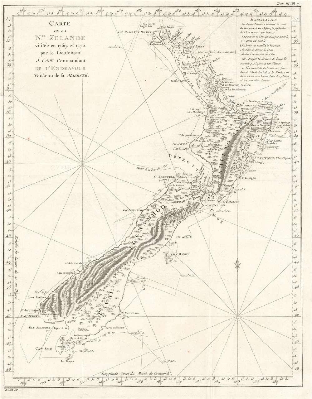
Carte de la Nle. Zelande visitée en 1769 et 1770 par le Lieutenant J. Cook Commandant de l'Endeavour vasseau de sa Majesté.
1774 (undated) 15.25 x 20 in (38.735 x 50.8 cm) 1 : 3800000
1774 (undated) 15.25 x 20 in (38.735 x 50.8 cm) 1 : 3800000
Description
Recognized as the most important map in the history of New Zealand, this is the first French edition of Captain James Cook's landmark map of New Zealand. The first map to prove that New Zealand is composed of two islands, Cook's course through what is still known as Cook's Strait separating the two islands, is depicted as well.
Cook's Exploration of New Zealand
Cook undertook the surveys used to create this work during his first voyage in 1769 and 1770, making him and his crew the first Europeans to visit the islands since they were discovered by Dutch explorer Abel Tasman in the early 1640s. Cook's map is also the first to detail the coastline of both islands and labels their points, bays, and capes. The mountainous interior topography as it was perceived from Cook's ship and the shore is also illustrated. The course of Cook's ship, the HMS Endeavor, is traced as well, with dates, depth soundings, and compass headings noted. Many of the place names Cook bestowed upon the islands remain to this day, including Mount Egmont, the Bay of Plenty, Hawke's Bay, the Bay of Islands, and the Bay of Kidnappers.The Chart in Cook's Words
Of the chart itself, Cook wrote in his journals:The Chart which I have drawn will best point out the figure and extent of these Islands…beginning at Cape Palliser and proceed round Aehei no mouwe (North Island) by the East Cape etc. The coast between these two capes I believe to be laid down pretty accurate both in its figure and the course and distance from point to point. The opportunities I had and the methods I made use on to obtain these requesit4es were such as could hardly admit of an error…some few places however must be excepted and these are very doubtful…Cook's achievement in mapping New Zealand established the value of the islands as potential colony and point of greater interest for the British.
Publication History and Census
After Cook returned to England from this voyage, he brought with him over 300 manuscript maps and charts. Isaac Smith (1752 - 1831), a draftsman who worked with Cook and was a member of the Endeavor's crew, had a hand in drawing this map. It was first printed in John Hawkesworth's An Account of the Voyages undertaken by the order of His Present Majesty for making Discoveries in the Southern Hemisphere…, which was the first official account of Cook's first voyage and was supported by the British Admiralty. This work not only recounted Cook's explorations, but also those of Wallis, Carteret, and Byron, who also explored the Pacific in the 1760s. The present example was engraved by Robert Bénard (1734 - 1785) and published in the French version of Hawkesworth's book, entitled Relation des voyages entrepris par order de sa Majestie Britannique… published by Saillant and Nyon and Panckoucke in 1774. Impressively, the British Hydrographic Office began reprinting this chart for their vessels beginning in 1816 and it was consulted by mariners well into the twentieth century, lending it incredible longevity. Because of its accuracy and the complexity of the task, it is considered to be one of Cook's best maps. The OCLC records examples as being part of the collections at Princeton, the University of Auckland, the National Library of New Zealand, the Museum of New Zealand, and the National Library of Australia.CartographerS
Captain James Cook (7 November 1728 - 14 February 1779) is a seminal figure in the history of cartography for which we can offer only a cursory treatment here. Cook began sailing as a teenager in the British Merchant Navy before joining the Royal Navy in 1755. He was posted in America for a time where he worked Samuel Holland, William Bligh, and others in the mapping of the St. Lawrence River and Newfoundland. In 1766 Cook was commissioned to explore the Pacific and given a Captaincy with command of the Endeavour. What followed were three historic voyages of discovery, the highlights of which include the first European contact with eastern Australia, the discovery of the Hawaiian Islands (among many other Polynesian groups), the first circumnavigation of New Zealand, some of the first sightings of Antarctica, the first accurate mapping of the Pacific Northwest, and ultimately his own untimely death at the hands of angry Hawaiians in 1779. The influence of Cook work on the mapping and exploration of the Pacific cannot be understated. More by this mapmaker...
Robert Bénard (1734 - c. 1785) was a French engraver. Born in Paris, Bénard is best known for supplying a significant number of plates (at least 1,800) for the Encyclopédie published by Diderot and Alembert. He also is remembered for his work with the Académie des Sciences, most notably the Descriptions des Arts et Métiers Learn More...
Condition
Very good. Light wear along original fold lines. Light foxing. Verso repair to minor fold separation. Minor closed margin tear professionally repaired on verso. Blank on verso.
References
OCLC 221146798.