This item has been sold, but you can get on the Waitlist to be notified if another example becomes available, or purchase a digital scan.
1773 Hawkesworth / Cook Map, Bays of Northern New Zealand
NewZealand-hawkesworth-1773$200.00

Title
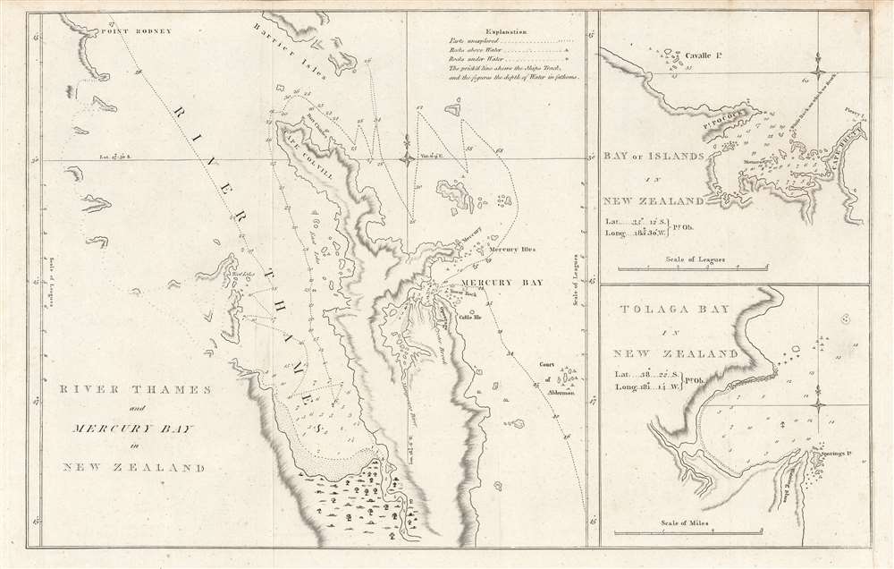
River Thames and Mercury Bay..., Bay of Islands..., Tolaga Bay...
1773 (undated) 10.75 x 17 in (27.305 x 43.18 cm) 1 : 54000
1773 (undated) 10.75 x 17 in (27.305 x 43.18 cm) 1 : 54000
Description
This is an important map of the bays of northern New Zealand (Mercury, Tolaga, Bay of Islands, and the Firth of Thames) published by John Hawkesworth in his An account of the voyages undertaken, a 1773 book recounting recent British voyages to the Pacific, including the first voyage of Captain James Cook. The map is based on Cook's papers and sketches and constitutes the first detailed map of these bays.
Mercury Bay was so named because Cook stopped there to observe the transit of Mercury, which allowed him to accurately determine his geographic coordinates, noted here. Cook and his crew, including several scientists, also went ashore, collected flora, and interacted with local Māori, before heading out to circumnavigate New Zealand, resulting in the first map to correctly illustrate New Zealand as two islands.
A Closer Look
The course of Cook's ship, the HMS Endeavor, including where it anchored, is traced on the main map, with depth soundings noted throughout. Cook's mapping of these bays was critical to later voyagers, especially as these waters can be difficult to navigate with so many rocks (both above and below water) and shallows. Cook notes that his ship struck a rock, dubbed 'Whale Rock,' near the mouth of the Bay of Islands.Mercury Bay was so named because Cook stopped there to observe the transit of Mercury, which allowed him to accurately determine his geographic coordinates, noted here. Cook and his crew, including several scientists, also went ashore, collected flora, and interacted with local Māori, before heading out to circumnavigate New Zealand, resulting in the first map to correctly illustrate New Zealand as two islands.
Cook's Exploration of New Zealand
Cook undertook the surveys used to create this work during his first voyage in 1769 and 1770, making him and his crew the first Europeans to visit the islands since their 1640s discovery by Dutch explorer Abel Tasman. Many of the place names Cook bestowed upon the islands and waters remain to this day, including Mercury Bay, Tolaga Bay (the name is apparently derived from Cook's butchering of an unknown Māori word), and the Firth of Thames (the river has been restored to its indigenous Māori name, Waihou). Mercury Bay (Te-Whanganui-a-Hei) also plays an important role in the mythology and oral history of the Māori, particularly regarding the semi-mythological explorer Kupe, who is said to have discovered the bay centuries before.Publication History and Census
This map was published in 1773 by John Hawkesworth, using Cook's papers, in his An account of the voyages undertaken by the order of His present Majesty…, which recounted Cook's first voyage and other recent explorations of the Pacific. Hawkesworth's work was commissioned by the Admiralty and published by the London publishers Strahan and Cadell, becoming an instant sensation given the excitement around Cook's discoveries. The present edition of the map is held by the National Library of Australia, the University of Otago, and the National Library of New Zealand, and is scarce to the market.CartographerS
John Hawkesworth (c. 1715 - November 16, 1773) was an English born writer and editor born London. Hawkesworth, who is said to have been self educated, succeeded Samuel Johnson as the parliamentary debate compiler for "Gentleman's Magazine". He was a deeply religious and moral map who brilliant defense of morality earned him an LL. D degree from the Archbishop of Canterbury. Hawkesworth went on to publish a series of scholarly books and essays including a 12 volume edition of Jonathan Swift's work. In 1772 Hawkesworth was commissioned by the Admiralty to compile and edit James Cook's journals. The resultant work An Account of the Voyages undertaken ... for making discoveries in the Southern Hemisphere was one of the first ethnographic account of the South Seas and was widely published in England and abroad. Though highly influential, Hawkesworth's work received heavy criticism from scholars who claim that he liberally altered much of the text in the name of morality. More by this mapmaker...
Captain James Cook (7 November 1728 - 14 February 1779) is a seminal figure in the history of cartography for which we can offer only a cursory treatment here. Cook began sailing as a teenager in the British Merchant Navy before joining the Royal Navy in 1755. He was posted in America for a time where he worked Samuel Holland, William Bligh, and others in the mapping of the St. Lawrence River and Newfoundland. In 1766 Cook was commissioned to explore the Pacific and given a Captaincy with command of the Endeavour. What followed were three historic voyages of discovery, the highlights of which include the first European contact with eastern Australia, the discovery of the Hawaiian Islands (among many other Polynesian groups), the first circumnavigation of New Zealand, some of the first sightings of Antarctica, the first accurate mapping of the Pacific Northwest, and ultimately his own untimely death at the hands of angry Hawaiians in 1779. The influence of Cook work on the mapping and exploration of the Pacific cannot be understated. Learn More...
Thomas Cadell the elder (November 12, 1742 - December 27, 1802) was an English publisher and bookseller. Born in Bristol, Cadell was apprenticed to a London bookseller named Andrew Millar in March 1758, and became Millar's partner in April 1765 after finishing his seven-year apprenticeship. He took over the business with the help of Millar's assistant following Millar's death in 1768. Not only was Cadell a successful bookseller, but he also found success in publishing, publishing poetry by Robert Burns, and works by jurist William Blackstone, economist Adam Smith, and Edward Gibbon's Decline and Fall of the Roman Empire. Cadell married the daughter of Reverend Thomas Jones on April 1, 1769, with whom he had two children, a son and a daughter. Cadell retired in 1793 and his son, Thomas Cadell the younger (1773 - 1836), took over the business. Cadell died at home of an asthma attack on December 27, 1802. Learn More...
Condition
Very good. Fold line visible towards left-center.
References
Rumsey 3403.039. OCLC 949713970.