This item has been sold, but you can get on the Waitlist to be notified if another example becomes available, or purchase a digital scan.
1888 Philip Map of New Zealand and Polynesia
NewZealandPolynesia-philip-1888$125.00

Title
Philips Authentic Map of New Zealand Mounted on Cloth.
1888 (undated) 21.5 x 25.5 in (54.61 x 64.77 cm)
1888 (undated) 21.5 x 25.5 in (54.61 x 64.77 cm)
Description
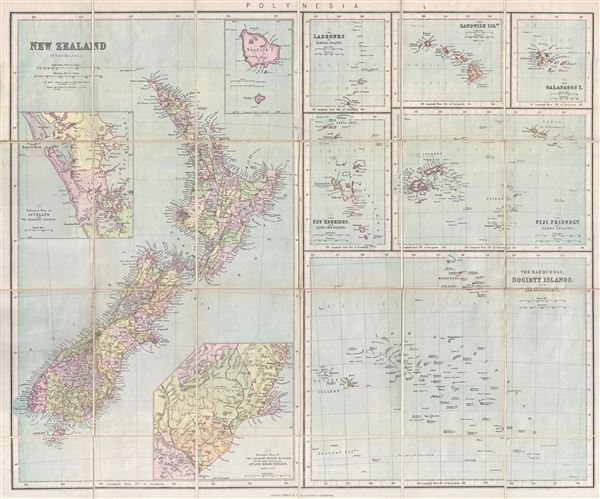
This is a beautiful example of George Philip's 1888 pocket map of New Zealand and the islands of Polynesia. This is essentially seven maps compiled onto a single sheet. The left map, covering half of the sheet, focuses on New Zealand with three inset maps of Auckland and the adjacent country, the country around Dunedin and the eastern portion of the Otago Gold-Fields, and Norfolk and Philip Islands. The lower right section features a quarter-sheet map detailing the Marquesas (of Typee fame), Society Islands, and the Low Archipelago. Other maps in the upper right quadrant detail Fiji, the Friendly Island (Tonga) and Samoa, the New Hebrides and Santa Cruz Islands, the Ladrones or Mariana Islands, the Hawaii, and the Galapagos Islands (made famous by Darwin's discoveries). Throughout Philip identifies various cities, towns, rivers, mountains, and an assortment of additional topographical details with relief shown by hachures. Prepared by William Hughes F. R. G. S. and first published by George Philip & Sons. There is no date on this map, but Philip began advertising it in 1888, which corresponds to the style and printing techniques used.
Cartographer
George Philip (1800 - 1882) was a map publisher and cartographer active in the mid to late-19th century. Philip was born into a Calvinst family in Huntly, Aberdeenshire, Scotland. Around 1819 he apprenticed himself to William Grapel, a Liverpool printer and bookseller. Fifteen years later, in 1834, Philip founded his own Liverpool book and map firm. Philip's earliest cartographic ventures were mostly educational material issued in tandem with John Bartholomew Sr., August Petermann, and William Hughes. In 1848, Philip admitted his son, George Philip Jr. (1823 - 1902) into the firm, renaming it George Philip and Son Ltd. George Philip Jr. ran the firm until his death in 1902, by which time it had developed into a major publishing concern. His successors established the London Geographical Institute, a factory where they embraced modern printing techniques to produce thousands of economical and high quality maps. In April 1988, George Philip & Son was acquired by Octopus Publishing, a branch of Reed International. Nonetheless, today the firm trades and publishes to this day as George Philip and Son. More by this mapmaker...
Condition
Very good. Dissected and mounted on linen. Original linen in good condition. Folds into linen binder.