This item has been sold, but you can get on the Waitlist to be notified if another example becomes available, or purchase a digital scan.
1772 Vaugondy / Diderot Map of North America & the Northwest Passage
NordetOuestAmerique-vaugondy-1772$325.00

Title
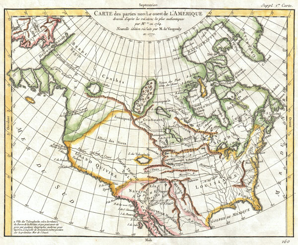
Carte des Parties Nord et Ouest de l'Amerique Dressee d'apres les Relations les Plus Authentiques par M *** en 1764.
1772 (dated) 11.5 x 14.5 in (29.21 x 36.83 cm)
1772 (dated) 11.5 x 14.5 in (29.21 x 36.83 cm)
Description
A truly remarkable 1772 map of North America by Robert de Vaugondy. Based upon an earlier map of the region by Thomas Engel, this is a fascinating examination of the general layout and waterways of North America – especially in the west. Curiously does not specifically show a Northwest Passage, but leaves clear the possibility that one such passage may indeed exist. Rivers and lakes extending from the eastern part of the continent almost, but never quite meet their counterparts from the west. While the east is displayed with reasonable accuracy, the cartography of the western part of North America is almost entirely conjectural and based upon early reports from Jesuit missionaries. Six largely mythical river systems extend inland from the Pacific or, as it appears on this map, 'Mer du Sud.' Several meet with enormous and interesting mythical lakes. The northern most of these is Lake Conibas, the center of a supposed lake region that first appeared in Mercator's 1569 map of America. Mercator's version of Conibas been loosely interpreted, depending upon the source, as the Northwest Passage, the Hudson Bay, or the first map of the Great Lakes. Vaugondy situates this region is further west, making it the source of several river systems and a potential station in a 'northwest passage.' Another lake, further south is labeled the 'L. des Tahuglauks.' This lake, which is shown as the source of the mythical 'River of the West,' was first reported by the French traveler Baron de Lahonton, who claimed to have traveled in this area in 1702. After traveling westward along what he called the 'R. Longue,' which is shown, he claims to have arrived at the city of Moseemlek. There the local tribal peoples reported the existence of a large salt water lake to the west, possibly an early report of Great Salt Lake. Back in France, De L'Isle added the lake to his map of North America and, later, Vaugondy included it on this map. There are also a number of interesting political features. The region that roughly corresponds to modern Alaska is labeled Anian Regnum. Here is a real cartographic curiosity, where myth become fact, which again becomes myth. Anian is a term derived from the journals of Marco Polo and its first cartographic appearance is in a 1561 map by the Venetian cartographer Bolognini Zaltieri. Later it was popularized in a John Donne poem, 'Anyan if I go west by the North-West passage.' However, it was interpreted as the Bering Strait by cartographers, successfully transitioning it from the realms of poetry into cartography. Anian presupposed the existence of a Northwest Passage and, as such, was entirely mythical, though the lands that are now Alaska long bore that name. Further south we find 'Grand Quivira' referencing one of the many mythical Kingdoms of Gold. Much of the west is labeled 'Allies des Sioux,' an idea mostly probably derived from Jesuit missionary reports. Greenland is shown attached to the mainland. All in all, an extremely attractive and important late 18th century mapping of North America.
This map is part of the 10 map series prepared by Vaugondy for the Supplement to Diderot's Encyclopédie, of which this is plate 1. This seminal map series, exploring the mapping of North American and specifically the Northwest Passage was one of the first studies in comparative cartography.
This map is part of the 10 map series prepared by Vaugondy for the Supplement to Diderot's Encyclopédie, of which this is plate 1. This seminal map series, exploring the mapping of North American and specifically the Northwest Passage was one of the first studies in comparative cartography.
CartographerS
Robert de Vaugondy (fl. c. 1716 - 1786) was French may publishing from run by brothers Gilles (1688 - 1766) and Didier (c. 1723 - 1786) Robert de Vaugondy. They were map publishers, engravers, and cartographers active in Paris during the mid-18th century. The father and son team were the inheritors to the important Nicolas Sanson (1600 - 1667) cartographic firm whose stock supplied much of their initial material. Graduating from Sanson's maps, Gilles, and more particularly Didier, began to produce their own substantial corpus. The Vaugondys were well-respected for the detail and accuracy of their maps, for which they capitalized on the resources of 18th-century Paris to compile the most accurate and fantasy-free maps possible. The Vaugondys compiled each map based on their own geographic knowledge, scholarly research, journals of contemporary explorers and missionaries, and direct astronomical observation. Moreover, unlike many cartographers of this period, they took pains to reference their sources. Nevertheless, even in 18th-century Paris, geographical knowledge was limited - especially regarding those unexplored portions of the world, including the poles, the Pacific Northwest of America, and the interiors of Africa, Australia, and South America. In these areas, the Vaugondys, like their rivals De L'Isle and Buache, must be considered speculative or positivist geographers. Speculative geography was a genre of mapmaking that evolved in Europe, particularly Paris, in the middle to late 18th century. Cartographers in this genre would fill in unknown lands with theories based on their knowledge of cartography, personal geographical theories, and often dubious primary source material gathered by explorers. This approach, which attempted to use the known to validate the unknown, naturally engendered rivalries. Vaugondy's feuds with other cartographers, most specifically Phillipe Buache, resulted in numerous conflicting papers presented before the Academie des Sciences, of which both were members. The era of speculative cartography effectively ended with the late 18th-century explorations of Captain Cook, Jean Francois de Galaup de La Perouse, and George Vancouver. After Didier died, his maps were acquired by Jean-Baptiste Fortin, who in 1787 sold them to Charles-François Delamarche (1740 - 1817). While Delamarche prospered from the Vaugondy maps, he defrauded Vaugondy's window Marie Louise Rosalie Dangy of her rightful inheritance and may even have killed her. More by this mapmaker...
Denis Diderot (October 5, 1713 - July 31, 1784) was a French Enlightenment era philosopher, publisher and writer. Diderot was born in the city of Langres, France and educated at the Lycée Louis le Grand where, in 1732, he earned a master of arts degree in philosophy. Diderot briefly considered careers in the clergy and in law, but in the end chose the more fiscally challenge course of a writer. Though well respected in philosophical circles Diderot was unable to obtain any of the government commissions that commonly supported his set and consequently spent much of his life in deep poverty. He is best known for his role in editing and producing the Encyclopédie . The Encyclopédie was one of the most revolutionary and impressive works of its time. Initially commissioned as a translation of Ephraim Chambers' Cyclopaedia, or Universal Dictionary of Arts and Sciences, Diderot instead turned into a much larger and entirely new work of monumental depth and scope. Diderot's Encyclopédie was intended to lay bare before the common man the intellectual mysteries of science, art and philosophy. This revolutionary mission was strongly opposed by the powers of the time who considered a learned middle class it a threat to their authority. In the course of the Encyclopédie production Diderot was imprisoned twice and the work itself was officially banned. Nonetheless, publication continued in response to a demand exceeding 4000 subscribers. The Encyclopédie was finally published in 1772 in 27 volumes. Following the publication of the Encyclopédie Diderot grew in fame but not in wealth. When the time came to dower his only surviving daughter, Angelique, Diderot could find no recourse save to sell his treasured library. In a move of largess, Catherine the II Russia sent an emissary to purchased the entire library on the condition that Diderot retain it in his possession and act as her "librarian" until she required it. When Diderot died of gastro-intestinal problems 1784, his heirs promptly sent his vast library to Catherine II who had it deposited at the Russian National Library, where it resides to this day. Learn More...
Source
Supplement to Diderot, D., Encyclopédie, ou dictionnaire raisonné des sciences, des arts et des métiers; or Robert de Vaugondy, G., Recueil de 10 Cartes Traitant Particulierement de L'Amerique du Nord, (Paris) 1779.
Condition
Very good condition. Wide clean margins. Original centerfold as issued. Original platemark. Blank on verso.
References
Pedley, Mary Sponberg. Bel et Utile: The Work of the Robert de Vaugondy Family of Mapmakers. 453. Portinary, Pierluigi and Knirsch, Franco, The Cartography of North America 1500-1800, #155. Wheat, C., The Mapping of the Transmississippi West, 1540-1861, 158. Kershaw, Kenneth A., Early Printed Maps of Canada, 1133. Phillips (Atlases) 1195-1.