This item has been sold, but you can get on the Waitlist to be notified if another example becomes available, or purchase a digital scan.
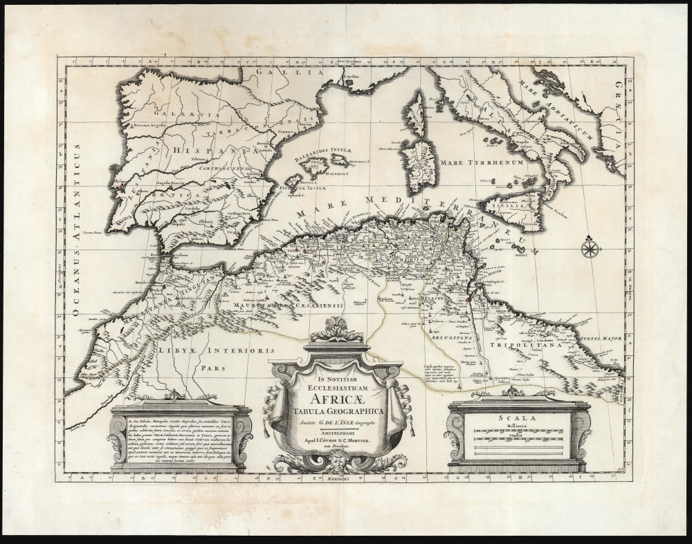
1700 / 1742 De l'Isle Map of North Africa at the time of the Council of Nicaea
NorthAfrica-delisle-1742$150.00

Title
In Notitiam Ecclesiasticam Africae Tabula Geographica Auctore G. De L'Isle Geographo Amstelodami Apud I. Covens et C. Mortier cum Privilegio.
1742 (undated) 15 x 20.75 in (38.1 x 52.705 cm) 1 : 5700000
1742 (undated) 15 x 20.75 in (38.1 x 52.705 cm) 1 : 5700000
Description
This is a 1742 Covens and Mortier edition of Guillaume de l'Isle's map of western North Africa at the time of the 325 CE First Council of Nicaea - the historic first ecumenical council of the Christian Church.
While the map's detail is focused on coastal Africa, the map also includes the Iberian Peninsula, Italy, and the European Mediterranean islands: the Balearic islands, Sardinia and Corsica, and Sicily. This latter sports a vigorously erupting Mount Etna.
A Closer Look
The map is divided by its provinces as they stood at the time of the First Council of Nicaea, 325 CE. It illustrates the towns and cities represented by attendees at this foundational meeting of church fathers. De l'Isle also marks the major cities, and the known trade routes as reported by ancient historians. De l'Isle, with his usual attention to detail, distinguished between those locations for which he had accurate reports, and those whose location he infers based on likely positions along the coast and rivers.While the map's detail is focused on coastal Africa, the map also includes the Iberian Peninsula, Italy, and the European Mediterranean islands: the Balearic islands, Sardinia and Corsica, and Sicily. This latter sports a vigorously erupting Mount Etna.
First Council of Nicaea
The First Council of Nicaea, convened in CE325 CE by Emperor Constantine, was the first ecumenical council of the Christian Church. It aimed to achieve consensus in the Church through an assembly representing all Christendom. A significant outcome of this council was the establishment of the Nicene Creed, which addressed the Arian controversy by asserting the divinity of Jesus Christ. The council also established uniform observances for the date of Easter and issued several canonical decrees. This council played a pivotal role in defining early Christian doctrine and church organization.Publication History and Census
De l'Isle produced this map for inclusion in Andreas Pralard's 1700 history of the Donatist schism, Sancti Optati Afri Milevitani episcopi De schismate donatistarum the present example was re-engraved in Amsterdam for publication by Covens and Mortier, who included the work in their Atlas Nouveau. The map is well represented in institutional collections.CartographerS
The De L'Isle family (fl. c. 1700 - c. 1760) (also written Delisle) were, in composite, a mapmaking tour de force who redefined early 18th century European cartography. Claude De L'Isle (1644 -1720), the family patriarch, was Paris based a historian and geographer under Nicholas Sanson. De L'Isle and his sons were proponents of the school of "positive geography" and were definitive figures, defining the heights of the Golden Age of French Cartography. Of his twelve sons, four, Guillaume (1675 - 1726), Simon Claude (1675 - 1726), Joseph Nicholas (1688 - 1768) and Louis (1720 - 1745), made a significant contributions to cartography. Without a doubt Guillaume was the most remarkable member of the family. It is said that Guillaume's skill as a cartographer was so prodigious that he drew his first map at just nine years of age. He was tutored by J. D. Cassini in astronomy, science, mathematics and cartography. By applying these diverse disciplines to the vast stores of information provided by 18th century navigators, Guillaume created the technique that came to be known as "scientific cartography", essentially an extension of Sanson's "positive geography". This revolutionary approach transformed the field of cartography and created a more accurate picture of the world. Among Guillaume's many firsts are the first naming of Texas, the first correct map of the Mississippi, the final rejection of the insular California fallacy, and the first identification of the correct longitudes of America. Stylistically De L'Isle also initiated important changes to the medium, eschewing the flamboyant Dutch style of the previous century in favor of a highly detailed yet still decorative approach that yielded map both beautiful and informative. Guillaume was elected to the French Academie Royale des Sciences at 27. Later, in 1718, he was also appointed "Premier Geographe du Roi", an office created especially for him. De L'Isle personally financed the publication of most of his maps, hoping to make heavy royalties on their sales. Unfortunately he met an untimely death in 1728, leaving considerable debt and an impoverished child and widow. De L'Isle's publishing firm was taken over by his assistant, Phillipe Buache who became, posthumously, his son in law. The other De L'Isle brothers, Joseph Nicholas and Louis De L'Isle, were employed in the Service of Peter the Great of Russia as astronomers and surveyors. They are responsible for cataloguing and compiling the data obtained from Russian expeditions in the Pacific and along the northwest coast of America, including the seminal explorations of Vitus Bering and Aleksei Chirikov. The De L'Isles, like their rivals the Vaugondys , must be considered speculative geographers. Speculative geography was a genre of mapmaking that evolved in Europe, particularly Paris, in the middle to late 18th century. Cartographers in this genre would fill in unknown areas on their maps with speculations based upon their vast knowledge of cartography, personal geographical theories, and often dubious primary source material gathered by explorers and navigators. This approach, which attempted to use the known to validate the unknown, naturally engendered many rivalries. The era of speculatively cartography effectively ended with the late 18th century explorations of Captain Cook, Jean Francois de Galaup de La Perouse, and George Vancouver. More by this mapmaker...
Covens and Mortier (1721 - c. 1862) was an Amsterdam publishing firm, the successor to the extensive publishing empire built by Pierre Mortier (1661 - 1711). Covens and Mortier maps are often criticized as derivative - but this is not fully the case. Pierre Mortier lived in Paris from 1681 to 1685. There he established close relationships the the greatest French cartographers of the era, including De L'Isle and D'Anville. His business model was based upon leveraging Dutch printing technology and sophistication to co-publish state of the art French cartography. Upon Mortier's death in 1711 his firm was taken over by his son, Cornelius Mortier (1699 - 1783). Cornelius married the sister of Johannes Covens (1697 - 1774) in 1721 and, partnering with his brother in law, established the Covens and Mortier firm. Under the Covens and Mortier imprint, Cornelius and Johannes continued in Pierre's model of publishing the most up-to-date French works with permission. They quickly became one of the largest and most prolific Dutch publishing concerns of the 18th century. The firm and its successors published thousands of maps over a 120 year period from 1721 to the mid-1800s. During their long lifespan the Covens and Mortier firm published as Covens and Mortier (1721 - 1778), J. Covens and Son (1778 - 94) and Mortier, Covens and Son (1794 - c. 1862). Learn More...
Source
Covens, I., and C. Mortier, Atlas Nouveau, (Amsterdam) 1742.
Condition
Very good. Some marginal mends, else excellent.
References
OCLC 316609838. Rumsey 4638.114.