This item has been sold, but you can get on the Waitlist to be notified if another example becomes available, or purchase a digital scan.
1708 De l'Isle Map of North America
NorthAmerica-delislemortier-1708$500.00

Title
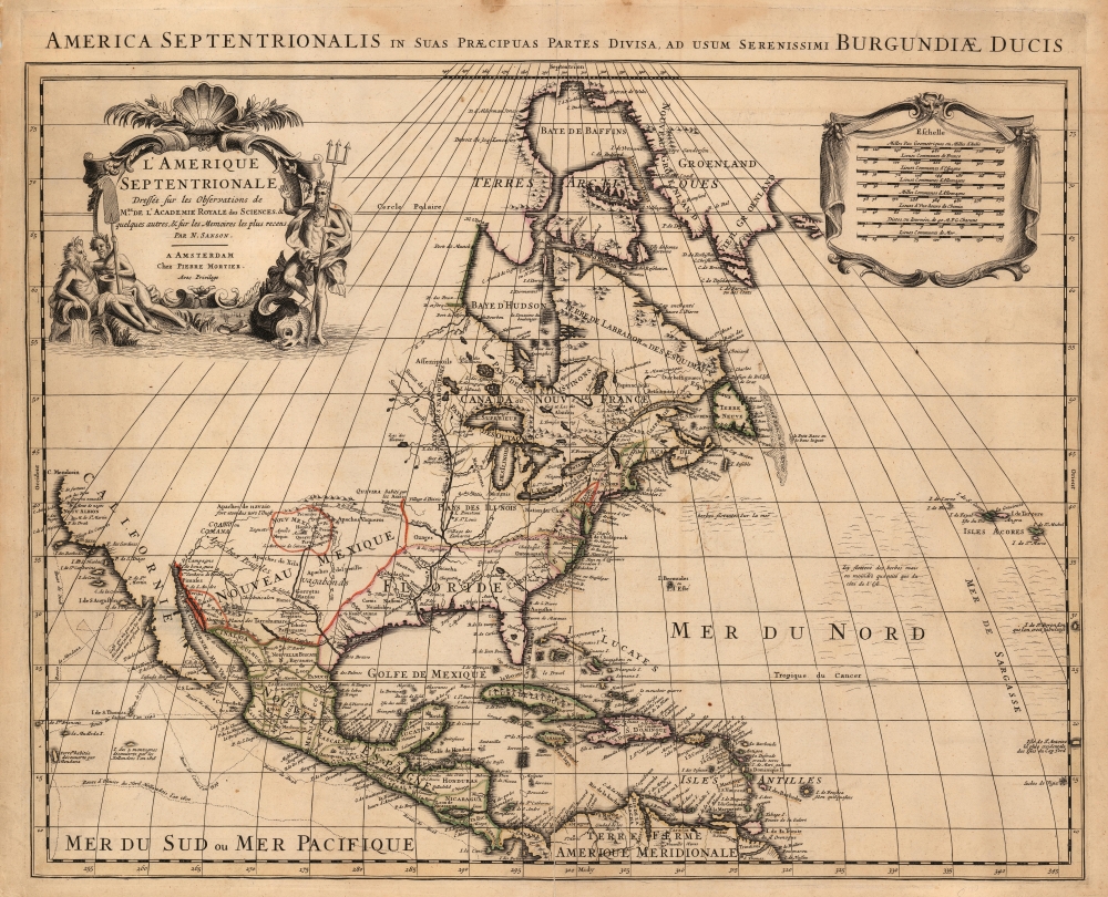
America Septentrionalis in suas Praecipuas Partes Divisa, Ad Usum Serenissimi Burgundiae Ducis/ L'Amerique Septentrionale Dressee sur les Observations de Mrs. de l'Academie Royale des Sciences et quelques autres, et sur les Memoires les plus recens Par N. Sanson.
1708 (undated) 18.25 x 23 in (46.355 x 58.42 cm) 1 : 19000000
1708 (undated) 18.25 x 23 in (46.355 x 58.42 cm) 1 : 19000000
Description
This is Peter Mortier's 1708 edition of De L'Isle's foundational 1700 mapping of North America. De l'Isle's map was the first to begin correcting the California-as-an-island myth, however tentatively. The map embraces North America from Baffin's Bay southwards as far as the Spanish Main, westwards to Cape Mendocino, and eastwards to include the Azores and the Sargasso Sea. Cartographically this map is faithful to the De L'Isle, differing mainly in the positioning of the title cartouche and the mileage scales.
Further north along the coast, San Diego, Seyo, Cape Mendocino, Francis Drakes Port, and the English claim of New Albion are noted. Both Mexico and New Mexico are mapped with sophistication, identifying mines, indigenous peoples, mountains, rivers, and the missions of Santa Fe, Taos, and San Antonio de Senecu (El Paso).
A Cautious Reassessment of California
This map is the first to retreat from the 17th century canard of insular California. True to form, the punctilious De l'Isle leaves the Pacific coast blank beyond Cape Mendocino, and he does not complete the coastline at the northern terminus of the Gulf of California. Thus, in the absence of direct evidence of the coastlines, De l'Isle makes no pronouncement: a more scientifically sound approach than the majority of the maps of this region from the preceding century. De l'Isle himself explained that he preferred to avoid premature conclusions on the uncertain matter,therefore I have made California neither an Island nor a part of the Continent, and I will stay with this point of view until I have seen something more positive than I have seen to date.On the west coast of California, a false bay is shown, with the French notation 'Gulf of which nothing has yet been discovered but the moderns believe to be very deep.' It is not clear which 'moderns' De l'Isle had in mind, although De Fer's maps showed a bay at this latitude nearly bisecting the island of California.
Further north along the coast, San Diego, Seyo, Cape Mendocino, Francis Drakes Port, and the English claim of New Albion are noted. Both Mexico and New Mexico are mapped with sophistication, identifying mines, indigenous peoples, mountains, rivers, and the missions of Santa Fe, Taos, and San Antonio de Senecu (El Paso).
A State-of-the-Art American Interior
The Mississippi Valley is well developed and based upon the most advanced French information available. The forts of St. Louis and Bon Secours are noted, as is the settlement of d'Iberville at Bilochy. The Great Lakes are beautifully drawn, largely following the Coronelli model. The concentration of French power in the region is evident with forts at Tadousac, Quebec, Sorel, Montreal, and Frontenac.A French North America
While De l'Isle was scientific and cautious in his expression of geographical detail, he was not so circumspect in his political statements. His delineations of the borders between French and English territories in the lands east of the Mississippi make it clear that De l'Isle considered England's empire in North America to be almost entirely coastal, confining the English colonies to a narrow strip of land east of the Alleghenies, and limited to the River and Fort of Kinibeki (Kennebec) at their northern border. Nevertheless, Boston, Nantucket, Long Island, Manhattan, New Jersey, Pennsylvania, Jamestown, Roanoke, Charlestown, and St. Augustine are identified along the eastern seaboard.Atlantic Details
At sea there are a couple of elements of note. This is the first printed mapping of the Sargasso Sea, here identified as the 'Mer de Sargasse' where 'Icy flottent des herbes mais en moindre quantité'. Along the Mexican and California coastline, the routes of various navigators, including Olivier, Cortez, Gaetan, Mendonza, and Francis Drake, are delineated.A Curious Apocryphal Island
Just to the east of Barbados, in the Antilles, a curious apocryphal island appears with the label 'I. de Fonseca selon Quelquesuns.' This island, which is here surrounded by dangerous rocks and reefs, appears in maps as early as Hondius' Americae Novissima Descriptio where it is identified as Y. de S. B. This island was also identified by M. Rochette with the label Galissioniere's Rock. Other ships, including the Rainbow, claim to have seen the island as late as 1822. De L'Isle was the first to give the map a definite name, Fonseca. Even so, with so few sightings, it disappeared from most maps issued in the 18th century. There is some speculation that discolored water occasionally discharged by the nearby Orinoco River led to various false sightings of land.Sanson?
A baffling feature of this map is its attribution, in the cartouche, to Nicolas Sanson - who had died in 1667, and whose geography for this region had been obsolete 20 years prior to De l'Isle's 1700 map. Sanson's known maps of North America bear no resemblace. Sanson was, in his day, a towering geographical authority, and his reputation was such that Peter Mortier's 1708 atlas (in which the present map was included) would be titled Atlas nouveau de diverses cartes choisies des Meilleurs geographes comme Sanson [New atlas of various maps chosen by the best geographers like Sanson]. It is possible that one of Mortier's engravers added Sanson's name inadvertently. Other examples of this map appearing in the same atlas present De l'Isle's name correctly. On the other hand, at the same time as this map was published, another Amsterdam publisher, Renard, was selling De l'Isle's map under his own imprint, and it is possible that Mortier used the spurious Sanson imprint in an effort to sneak this map past his competitor. Whatever the reason might be for Sanson's name, its presence has long confused map scholarship: for example, Philip Lee Phillips's catalog of the Lowery Collection lists this map (WL 145) under Sanson while acknowledging its later printing ascribed to De l'Isle in a later Covens and Mortier imprint.Publication History and Census
This map was engraved for Peter Mortier for inclusion in his 1708 Atlas Nouveau. It is one of the earliest derivatives of De l'Isle's 1700 map, which was also copied by Renard, Covens and Mortier, Schenk, Probst, and Ottens, as late as 1757. We see perhaps ten examples of this map with the De l'Isle imprint in institutional collections, but none with the spurious Sanson attribution. Despite this, we have seen examples come on the market from time to time.CartographerS
Guillaume De l’Isle (1675 - 1726) was a French cartographer, and arguably the finest mapmaker at the beginning of the eighteenth century. He was the son of Claude De L'Isle (1644 -1720), a Paris-based historian and geographer under Nicholas Sanson, then the leading light of French cartography. He was the chief proponent of the school of 'positive geography' and the primary figure defining the heights of the Golden Age of French Cartography. Guillaume's skill as a cartographer was so prodigious that he drew his first map at just nine years of age. He was tutored by J. D. Cassini in astronomy, science, mathematics and cartography. By applying these diverse disciplines to the vast stores of information provided by 18th century navigators, Guillaume created the technique that came to be known as 'scientific cartography', essentially an extension of Sanson's 'positive geography'. This revolutionary approach transformed the field of cartography and created a more accurate picture of the world. Among Guillaume's many firsts are the first naming of Texas, the first correct map of the Mississippi, the final rejection of the insular California fallacy, and the first identification of the correct longitudes of America. Stylistically De L'Isle also initiated important changes to the medium, eschewing the flamboyant Dutch style of the previous century in favor of a highly detailed yet still decorative approach that yielded map both beautiful and informative. Guillaume was elected to the French Academie Royale des Sciences at 27. Later, in 1718, he was also appointed 'Premier Geographe du Roi', an office created especially for him. De L'Isle personally financed the publication of most of his maps, hoping to make heavy royalties on their sales. Unfortunately he met an untimely death in 1728, leaving considerable debt and an impoverished child and widow. De L'Isle's publishing firm was taken over by his assistant, Phillipe Buache, who would also become his son in law. More by this mapmaker...
Pierre Mortier (January 26, 1661 - February 18, 1711) or Pieter Mortier was a cartographer, engraver, and print seller active in Amsterdam during the later 17th and early 18th centuries. Mortier, then known as Pieter, was born in Leiden. He relocated to Paris from 1681 to 1685, adopting the French name Pierre, which he retained throughout his career. While in France, he developed deep French connections by bringing sophisticated Dutch printing technology and experience to nascent French map publishers such as Guillaume De L'Isle (1675 - 1726), Alexis-Hubert Jaillot (c. 1632 - 1712), and Nicholas de Fer (1646 - 1720). Consequently, much of Mortier's business was built upon issuing embellished high quality editions of contemporary French maps - generally with the permissions of their original authors. In the greater context of global cartography, this was a significant advantage as most Dutch map publishes had, at this point, fallen into the miasma of reprinting their own outdated works. By contrast, the cartographers of France were producing the most accurate and up to date charts anywhere. Mortier's cartographic work culminated in the magnificent nautical atlas, Le Neptune Francois. He was awarded the Privilege, an early form of copyright, in 1690. Upon Pierre's death in 1711 this business was inherited by his widow. In 1721, his son Cornelius Mortier took over the day to day operation of the firm. Cornelius partnered with his brother-in-law Jean Covens to form one of history's great cartographic partnerships - Covens and Mortier - which continued to publish maps and atlases until about 1866. Learn More...
Source
Mortier, P., Atlas nouveau de diverses cartes choisies des Meilleurs geographes comme Sanson, (Amsterdam: Mortier) 1708.
Condition
Good. Centerfold mended. Few marginal mends not impacting printed image. Original outline color.
References
OCLC 26861083. Tooley, R. V. The Mapping of America p.19, #32.