This item has been sold, but you can get on the Waitlist to be notified if another example becomes available, or purchase a digital scan.
1766 Desnos and Brion Map of North America
NorthAmerica-desnos-1766$325.00

Title
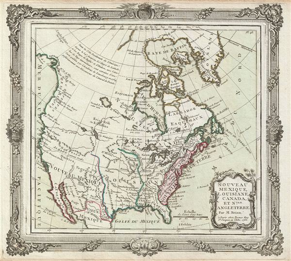
Nouveau Mexique, Louisiane, Canada, et Nlle. Angleterre.
1766 (dated) 11.7 x 12 in (29.718 x 30.48 cm)
1766 (dated) 11.7 x 12 in (29.718 x 30.48 cm)
Description
An appealing first edition issue of Brion de la Tour and Loius Charles Desnos' 1766 map of North America. Depicts North America according to the French conception with hopeful speculative river passages extending west from Hudson Bay towards Lake Winnepeg then along the mythical 'R. de L'Ouest' to the Pacific at the 'entree de Martin d'Aguilar' (likely the entrance to Columbia River). The main body of the map is divided into three sections, Nouveau Mexique, extending west of the Rio Grande, Louisiana between the Rio Grande, and the pre-Revolutionary period english Colonies along the eastern Seaboard. Nouveau Mexique includes the mythical kingdoms of gold, Quiviara and Toguayo (Teguyao), as well as more accurate indications for American Indian Tribes, missions, and riverways. Louisiana is divided into two regions, Floride, which contains all of the territory between the Appalachian Mountains and the Mississippi, and Louisiana proper extending westward to the Rio Grande (Rio Bravo), well into territory formally Claimed by Spain. The english Colonies (Nouvelle Angleterre) are relegated to a narrow region along the Atlantic coast bounded on the west by the Appalachian Mountains and completely excluded from access to the Great Lakes – a clear case of carto-advocacy for French dominance of the Fur trade in this region. Features Brion De la Tour's elaborate rococo border work and title cartouche. The earliest variant on this map was published in 1866 and varied only in that 'Nlle. Angleterre' was replaced with 'etats-Unis' in later editions. Prepared by Brion de la tour and published in Louis Charles Desnos' 'Geographie Moderne, Historique et Politique.'
CartographerS
Louis Charles Desnos (1725 - April 18, 1805) was an important 18th century instrument maker, cartographer and globe maker based in Paris, France. Desnos was born in Pont-Sainte-Maxence, Oise, France, the son of a cloth merchant. From April of 1745 he apprenticed at a metal foundry. Desnos married the widow of Nicolas Hardy, sone of the map, globe, and instrument seller Jacques Hardy. Desnos held the coveted position of Royal Globemaker to the King of Denmark, Christian VII, for which he received a stipend of 500 Livres annually. In return Desnos sent the King roughly 200 Livres worth of maps, books and atlases each year. As a publisher, Desnos produced a substantial corpus of work and is often associated with Zannoni and Louis Brion de la Tour (1756-1823). Despite or perhaps because of the sheer quantity of maps Desnos published he acquired a poor reputation among serious cartographic experts, who considered him undiscerning and unscrupulous regarding what he would and would not publish. Desnos consequently had a long history of legal battles with other Parisian cartographers and publishers of the period. It is said that he published everything set before him without regard to accuracy, veracity, or copyright law. Desnos maintained offices on Rue St. Jacques, Paris. More by this mapmaker...
Louis Brion de la Tour (1743 - 1803) was the Cartographer Royal to the King of France, his official title being Ingenieur-Geographe du Roi. Despite a prolific cartographic career and several important atlases to his name, little is actually known of his life and career. He may have been born in Bordeaux. His son of the same name was born in 1763 and published until his death in 1832. It is nearly impossible to distinguish the work of the father from the work of the son, as both used the same imprint and were active in roughly the same period. Much of their work was published in partnership Louis Charles Desnos (fl. 1750 - 1790). Their most notable work is generally regarded to be his 1766 Atlas General. Learn More...
Source
Brion de la Tour, L., Atlas General, Civil et Ecclesiastique, (Desnos, Paris) 1766.
Condition
Very good condition. Some edge toning. Blank on verso. Original centerfold.
References
Wheat, C. I., Mapping of the Transmississippi West, 1540 – 1861, #219. Sellers, John R. and Van Ee, Patricia, Maps and Charts of North America, # 117. Lowery, W., The Lowery Collection, #502.