This item has been sold, but you can get on the Waitlist to be notified if another example becomes available, or purchase a digital scan.
1785 Guthrie Map of North America
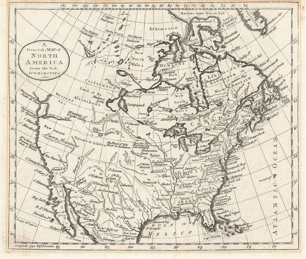
NorthAmerica-guthrie-1785$87.50

Title
A General Map of North America from the best Authorities.
1785 (undated) 8 x 9.5 in (20.32 x 24.13 cm) 1 : 29000000
1785 (undated) 8 x 9.5 in (20.32 x 24.13 cm) 1 : 29000000
Description
This is a c. 1785 William Guthrie map of North America that is based upon a c. 1770 Thomas Kitchin map of North America after the French and Indian War and before the American Revolution. Depicting the continent from the Pacific Ocean to the Atlantic Ocean and from Baffin's Bay to Mexico, and the Gulf of Mexico, the map provides an overview (although slightly flawed) of the state of affairs on the North American continent at the pivotal point in world history.
Global Context and Britain's North American Colonies
The French and Indian War, part of the larger global conflict between Great Britain and France known as the Seven Years' War, ended with the British in possession of France's Canadian colonies and France also ceded Britain all the land it occupied east of the Mississippi. The war also nearly doubled Great Britain's national debt, which the Crown sought to alleviate by taxing their American colonies. This choice, of course, ultimately led to the American Revolution. Since the French had ceded the territory east of the Mississippi to the British, Virginia, North Carolina, South Carolina, and Georgia are depicted as stretching from the Atlantic Ocean, where they had originally been founded, all the way to the Mississippi. Virginia is bounded by the Ohio River to the north, and New England, although jumbled, appears in mostly the correct configuration. Each colony is labeled and towns throughout the colonies are identified, including New York, Philadelphia, Boston, Williamsburg, Jamestown, and Augusta.Notations Outside the British Colonies
Moving west from Britain's Thirteen Colonies, All five Great Lakes are illustrated and labeled. French Louisiana is labeled. New Orleans is identified at the mouth of the Mississippi River, but no other French settlements are marked. American Indian tribes, such as the Miamis, and Osages are noted here, as are tribes that are identified as the 'Kansez' and the 'Black Padoucas'. One notation, near modern-day Nebraska, reads, 'Buffaloes. Meadows,' which is probably a fairly accurate description of the region at the time. Other intriguing notations are included in Louisiana, including one that reads 'Thus far the Mississipi has been ascended' and another 'The Head of this River is unknown,' in reference to the Missouri River.Spanish North America and the River of the West,
Kitchin's depiction of Spanish North America includes the provinces of New Mexico, New Biscay, and New Navarre, and labels Santa Fe, now in present-day New Mexico. The rest of the western portion of North America is strikingly blank, apparently unclaimed by any of these world powers. Francis Drake's New Albion is identified, although no borders are proposed for this English colony. New Albion is bracketed by 'snowy mountains' on the bottom and the 'River of the West' on top. The River of the West, as it is labeled here, was the mythical water route across North America from the Atlantic Ocean to the Pacific Ocean that innumerable adventurers and explorers had sought for centuries. Here, this long hunted-for dream is depicted emptying into the Pacific, but never quite connected to any of the rivers flowing to the east.Teguayo and Quivira
Between New Albion and Louisiana, two cities, Teguayo and Quivira are referenced. These cities are part of what have become known as the Seven Cities of Gold. Teguayo and Quivira, along with Cibola, Totonte, Axa, and Granata, were legendary wondrous cities said to have been built by seven bishops who fled Porto in the 8th century after the Moors invaded. Legend has it that these bishops prayed for salvation and were each granted a refuge in the Atlantic in the form of a magical paradise, where each bishop founded a city. After Antilla was not discovered in the Atlantic, legends continued to push the cities further west, until they ended up in the unexplored territory north of Mexico. Years later, the gold and glory-seeking conquistador Hernando Coronado ploughed through the region with a massive army sacking several Zuni Pueblos (generally associated with Cibola) and a city on the Great Plains known as Quivira, but failed to find the gold he sought.Publication History
This map was created by William Guthrie and published G. G. J. and J. Robinson in a c. 1785 edition of Guthrie's A New Geographical, Historical, and Commercial Grammar for which Thomas Kitchin engraved numerous maps.CartographerS
William Guthrie (1708 - March 9, 1770) was a Scottish historian, journalist, and writer. Born in Brechin, he studied at Aberdeen University with the idea of becoming a parochial schoolmaster. Instead, in 1730, he elected to settle in London and try his hand at literature. He covered parliamentary debates f or the Gentleman's Magazine and soon earned a reputation for being a political writer. He published several scholarly works, including a History of England from the Invasion of Julius Caesar to 1688 in four volumes, and, most notably, his Geographical Historical, and Commercial Grammar. More by this mapmaker...
Thomas Kitchin (August 4, 1718 – June 23, 1784) was a London based engraver, cartographer, and publisher. He was born in London to a hat-dyer of the same name. At 14, Kitchin apprenticed under Emanuel Bowen, under whom he mastered the art of engraving. He married Bowen daughter, Sarah Bowen, and later inherited much of his preceptor's prosperous business. Their son, Thomas Bowen Kitchin, also an engraver joined the family business, which thereafter published in Thomas Kitchin and Son. From 1858 or so Kitchin was the engraver to the Duke of York, and from about 1773 acquired the title, 'Royal Hydrographer to King George III.' He is responsible for numerous maps published in the The Star, Gentleman's Magazine, and London Magazine, as well as partnering with, at various times, with Thomas Jefferys, Emmanuel Bowen, Thomas Hinton, Issac Tayor, Andrew Dury, John Rocque, Louis de la Rochette, and Alexander Hogg, among others. Kitchin passed his business on to his son, Thomas Bowen Kitchin, who continued to republish many of his maps well after his death. Kitchin's apprentices included George Rollos, Bryant Lodge, Thomas Bowen Kitchin, Samuel Turner Sparrow, John Page, and Francis Vivares. Learn More...
Condition
Very good. Even overall toning. Closed margin tears professionally repaired on verso. Blank on verso.
References
John Carter Brown Library D792 G984n.