1843 Johnston Map of North America with Republic of Texas
NorthAmerica-johnston-1843$950.00

Title
North America.
1843 (undated) 23.75 x 19.25 in (60.325 x 48.895 cm) 1 : 14900000
1843 (undated) 23.75 x 19.25 in (60.325 x 48.895 cm) 1 : 14900000
Description
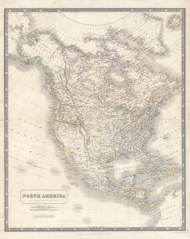
An illuminating 1843 map of North America by Alexander Keith Johnston that was published in the first edition of his important National Atlas. The most noticeable features of the map include an enlarged Republic of Texas, a British-friendly interpretation of the Pacific Northwest, and other geographic oddities in the American West.
A Closer Look
Stretching from the Arctic to Panama, this map takes in North and Central America, including much of the Caribbean. It is most notable for demonstrating the evolving boundaries of the region, especially the Republic of Texas and the disputed Pacific Northwest (discussed below). Additional points of interest include cartographic myths such as the Buenaventura River in the American West and the large Tule Lakes in California. It is also worth pointing out the notation of Native American groups in the central and western part of the continent, including the short-lived Indian districts, such as the 'Osage District,' which predated the establishment of territories. As Arctic exploration was still in its infancy, it is no surprise to see Greenland erroneously connected to the northernmost islands of Canada. The geography of Central America is likewise characteristic of the early-mid 1840s, with an independent Republic of Yucatán.Republic of Texas
The Republic of Texas came into existence after Texas declared independence from Mexico in 1836. Following the revolution, Texas claimed the Rio Grande River as its southern border. The surrender treaties were never ratified by Mexico and the Mexicans disputed the southern border, stating that it was not the Rio Grande, but the Nueces River that created the boundary between the two nations. Intermittent hostilities continued until Texas was admitted into the United States in 1846. This map highlights the uncertainty over the border at the time, with Texas displayed at its fullest extent, including portions stretching towards Chihuahua City, taking in Santa Fe, and reaching up towards the Rocky Mountains. A rump, undifferentiated portion of Mexico separates Texas from an unusually large Upper California at what is now New Mexico and Colorado.The Oregon Question
Another intriguing attribute of this map is that the Pacific Northwest border of the United States is not depicted at the 49th parallel, which is the contemporary border between the United States and Canada, but rather at the Columbia River, the current border between Oregon and Washington. The Oregon Question was disputed for decades between the United States and Great Britain. The basis for the disagreement was mostly economic; the fur trade in the Pacific Northwest was booming, which meant that both British and American companies and citizens wanted access to this area. American interest was also rooted in the concept of Manifest Destiny and Westward Expansion. Although the border was set at the 49th parallel by 1846, the crisis was not fully resolved until 1872. As 'Geographer to the Queen,' Johnston's loyalties were clearly with the most expansive British interpretation of the border.Publication History and Census
This map was drawn by Alexander Keith Johnston and published in 1843 in the first edition of The National Atlas of Historical, Commercial and Political Geography, a groundbreaking work of physical geography. A previous owner has penciled in '1857' at bottom-left, clearly mistaken given the features pointed out above. The map is independently cataloged in the holdings of about twenty institutions in the OCLC, though a precise census is difficult to establish given the intermingling of digital and physical examples.Cartographer
Alexander Keith Johnston (December 28, 1804 - July 9, 1871) was a Scottish cartographer and map publisher active in the middle portion of the 19th century. Johnson was born at Kirkhill, near Edinburgh, Scotland. He studied at the University of Edinburgh where he apprenticed as an engraver. Around 1826, in partnership with his brother William, he founded a cartographic printing and engraving firm with the imprint "W. and A. K. Johnston." Johnston made a name for himself in educational geography, publishing numerous maps for use in schools. His brother, William Johnston, eventually left the firm to pursue a career in politics, eventually becoming the Lord Provost of Edinburgh. Alexander's son, who would bear the same name, became a geographer and explorer, suffering an untimely death on the Royal Geographical Society's 1879 expedition to Lake Nyasa. More by this mapmaker...
Source
Johnston, A. K., The National Atlas of Historical, Commercial and Political Geography..., (Edinburgh: John Johnstone and W. and A. K. Johnston) 1843.
Condition
Very good. Wear along centerfold.
References
OCLC 39674612.