This item has been sold, but you can get on the Waitlist to be notified if another example becomes available, or purchase a digital scan.
1855 Jacob Monk Wall Map of North America and the United States
NorthAmerica-monk-1855$1,250.00

Title
New Map of that portion of North America exhibiting the United States and Territories, the Canadas, New Brunswick, Nova Scotia and Mexico, also, Central America and The West India Islands.
1855 (dated) 56 x 60 in (142.24 x 152.4 cm)
1855 (dated) 56 x 60 in (142.24 x 152.4 cm)
Description
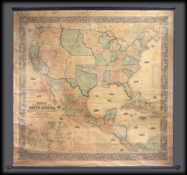
One of the most interesting and attractive 19th century wall maps of North America. Published in 1855 by Jacob Monk, this large and beautiful wall map, details much of North America from the southern border of Canada to Central America, the West Indies, and the northwestern parts of South America. Details the United States in full as well as parts of modern day Canada. Shows North America during an important period of territorial and cultural expansion following the Mexican-American war and during height of the California Gold Rush.
The California Gold Region around Sacramento, nestled between the Sierra Nevada's and the Coastal Ranges, is noted. Despite Monk's mention of the Gold Region it remains surprisingly inaccurate. Monk places Auburn well north of Sacramento between Marysville and Yuba City. Shows the western territories as they existed at the time with New Mexico extending from California to Texas, Utah reaching from California to Kansas, and Washington and Oregon extending eastward to Nebraska Territory. Nebraska Territory itself is shown at its fullest extent from Kansas to the border with British America (Canada). Oklahoma is divided up among three American Indian Nations, the Chah-Lah-Kee, the Muscogee, and the Chah-Ta. Also names numerous other American Indian tribes throughout. Shows several wagon routes and proposed railroads, as well as springs, mountain passes, forests, swamps, and deserts. Attempts to illustrate the shipping lanes along both the east and west coasts with numerous vignettes showing sailing ships. A large inset map in the lower left quadrant shows the world on a Mercator Projection. To the right of this is a chart detailing the towns and counties of the United States. Surrounded by an elaborate decorative border with a flora motif and decorative corner vignettes – a major upgrade over earlier editions.
This is the fourth state of Monk's map which was first published in 1854. All in all an extremely beautiful and interesting wall map of North America. This is the kind of map that can stand up to lengthy perusal.
CartographerS
Jacob Monk (August 25, 1805 - October 8, 1893) was a Baltimore and Philadelphia based American publisher of wall, pocket, and case format maps active in the mid-19th century. Monk was born in Stoughton, Massachusetts. It is not clear when he moved to Philadelphia, but he was active there from about 1850, when he began a lucrative publishing career, to 1857, or so. By the standards of American map publishers, Monk was exceedingly successful due to his strategy of employing a national network of door-to-door salesmen to promote and sell his wall map. Monk maps, thus, are in general more widely distributed than those of his competitors. He married New Yorker Charlotte M. French (Monk; 1823 - 1903) around 1851. He is also the founder, in 1856, of the Mount Vernon Cemetery. Sometime in the 1860s, Monk acquired some 44 acres of land on the Schuylkill River, just outside of Philadelphia, setting himself up as a gentleman farmer. More by this mapmaker...
August Hoen and Company (fl. c. 1840 - 1981) was a Baltimore based engraving and lithography firm active in the middle part of the 19th century. A. Hoen and Co. was originally founded by Edward Weber under the name 'E. Weber and Company.' Weber died in the early 1850s and his company was taken over by German immigrant August Hoen (18?? - 1886) and his brothers, Henry and Ernest Hoen. As general interest lithographers, the Hoen firm's corpus includes posters, cigar boxes, sheet music covers, and posters as well as maps. They are best known for their pioneering multi-color lithographic techniques. After the death of August Hoen, the business passed on to his son, Albert Hoen. Another son, Earnest A. Hoen, moved to Richmond, Virginia and opened a branch of the firm there where he was granted a charter to produce Civil War era Confederate Currency. Their contributions to the cartographic field are generally in association with engraving and printing work done for Jacob Monk and the U.S. Geological Survey. The Hoen family maintained an active interest in the firm for the next 100 years or so until it finally filed for bankruptcy in 1981. Learn More...
Condition
Good condition. Generally speaking this map is in great condition for a large unrestored wall map. No major stains or discolorations, no missing zones, and minimal crackling and whitening. Some tape repairs to edges. Partial restoration with contemporary edging. A great opportunity to own a Monk map with out the need to invest thousands of dollars in restoration, however, would also be an excellent candidate for restoration and should yield remarkable results.
References
Wheat, C. I., The Maps of the California Gold Region, 1848-1857, a Biblio-Cartography of an Important Decade, 243. Wheat, C. I., Mapping of the Transmississippi West, 1540-1861 (5 vols), 757 (1854 ed.) 794 (1853 ed.). Rumsey, 602.