This item has been sold, but you can get on the Waitlist to be notified if another example becomes available, or purchase a digital scan.
1812 Pinkerton Map of North America
NorthAmerica-pinkerton-1812$300.00

Title
North America.
1812 (dated) 20 x 28 in (50.8 x 71.12 cm) 1 : 16000000
1812 (dated) 20 x 28 in (50.8 x 71.12 cm) 1 : 16000000
Description
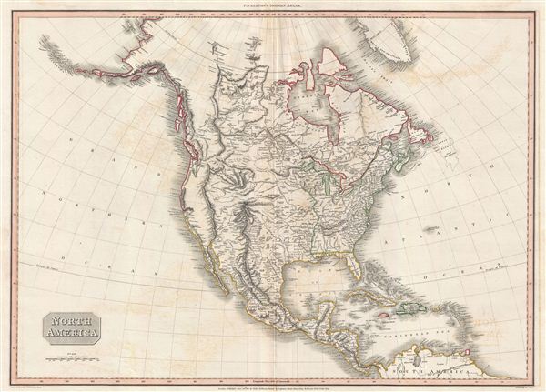
A scarce, beautiful, and exceptionally interesting example of John Pinkerton's stunning 1812 map of North America. The map covers all of North American, Central America, the Gulf of Mexico, and the Caribbean. It extends northwards as far as Greenland and Alaska, incorporating the full Hudson Bay, and southwards to the Spanish Main. Cartographically this map represents a notable attempt to combine cartographic speculation with new discoveries and political advocacy.
Drawn at the height of British - American hostilities related to the War of 1812, this map heavily advocates for British interests. Despite being issued in 1812, the western boundary of American terminates at the Mississippi River - a clear rejection of the 1803 Louisiana Purchase. There is a reason for this. By the turn on of the 19th century, it had become abundantly clear to everyone involved that the true wealth of North America lay in the fur trade, particularly the export of beaver pelts to the infinitely wealthy markets of Asia. By this time there were two forces in the fur trade, semi-independent American traders following in the footsteps of Lewis and Clark and British traders operating under the jurisdiction of the Hudson Bay Company, whose territorial monopoly they were actively extending towards the Pacific. The key to exploiting this region was control of the Columbia River, which provided an easy access point to the interior. The explorations of Lewis and Clark, as well as the acquisition of Louisiana and its tentative inclusion of the as yet unnamed Oregon region put the commercial ambitions of the Hudson Bay Company's Northwest Coast wing in jeopardy. Violent clashes between the Hudson Bay Company and American fur traders working in the region were common. Here Pinkerton advocates, via color coding, for British control of all of North America above San Francisco Bay and the Great Lakes. While there is no clear overland boundary demarcation between Lake Superior and the Pacific, due to lack of a true understanding of the territory, his intention is clear - to advocate for British interests in the Americas. It is interesting to compare this with the scarce and updated 1818 Philadelphia issue of this map which proactively illustrates American interests.
Beyond the political elements of this map, there are various cartographic elements of extreme interest. Pinkerton had particular difficulty reconciling the course of the Missouri River between conflicting accounts provided by the Welsh Hudson Bay Company explorer David Thomson and the American explorers Lewis and Clark. Both possible river courses are ghosted in, suggesting Pinkerton's unwillingness to advocate for either. The more northerly course is attributed to Thomson's 1798 explorations and reads 'North Bend according to Mr. Thompson 1798' and continues to become 'Course of the River Missouri according to former conjectures.' The more southerly route follows the explorations of Lewis and Clark and is identified as 'Course of the Missouri according to Captain Louis.'
The problem of the Missouri was further confused by a general misunderstanding of the Great Basin and the Rocky Mountains. Here Pinkerton attempts to accommodate conflicting reports by Pike, Soulard, and Humboldt. The southern extension of the Rocky Mountains roughly follows Humboldt's impressive 1811 map of the region. Humboldt however, never truly explored the region and based his work on archives in Mexico City containing not only reports from Spanish explorers and conquistadores but also indigenous geographic information. The result was an impressively accurate portrayal of the region that was nonetheless fundamentally flawed. The Great Basin is here rendered according to Humboldt's interpretation of the 1776 Dominguez-Escalante Expedition, which was the first recorded siting of the Great Salt Lake - here rendered embryonically. Pikes Peak is marked, but not identified, as the northern terminus of the Rocky Mountains. From here we can see the apocryphal River Buenaventura, in a nod to Humboldt, flowing into the embryonic Great Salt Lake. Pinkerton optimistically imagines the Missouri and the Platte Rivers extending westward through vast gaps in the Rocky Mountains to headwaters in the Sierra Nevada Range. South of the Great Basin and west of the Sierra Nevada, Pinkerton wisely either marks the territory as 'Unknown Parts' or simply leaves the map blank.
In the far north hopeful traces of the Northwest Passage remain, with the seas identified by Mackenzie and Hearne - likely the Dolphin and Union Strait - duly noted. In the late 18th century two transcontinental journeys, today little known, redefined the popular conception of the North American interior. These were the explorations of Samuel Hearne and Alexander MacKenzie, fur traders both, which, in search of profit and glory, separately penetrated the Canadian interior and in doing so became the first Europeans to see the Arctic Ocean from the shores of the North America. By traveling northward along an overland route from known territories, the work of these important explorers finally put an end to European ambitions for a Northwest Passage to the Pacific via inland waterways. Once news of their discoveries reached Europe, cartographers, including Pinkerton, were quick to update their charts, filling in a significant part of the Canadian Northwest and redefining the cartographic perspective of the region.
All in all this an important and often neglected map in this history of Transmississippi exploration. The map was drawn by L. Herbert and engraved by Samuel Neele under the direction of John Pinkerton. It was published in the 1813 edition of Pinkerton's Modern Atlas. It is noteworthy that the color work reflects publication for European audiences. Other issues with a more full color approach were intended for sale to other markets.
Cartographer
John Pinkerton (February 17, 1758 - March 10, 1826) was an Scottish writer, historian, and cartographer. Pinkerton was born in Edinburgh, Scotland. He was a studious youth with a passion for the classics. As a young man, he studied at Edinburgh University before apprenticing as a lawyer. Around this time, he began writing, with his first book, Elegy on Craigmillar Castle published in 1776. Pinkerton moved to London in 1781 to pursue his writing career in earnest. He successfully published several works of literature, poetry, and history. Pinkerton proved passionate in his literary and historical writings, but his correspondence with other cartographers has been labeled as aggressive, even insane. In addition to his work as a writer and historian, Pinkerton was one of the leading masters of the Edinburgh school of cartography which flourished from roughly 1800 to 1830. Pinkerton and his contemporaries (Thomson and Cary) redefined European cartography by abandoning typical 18th century decorative elements such as elaborate title cartouches and fantastical beasts in favor of detail and accuracy. Pinkerton's principle work is Pinkerton's Modern Atlas published from 1808 through 1815 with a special American reissue by Dobson and Co. in 1818. Pinkerton relocated to Paris in 1818, where he managed his publishing business until his death in 1826. More by this mapmaker...
Source
Pinkerton, John, A modern atlas, from the latest and best authorities, exhibiting the various divisions of the world, with its chief empires, kingdoms and states, in sixty maps, carefully reduced from the largest and most authentic sources, (London: Cadell & Davies, Longman Hurst Rees, & Orme) 1813
Condition
Very good. Original centerfold. Else clean.
References
Wheat, C. I., Mapping of the Transmississippi West, 1540 - 1861, 311. Rumsey 0732.042 (1812).