This item has been sold, but you can get on the Waitlist to be notified if another example becomes available, or purchase a digital scan.
1818 Pinkerton Map of North America
NorthAmerica-pinkerton-1818$325.00

Title
North America.
1818 (undated) 21 x 28 in (53.34 x 71.12 cm)
1818 (undated) 21 x 28 in (53.34 x 71.12 cm)
Description
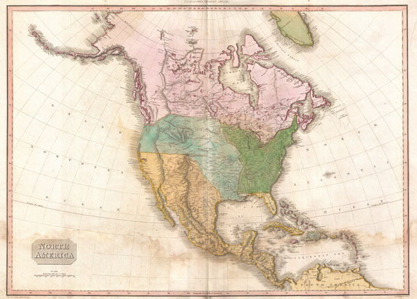
This is an extremely unusual mapping of North America prepared for the 1818 American edition of Pinkerton's Atlas. Although the basic engraving remains identical to Pinkerton's Atlas of 1813, published in London, the coloration has been updated to reflect American sensibilities. Where the British edition leaves the borders in the northwest somewhat vague, this edition draws a specific line roughly along the 50th parallel that descends at an angle west of the Rockies to meet the sea around Mt. Rainier. Further, while the London edition attributes Spanish dominion to all lands west of the Mississippi, this edition identifies Louisiana west of the Red River and south of the 40th parallel. Cartographically Pinkerton's map presents a curious amalgam of Soulard, Escalante, Pike and Lewis and Clark. Wheat suggests that Pinkerton struggled to reconcile conflicting reports from Soulard and Pike, particularly in the Missouri Basin. He introduces the curious convention of showing a dashed line noting the route of the Missouri River 'according to former conjectures.' Further to the south he notes the path of the Missouri according to M. Lewis. The great basin is particularly vague, with the Great Salt Lake, or rather an embryonic version of it, appearing much further west than is common. It also shows the apocryphal Buenaventura river flowing into the lake from the mountains in the northeast. Pikes Peak appears, but is not named. Florida is attached to the Spanish dominions. We are not certain to whom to ascribe the variations of coloring apparent on this map as we have not been able to compare it with a similar map from the rare 1818 edition, which has proven extremely elusive. In the far north hopeful traces of the Northwest Passage remain, with the seas identified by Mackenzie and Hearne - likely the Dolphin and Union Strait - duly noted. Greenland is also, in a curiously advanced step forward , detached from the mainland.
Drawn by L. Herbert and engraved by Samuel Neele under the direction of John Pinkerton. This particular edition further recognizes Bradford & Inskeep and Moses Thomas, an important Philadelphia scholar and author of several important works on Lewis and Clark. This map comes from the scarce American edition of Pinkerton's Modern Atlas, published by Thomas Dobson & Co. of Philadelphia in 1818.
Drawn by L. Herbert and engraved by Samuel Neele under the direction of John Pinkerton. This particular edition further recognizes Bradford & Inskeep and Moses Thomas, an important Philadelphia scholar and author of several important works on Lewis and Clark. This map comes from the scarce American edition of Pinkerton's Modern Atlas, published by Thomas Dobson & Co. of Philadelphia in 1818.
CartographerS
John Pinkerton (February 17, 1758 - March 10, 1826) was an Scottish writer, historian, and cartographer. Pinkerton was born in Edinburgh, Scotland. He was a studious youth with a passion for the classics. As a young man, he studied at Edinburgh University before apprenticing as a lawyer. Around this time, he began writing, with his first book, Elegy on Craigmillar Castle published in 1776. Pinkerton moved to London in 1781 to pursue his writing career in earnest. He successfully published several works of literature, poetry, and history. Pinkerton proved passionate in his literary and historical writings, but his correspondence with other cartographers has been labeled as aggressive, even insane. In addition to his work as a writer and historian, Pinkerton was one of the leading masters of the Edinburgh school of cartography which flourished from roughly 1800 to 1830. Pinkerton and his contemporaries (Thomson and Cary) redefined European cartography by abandoning typical 18th century decorative elements such as elaborate title cartouches and fantastical beasts in favor of detail and accuracy. Pinkerton's principle work is Pinkerton's Modern Atlas published from 1808 through 1815 with a special American reissue by Dobson and Co. in 1818. Pinkerton relocated to Paris in 1818, where he managed his publishing business until his death in 1826. More by this mapmaker...
Thomas Dobson (1751 - 1823) was an American publisher active in Philadelphia during the late 18th and early 19th centuries. Dobson was born in Edinburgh, Scotland in 1751 and emigrated to Philadelphia c. 1780. In Philadelphia, he established a successful printing business by republishing edited and updated versions of important British reference materials in matching quality but at a much lower price point. He is best known for publishing the first American edition of the Encyclopedia Britannica. He also published America's first Hebrew Bible. Cartographically Dobson's most notable work is 1818 republication of Pinkerton's fantastic Modern Atlas. Learn More...
Source
Pinkerton, J., A Modern Atlas, from the Lates and Best Authorities, Exhibiting the Various Divisions of the World with its chief Empires, Kingdoms, and States; in Sixty Maps, carefully reduced from the Larges and Most Authentic Sources. 1818, Philadelphia, Thomas Dobson Edition.
Condition
Good. Minor dampstaining in the lower quadrants. Else clean. Blank on verso.
References
Rumsey 0732.042 (British edition). Phillips (Atlases) 724. National Maritime Museum, 409. Phillips (America), p.597. Wheat, Carl Irving, Mapping the Transmississippi West, 1540-1861 (5 vols), 311.