
1777 Sayer / Bennett Wall Map of North America - First 'Pownall' Edition

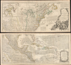
A New and Correct Map of North America, with the West India Islands...
Fallout of the French and Indian War.
- Digital Map Information
- Suitable for large format printing
- File Size: 129.89 MB
- File Type: ZIP / TIFF
- ICC color profile embedded
- Delivered instantly via download link
Fallout of the French and Indian War.
This is the 1777 edition of Robert Sayer and John Bennet's two-sheet wall map of North America, published near the start of the American Revolutionary War (1775 - 1783). It is the first 'Pownall' edition of the map, incorporating new surveys and information on the American interior, providing a comprehensive overview of the continent in the aftermath of the French and Indian War.A Closer Look
The map covers the eastern and central portion of North America from James Bay (the southern portion of Hudson Bay), extending southwards to the northernmost portion of South America. Colonial territories of several empires are outlined in hand color. In the future United States of America, Virginia, the Carolinas, and Georgia are traced without a western boundary, reflecting their still uncertain limits. A note to the east of Chesapeake Bay explains that even the borders that are traced between the British American colonies are not fully settled.Waterways are labeled in considerable detail, while roads, 'trading paths,' towns, forts, portages, trading posts or factories, Indian villages, mines, and other features are recorded throughout. Explanatory notes appear periodically, discussing the history of local Indians, points of geography, or taking digs at the French ('Cape of Port Rich is designedly omitted in all late French Maps and Charts, because it sets Bounds to their fishing…').Perhaps the most notable feature of the map is the meticulous naming of Native American groups on the frontier of the British colonies of North America, and beyond. These included not only groups with which the British had had extensive interactions, such as the Iroquois, or even groups familiar to the French (around the Great Lakes) and the Spanish (in today's American Southwest), but even groups on the Plains ('Great Meadows') such as the 'Kansez Nation' and 'Ozages Nation' with whom Europeans had little to no direct interaction.
At sea, information is provided on currents, hazards, shoals, and passable routes, including the routes of Spanish galleons from Mexico to Spain. Two inset maps appear, one at top-left covering Baffin Bay to Hudson Bay with a presumed land bridge between Canada and Greenland, and one at bottom-left of the Gulf of California, with reference to Sir Francis Drake, Father Kino, and the Insular California myth. Longitude is measured from both London and Ferro. Elaborate cartouches frame the title on the top sheet, with depictions of Native Americans, and seven scales with a legend on the bottom sheet. Perhaps most noticeable of all, the text of several articles of the 1763 Treaty of Paris ending the French and Indian War (Seven Years' War) are included at right.
Historical Context
This map was initially prepared in the aftermath of the French and Indian War (Seven Years' War; 1754 - 1763), when Britain managed to gain the advantage against France in a global colonial competition, though at great financial cost. The costs of the Seven Years' War ultimately contributed to both the American and French Revolutions, as both the British and French crowns struggled to pay for the bruising conflict.Britain had been granted lands up to the Mississippi River by the Treaty of Paris, but most of the newly acquired territory was dominated by powerful Native American nations. Less than three months after the signature of the Treaty of Paris, Pontiac's Rebellion broke out throughout the Great Lakes region. Partly in response to the rebellion, King George III (unsuccessfully) forbade new settlements west of the Appalachian Mountains in the (October) 1763 Royal Proclamation, another gripe the colonists levied at him when they declared independence. In this fraught situation, knowledge of the interior of the continent and the peoples residing therein was essential for the British Crown, Members of Parliament, and other grandees. Drawing on the most recent updates (discussed below), this map was among the first to provide such information in detail in the aftermath of the French and Indian War.
Publication History and Census
This map is ultimately derived from a 1765 map by Emanuel Bowen and John Gibson, which was then updated (especially to reflect the results of the French and Indian War / Seven Years' War) and included in atlases published by William Faden, Thomas Jefferys, and Sayer (later Sayer and Bennett). The present map represents the first 'Pownall' edition of the map, referring to the British colonial governor, Member of Parliament, and sometimes cartographer Thomas Pownall (1722 - 1805). In 1755, while in Philadelphia, Pownall had collaborated with cartographer Lewis Evans (c. 1700 - 1756) to produce a much improved map of the interior regions of the American colonies (titled 'A Map of the Middle British Colonies in North America' but more often known as the 'Evans-Pownall map'), which is considered, along with the Mitchell map, to be of paramount importance for the 18th century cartography of North America. Pownall published an updated, second edition of the map in 1776, the results of which were then incorporated by Sayer and Bennett into the present map.The present map first appeared in a rare edition of Jefferys' American Atlas published by Sayer and Bennett and dated 1776 though including this dated 1777 map (Library of Congress Call No. G1100 .J4 1777). It was then included in a 1778 issue of the American Atlas with the same date on the map (February 15, 1777) before a second state dated 1779 was included in subsequent editions of the atlas.
The present map, the first state of the 'Pownall' map, is independently cataloged at roughly ten institutions worldwide in the OCLC.
Cartographers
Robert Sayer (1725 - January 29, 1794) was an important English map publisher and engraver active from the mid to late 18th century. Sayer was born in Sunderland, England, in 1725. He may have clerked as a young man with the Bank of England, but this is unclear. His brother, James Sayer, married Mary Overton, daughter-in-law of John Overton and widow of Philip Overton. Sayer initially worked under Mary Overton, but by December of 1748 was managing the Overton enterprise and gradually took it over, transitioning the plates to his own name. When Thomas Jefferys went bankrupt in 1766, Sayer offered financial assistance to help him stay in business and, in this way, acquired rights to many of the important Jefferys map plates as well as his unpublished research. From about 1774, he began publishing with his apprentice, John Bennett (fl. 1770 - 1784), as Sayer and Bennett, but the partnership was not formalized until 1777. Bennett retired in 1784 following a mental collapse and the imprint reverted to Robert Sayer. From 1790, Sayer added Robert Laurie and James Whittle to his enterprise, renaming the firm Robert Sayer and Company. Ultimately, Laurie and Whittle partnered to take over his firm. Sayer retired to Bath, where, after a long illness, he died. During most of his career, Sayer was based at 53 Fleet Street, London. His work is particularly significant for its publication of many British maps relating to the American Revolutionary War. Unlike many map makers of his generation, Sayer was a good businessman and left a personal fortune and great estate to his son, James Sayer, who never worked in the publishing business. Further Details...
John Bennett (1746 - December 8, 1787) was an English map publisher. He was born in Derbyshire, the son of Tideswell shoemaker Samuel Bennett. He moved to London around 1761 to take work as a servant to the mapmaker Robert Sayer (1725 - 1794). In 1765, he became Sayer's formal apprentice. Bennett entered the Free Stationers guild on June 7, 1774. Bennett and Sayer continued to work together on the understanding that, in time, Bennett would acquire equity in the firm. This occurred in 1777, when the firm was renamed 'Sayer and Bennett'. For the next several years, they ran one of the most prolific map and printmaking firms in Europe. Bennett began to show signs of mental instability around 1781 and by 1783, was admitted to an asylum in Clapton. The causes are unknown, but mercury poising is a real possibility. Sayer petitioned to dissolve the partnership in 1784 and by 1785 there are no further publications bearing the 'Bennett' imprint. He died in Islington in 1787. Further Details...
Thomas Pownall (1722 - February 5, 1805) was a British scholar, statesman and soldier active in the colonial administration of North America just prior to the American Revolutionary War. Pownell was born in England and educated at Trinity College, Cambridge. After graduation he was employed by his brother, John Pownall, at the office of the Lord's Commissioners of Trade and Plantations, which oversaw British economic interests in its North American colonies. In 1753, Pownall was appointed secretary to the governor of New York, Sir Danvers Osborne. Osborne, himself having be only recently appointed to the position, committed suicide shortly after taking office. Despite this setback, Pownall remained in America and devoted himself to studying and researching the colonies. In the process Pownall became close lifelong friends with Benjamin Franklin and other New World luminaries. He also published several notable works on the colonial administration of North America. In 1757 Pownall was appointed Governor of the Massachusetts Bay colony. In this position he frequently found himself at odds with the restrictive policies of the Board of Trade. It was not long before he was pushed out of office and, declining the governorship of Jamaica, reassigned to South Carolina. Despite nominally holding the governorship of South Carolina, Pownall never visited the colony. Instead he returned to England where he eventually became a member of Parliament. In Parliament, he advocated for reduced taxes towards the colonies - had he been heeded, the American Revolution may have never happened. Pownall retired from public life around 1780, but continued to pursue his scholarly interests. Pownall's research contributed significantly to several important maps and scholarly work on North America. Further Details...
Thomas Jefferys (1695 - November 20, 1771) was one of the most prominent and prolific map publishers and engravers of his day. Jefferys was born in Birmingham and was apprenticed to the engraver Emmanuel Bowen in 1735. Later, in the 1740s he engraved several maps for the popular periodical Gentleman's Magazine. Around 1740 Jefferys was finally able to go into business for himself and in 1746 received an appointment as 'Geographer to Fredrick, Prince of Wales,' which shortly after translated to the position of 'Royal Cartographer to King George III.' Jefferys initially specialized in compiling and re-engraving the works of earlier cartographers into more coherent cartographic wholes. Later, while not salaried position, Jefferys' appointment as 'Royal Cartographer' guaranteed preferential access to the most up to date cartographic material available, allowing him to produce new and updated charts of exceptional accuracy. He his best known for his maps of the Americas, particularly the posthumously published 1775 American Atlas, which included some of the finest and most important late colonial era maps of America ever made. Despite his prolific publishing history, royal appointments, and international publishing fame, Jefferys lived most of his life in dire economic straits. He was bailed out of bankruptcy by Robert Sayer during the production of the American Atlas. In the end, Jefferys died suddenly with very little to his name. Nonetheless, his cartographic legacy survived, and even after his death in 1771, many of his important maps continued to be published and republished by Sayer and Bennet, Conrad Lotter, Georges Louis Le Rouge, Laurie and Whittle, and others. Many attribute some of Jefferys best maps to the colorful and criminally inclined Irish cartographic genius Braddock Mead (John Green, c. 1688 - 1757), who is considered the 'secret behind Jefferys.' Jefferys was succeeded by his son, also Thomas, who had little success as a cartographer and eventually partnered with, then sold his stock and plates to William Faden - Jefferys' true heir. Further Details...
Source
Jefferys, T., The American Atlas: Or, A Geographical Description Of The Whole Continent Of America ... Engraved On Forty-Eight Copper Plates, By The Late Mr. Thomas Jefferys, Geographer to the King, and Others, (London: Sayer and Bennett) 1776.
Thomas Jefferys' The American Atlas is among the most important atlases of American issued during and after the American Revolutionary War (1775 - 1783). Burden calls it 'arguably the first American 'state' atlas' and Ristow writes, it is a '… major cartographic reference work it was very likely consulted by American, English and French civilian administrators and military officers during the Revolution…' It was first published in 1775, with updates following in 1776, 1778, 1782, 1794, and 1800. All editions are notably postdate Jefferys himself, who died in 1771. The application of his name to the The American Atlas is mostly an honorific - though most of the constituent maps can be traced to Jefferys' work. After Jefferys' death, his map plates were acquired by his partner, printseller Robert Sayer. By the mid-1770s Sayer had taken on John Bennett as a partner. Together, they compiled and updated many of Jefferys' map, published as the to capitalize on interest in America associated with the Revolution. Maps from the The American Atlas exhbit is considerable date variation, with some featuring dates later than the title page, suggesting that many were updated by owners in subsequent years, and/or that the title page was reused for latter editions.
Condition
Very good. Slight wear on original fold lines.
References
OCLC 747839892 et al. Stevens, H. and Tree, R., 'Comparative Cartography of North America during the Early Eighteenth Century' (London: Comparative Cartography Map Collectors' Circle No. 39) 1967, 49.