1848 Stieler Map of North America
NorthAmerica-stieler-1848$450.00

Title
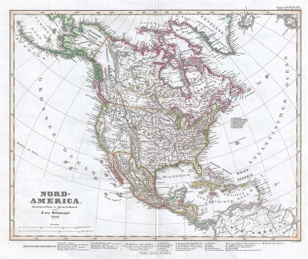
Nord-America. Entworfen u. gezeichnet von F. von Stulpnagel. 1848.
1848 (dated) 13.5 x 16 in (34.29 x 40.64 cm) 1 : 24000000
1848 (dated) 13.5 x 16 in (34.29 x 40.64 cm) 1 : 24000000
Description
This is an 1848 Adolf Stieler map of North America just after the Mexican-American War and near the beginning of the California Gold Rush. It also features a depiction of Texas at its largest, with boundaries extending westward well into modern day New Mexico and north along the Colorado River into modern day Wyoming. This configuration existed only briefly after Texas's 1845 annexation and the end of the Mexican-American War (1846 - 1848). The map illustrates the continent from the Pacific Ocean to Ireland and from the Arctic Ocean and Greenland to northern South America. Created at a pivotal moment in the history of the United States, the most intriguing part of this map is its informative cartographic representation of the American West. The borders of the areas labeled Wisconsin, Iowa, Indian Territory, Missouri Territory, and Oregon Territory are speculative at best, and, to a modern eye, hint at a lack of information. However, even with the inaccuracies with regard to territorial borders and names, numerous forts, rivers, towns, and physical features are labeled throughout the region, and the continent as a whole, giving the map an air of unimpeachable certainty. New California is labeled in the southwestern portion of the United States, as it had not yet been broken into smaller territories. All of the eastern states are labeled, along with their capitals, except for the smaller New England states, which are identified numerically and correspond to a key off to their right in the Atlantic Ocean. Indian tribes are referenced throughout, from the Arctic Ocean to Mexico. Twenty-one locations in Canada are identified by number and correspond with a key along the bottom border.
This map was created by Adolph Stieler and published by Justus Perthes in 1848.
This map was created by Adolph Stieler and published by Justus Perthes in 1848.
CartographerS
Adolf Stieler (1775 – 1836) was a German cartographer who worked most of his life in the Justus Perthes Geographical Institute in Gotha. His atlases are deservedly held in high esteem for their excellence. His Handatlas was the leading German world atlas until the middle of the 20th century, parts of which were printed until 1944. More by this mapmaker...
Johan Georg Justus Perthes (September 11, 1749 - May 2, 1816) was one of the most important German cartographic engravers of the 19th century. He was born in the Thuringian town of Rudolstadt, the son of a court physician. In 1778, he began working as a bookseller in Gotha. Perthes began his publishing empire shortly thereafter with the 1784 issue of the famed survey of European nobility known as the Almanac de Gotha. In the next year, 1785, he founded the cartographic firm of Justus Perthes Geographische Anstalt Gotha. His son Wilhelm Perthes (1793 - 1853) joined the firm in 1814. Wilhelm had prior publishing experience at the firm of Justus Perthes' nephew, Friedrich Christoph Perthes, who ran a publishing house in Hamburg. After Justus Perthes died in 1816, Wilhelm took charge and laid the groundwork for the firm to become a cartographic publishing titan. From 1817 to 1890. the Perthes firm issued thousands of maps and more than 20 different atlases. Along with the visionary editors Hermann Berghaus (1797 - 1884), Adolph Stieler (1775 - 1836), and Karl Spruner (1803 - 1892), the Perthes firm pioneered the Hand Atlas. When Wilhelm retired, management of the firm passed to his son, Bernhardt Wilhelm Perthes (1821 – 1857). Bernhardt brought on the cartographic geniuses August Heinrich Peterman (1822 - 1878) and Bruno Hassenstein (1839 - 1902). The firm was subsequently passed to a fourth generation in the form of Berhanrd Perthes (1858 – 1919), Bernhard Wilhelm's son. The firm continued in the family until 1953 when, being in East Germany, it was nationalized and run as a state-owned enterprise as VEB Hermann Haack Geographisch-Kartographische Anstalt Gotha. The Justus family, led by Joachim Justus Perthes and his son Wolf-Jürgen Perthes, relocated to Darmstadt where they founded the Justus Perthes Geographische Verlagsanstalt Darmstadt. Learn More...
Condition
Very good. Even overall toning. Light wear along original centerfold. Blank on verso.
References
OCLC 78137144.