1814 Thomson Map of North America
NorthAmerica-thomson-1814-2$500.00

Title
North America.
1814 (dated) 20 x 24 in (50.8 x 60.96 cm) 1 : 14000000
1814 (dated) 20 x 24 in (50.8 x 60.96 cm) 1 : 14000000
Description
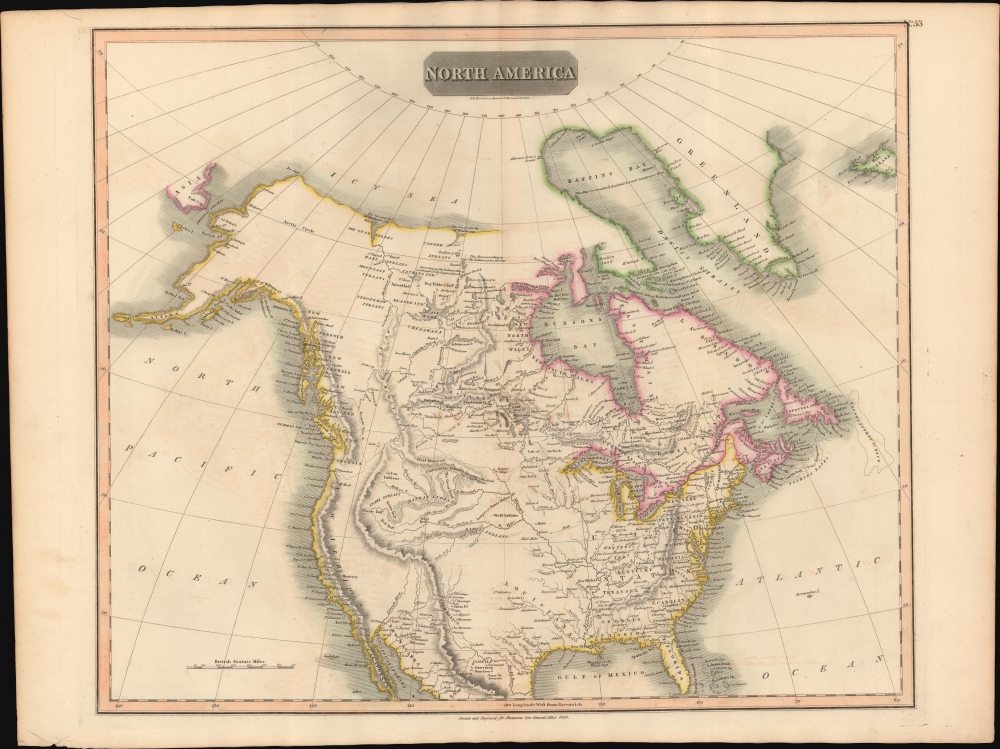
This is John Thomson's 1814 map of North America. It is perhaps the best general atlas map of North America to appear in the 19th century.
The Transmississippi is, by contrast, only sparsely mapped in accordance with the 1811 cartographic speculations of Alexander von Humboldt, especially his remarkable treatment of the Rocky Mountains, compounded by relatively limited information drawn from the just published journals of the Louis and Clark Expedition. Curiously neither Great Salt Lake nor Utah Lake are anywhere in evidence despite being mapped in some of Thomson's other maps of the region, such as his Spanish North America plate. Another curiosity is the interesting path commencing at the confluence of the Oisconsin and Mississippi Rivers and running east nearly to the Missouri - its source and purpose are a mystery. In a clear case of carto-advocacy Thomson has attached the name New Albion to the entire western coast from Vancouver Island to the Gulf of California, thereby asserting a British claim to the region dating to Drake's 16th century circumnavigation.
A Closer Look
Coverage extends from the Arctic south to southern of Florida and northern Mexico. Cartographically Thomson draws heavily from the explorations of Samuel Herne, Alexander MacKenzie, Louis and Clark, David Thomson, and others. This map offers impressive detail both with regard to those better-known parts of the United States located east of the Mississippi as well as in the British controlled provinces north of the Missouri River. The Great Lakes as well as many of the lakes and river to the west of the Hudson Bay are well mapped giving evidence to the work of French and British explorers seeking a river passage to the Pacific as well as to the exploratory efforts of the Northwest Company and the Hudson Bay Company.The Transmississippi is, by contrast, only sparsely mapped in accordance with the 1811 cartographic speculations of Alexander von Humboldt, especially his remarkable treatment of the Rocky Mountains, compounded by relatively limited information drawn from the just published journals of the Louis and Clark Expedition. Curiously neither Great Salt Lake nor Utah Lake are anywhere in evidence despite being mapped in some of Thomson's other maps of the region, such as his Spanish North America plate. Another curiosity is the interesting path commencing at the confluence of the Oisconsin and Mississippi Rivers and running east nearly to the Missouri - its source and purpose are a mystery. In a clear case of carto-advocacy Thomson has attached the name New Albion to the entire western coast from Vancouver Island to the Gulf of California, thereby asserting a British claim to the region dating to Drake's 16th century circumnavigation.
Publication History and Census
This is the 1814 first edition of Thomson's map from the 1817 first edition of the New General Atlas. Subsequent editions were published through 1826.Cartographer
John Thomson (1777 - c. 1841) was a Scottish cartographer, publisher, and bookbinder active in Edinburgh during the early part of the 19th century. Thomson apprenticed under Edinburgh bookbinder Robert Alison. After his apprenticeship, he briefly went into business with Abraham Thomson. Later, the two parted ways, John Thomson segueing into maps and Abraham Thomson taking over the bookbinding portion of the business. Thomson is generally one of the leading publishers in the Edinburgh school of cartography, which flourished from roughly 1800 to 1830. Thomson and his contemporaries (Pinkerton and Cary) redefined European cartography by abandoning typical 18th-century decorative elements such as elaborate title cartouches and fantastic beasts in favor of detail and accuracy. Thomson's principle works include Thomson's New General Atlas, published from 1814 to 1821, the New Classical and Historical Atlas of 1829, and his 1830 Atlas of Scotland. The Atlas of Scotland, a work of groundbreaking detail and dedication, would eventually bankrupt the Thomson firm in 1830, at which time their plates were sequestered by the court. The firm partially recovered in the subsequent year, allowing Thomson to reclaim his printing plates in 1831, but filed again for bankruptcy in 1835, at which time most of his printing plates were sold to A. K. Johnston and Company. There is some suggestion that he continued to work as a bookbinder until 1841. Today, Thomson maps are becoming increasingly rare as they are highly admired for their impressive size, vivid hand coloration, and superb detail. More by this mapmaker...
Source
Thomson, J., A New General Atlas, (Edinburgh: Baldwin, Craddock, Joy) 1817.
Thomson's New General Atlas was first published in 1817 and continued to be published until about 1821. This is the first of Thomson's major cartographic works and the atlas for which is most celebrated. The New General Atlas follows in the Edinburgh School, which eschews excessive decoration in favor of a more minimalistic fact-based cartographic vision, as established by John Pinkerton, Laurie and Whittle, John Cary, and others in the previous decades. The maps are notable for their massive scale, heavy stock, elegant color work, and easy-to-read typefaces. Although the atlas stopped being published after 1821, Thomson continued to offer 'supplementary' maps that could be tipped into the atlas as late as 1830, when he declared bankruptcy. The maps in the Thomson Atlas were engraved by Thomas Clerk, William Dassauville, Nathaniel Rogers Hewitt, James Kirkwood, Robert Kirkwood, John Menzies, George Menzies, Edward Mitchell, John Moffatt, Samuel John Neele, Robert Scott, and James Wyld.
Condition
Very good condition. Some offsetting. Original centerfold.
References
Rumsey 1007.059 (1817 edition). Wheat, Carl Irving, Mapping the Transmississippi West, 1540-1861 (5 vols), #319.