This item has been sold, but you can get on the Waitlist to be notified if another example becomes available, or purchase a digital scan.
1868 Dirección de Hidrografía Chart of North Carolina Coast, Outer Banks
NorthCarolina-direccionhidrografia-1868$600.00

Title
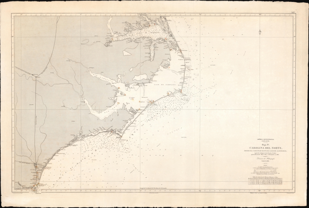
América Septentrional, Costa Este. Hoja IV. Carolina del Norte desde el Cabo Fear hasta el lago de Albemarle.
1868 (dated) 27.5 x 40.75 in (69.85 x 103.505 cm) 1 : 450000
1868 (dated) 27.5 x 40.75 in (69.85 x 103.505 cm) 1 : 450000
Description
A curious nautical map or chart of the North Carolina coast, produced in 1868 by Spain's Dirección de Hidrografía. Surveyed before the U.S. Civil War but published afterwards, the chart reflects both Spain's investment in naval modernization in the preceding decades and a continued interest in the Americas, despite having lost most of its colonial empire earlier in the century.
When the Civil War broke out in 1861, Spain and the Confederacy seemed like natural allies. Like the Confederacy, Spain was the only European country that continued to support slavery, in its Puerto Rican and Cuban plantations. Nonetheless, like other European powers Spain refused to officially sanction the Confederacy, instead signing a declaration of neutrality in 1861. At the same time, enterprising Spanish merchants and ship owners were not discouraged from running the Union naval blockades to supply the south. Spain also became embroiled in the maddeningly complex CSS Stonewall incident, whereby a ship commissioned by the Confederacy was built in France, then passed around Europe by countries who wanted to avoid any overt support for the rebels. The ship eventually ended up in Spain, where it needed repairs, then sailed to Havana, where it only arrived after the war had ended. It was eventually sold to Spain, and then immediately transferred to the U.S. government for an equivalent sum; afterwards, it was sold to the Tokugawa Shogunate of Japan, seeking in its dying days to modernize its navy.
Returning to the present chart, it is possible that unofficial wartime assistance to the Confederacy was expected to open up postwar trading opportunities in the South. In any event, Spain was certainly interested in and, thanks to this chart, more familiar with the waters off the former Confederate states.
A Closer Look
Ranging from the Currituck Sound, near the border between North Carolina and Virginia, south to Cape Fear, this chart takes in almost the entirety of the Atlantic coast of North Carolina, including Cape Hatteras and the Outer Banks. Soundings, currents, shoals, variations, islands, beacons, and lighthouses are noted throughout, as are several other features explained in a legend below the title. On land, cities and towns, railways, roads, rivers, canals, forts, and terrain are indicated. A table at bottom-right explains conversion between meters, brazas, and feet.Spain and the Confederacy
This chart is based on surveys undertaken before the U.S. Civil War and was published in the immediate aftermath of the war. After having lost most of its American empire in the early 19th century, Spain entered a period of relative political stability and sustained economic growth leading to a strengthening of its naval and military forces. Indeed, under Leopoldo O'Donnell, Spain's navy grew so fast that by 1860, it was the 4th largest naval power in the world. Spain was well positioned to reassert its colonial power, especially with the United States distracted by the Civil War.When the Civil War broke out in 1861, Spain and the Confederacy seemed like natural allies. Like the Confederacy, Spain was the only European country that continued to support slavery, in its Puerto Rican and Cuban plantations. Nonetheless, like other European powers Spain refused to officially sanction the Confederacy, instead signing a declaration of neutrality in 1861. At the same time, enterprising Spanish merchants and ship owners were not discouraged from running the Union naval blockades to supply the south. Spain also became embroiled in the maddeningly complex CSS Stonewall incident, whereby a ship commissioned by the Confederacy was built in France, then passed around Europe by countries who wanted to avoid any overt support for the rebels. The ship eventually ended up in Spain, where it needed repairs, then sailed to Havana, where it only arrived after the war had ended. It was eventually sold to Spain, and then immediately transferred to the U.S. government for an equivalent sum; afterwards, it was sold to the Tokugawa Shogunate of Japan, seeking in its dying days to modernize its navy.
Returning to the present chart, it is possible that unofficial wartime assistance to the Confederacy was expected to open up postwar trading opportunities in the South. In any event, Spain was certainly interested in and, thanks to this chart, more familiar with the waters off the former Confederate states.
Publication History and Census
This chart was produced by the Dirección de Hidrografía in 1868, based on American surveys between 1854 and 1857, with later corrections and additions. This is the fourth sheet in a series of four, indicating that the Dirección de Hidrografía used the U.S. Coast Survey series 'Atlantic Coast of the United States, in four sheets' as a basis. José de Lorenzo designed the map (in this case, likely meaning translated), E. Perez y Perez engraved it, and Pierre Bacot undertook letter engraving. This chart is listed in the OCLC with an identifier, but no institution is noted as holding it; a search of major Spanish research institutions' catalogs reveals an example held by the Instituto Geográfico Nacional.CartographerS
The Direccion Hidrografía (1787 - 1927), also known as the Deposito Hydrografico and the Direction de Hidrografía, was the Spanish equivalent of the British Admiralty or the U.S. Coast Survey. This organization, founded in 1787, was commissioned to collect and produce accurate nautical charts of all waters frequented by Spanish vessels. In essence, it replaced the Casa de la Contratación de las Indias (House of Trade of the Indies), which closed its doors in 1790. Like most such organizations, the Direccion Hidrografía marked a new age in cartography. Rather than simply collect charts created by navigators, explorers, and merchants, the Direccion Hidrografía worked closely with naval and military personnel to mount cartographic and hydrographic expeditions in pursuit of the most accurate hydrographical, astronomical, and geodetic measurements. The Direccion Hidrografía created a massive library of nautical charts that, though not nearly as common as similar nautical charts by the U.S. Coast Survey and British Admiralty, are highly desirable for the beauty of their manufacture as well as their accuracy and detail. The office was originally located on Calle Ballesta, but relocated to 36 Alcala, both in Madrid. After 1908 the Dirección was subsumed into other governmental agencies. In 1927 the Direccion was absorbed into the Institute and Observatory of San Fernando, located in Cadiz. The library of original maps, charts, and journals was transferred to the Naval Museum of Madrid - where it resides to this day. More by this mapmaker...
Pierre Adolphe Bacot (fl. c. 1851 - 1888), also as Pedro Bacot, was a French-born letter engraver active with the Spanish Dirección General de Hidrografía. He relocated to Madrid in 1848 and operated a workshop on the Calle de la Esperanza. In addition to nautical charts, he engraved letters for the maps in Francisco Coello's important Atlas de España y sus posesiones de Ultramar. Learn More...
Perez, E. Perez y (fl. c. 1864 - 1908) was an engraver with the Spanish Dirección General de Hidrografía most active in the second half of the 19th century. Despite contributing to more than 150 maps, nothing is known of his life, not even his given name. Learn More...
José de Lorenzo (fl. c. 1864 - 1873) was a Spanish geographer and cartographer of the second half of the 19th century. Nothing is known of his life aside from his work with the Dirección General de Hidrografía. Aside from nautical charts, he was a co-author of the important Diccionario marítimo español, which extended to over 5,000 entries as well as a glossary of nautical terms translated between Spanish and French, English, and Italian. Learn More...
The Office of the Coast Survey (1807 - present) founded in 1807 by President Thomas Jefferson and Secretary of Commerce Albert Gallatin, is the oldest scientific organization in the U.S. Federal Government. Jefferson created the "Survey of the Coast," as it was then called, in response to a need for accurate navigational charts of the new nation's coasts and harbors. The spirit of the Coast Survey was defined by its first two superintendents. The first superintendent of the Coast Survey was Swiss immigrant and West Point mathematics professor Ferdinand Hassler. Under the direction of Hassler, from 1816 to 1843, the ideological and scientific foundations for the Coast Survey were established. These included using the most advanced techniques and most sophisticated equipment as well as an unstinting attention to detail. Hassler devised a labor intensive triangulation system whereby the entire coast was divided into a series of enormous triangles. These were in turn subdivided into smaller triangulation units that were then individually surveyed. Employing this exacting technique on such a massive scale had never before been attempted. Consequently, Hassler and the Coast Survey under him developed a reputation for uncompromising dedication to the principles of accuracy and excellence. Unfortunately, despite being a masterful surveyor, Hassler was abrasive and politically unpopular, twice losing congressional funding for the Coast Survey. Nonetheless, Hassler led the Coast Survey until his death in 1843, at which time Alexander Dallas Bache, a great-grandson of Benjamin Franklin, took the helm. Bache was fully dedicated to the principles established by Hassler, but proved more politically astute and successfully lobbied Congress to liberally fund the endeavor. Under the leadership of A. D. Bache, the Coast Survey completed its most important work. Moreover, during his long tenure with the Coast Survey, from 1843 to 1865, Bache was a steadfast advocate of American science and navigation and in fact founded the American Academy of Sciences. Bache was succeeded by Benjamin Pierce who ran the Survey from 1867 to 1874. Pierce was in turn succeeded by Carlile Pollock Patterson who was Superintendent from 1874 to 1881. In 1878, under Patterson's superintendence, the U.S. Coast Survey was reorganized as the U.S. Coast and Geodetic Survey (C & GS) to accommodate topographic as well as nautical surveys. Today the Coast Survey is part of the National Oceanic and Atmospheric Administration or NOAA as the National Geodetic Survey. Learn More...
Condition
Very good. Slight toning. Original deckled edges.
References
OCLC 803476081. Instituto Geográfico Nacional, S1-35-A-39.