This item has been sold, but you can get on the Waitlist to be notified if another example becomes available, or purchase a digital scan.
1943 Owens and Minneapolis Morning Tribune Map of the Northeast Passage
NortheastPassage-owens-1943$175.00

Title
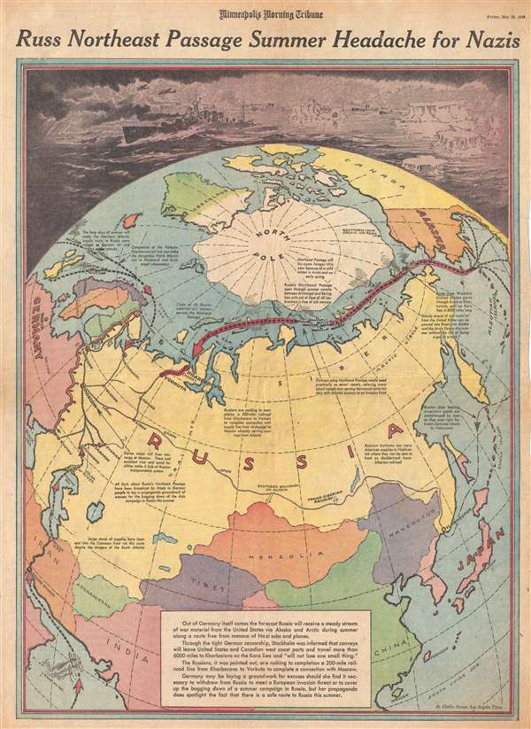
Russ Northeast Passage Summer Headache for Nazis.
1943 (dated) 21.75 x 15.5 in (55.245 x 39.37 cm)
1943 (dated) 21.75 x 15.5 in (55.245 x 39.37 cm)
Description
This is a Friday, May 28, 1943 Charles Hamilton Owens and Minneapolis Morning Tribune pictorial map of Asia illustrating the Northeast Passage. The map depicts the Earth from a polar perspective, with the North Pole at the center, Europe and Asia situated below the North Pole, and Alaska, Canada, and Greenland to the right and above the Pole. This highly important, and rarely discussed, trade route between the western United States and Kharbarovo in Russia, gets overshadowed by the carnage of the Atlantic shipping routes. Some text, situated throughout the map, explains the situation in this theater and what different shipping routes were available from the United States to its Allies.
By bringing attention to the relative success achieved by sending supplies to the Russians through the Northeast Passage, Owens and the newspapers that published this map brought hope to the American people that the sacrifices they were making to support the war effort were not completely in vain. Per the map, a 'steady stream of war material from the United States can be poured into Russia via Alaska and the Arctic Ocean this summer without risk of losing a gun or a tank.' Hundreds of thousands of tons of shipping were being lost in the Atlantic every month to German U-Boats, surface ships, and aircraft, thus the idea that shipments could be sent to the Russians with certainty that they would arrive was incredible. In May 1943, the Russians were the only Allied power in combat in continental Europe. The United States, Britain, and Free France were fighting Germany in North Africa, but the Allies wouldn't invade Italy until September 1943, and the Allied invasion of France would not take place until June 1944. Thus, any material support that could be provided to the Russians would directly go toward fighting an enemy that America couldn't engage any other way.
When Charles Hamilton Owens drew this map he was doubtless inspired by the work of Richard Edes Harrison, an American illustrator and cartographer who, working for Fortune magazine, pioneered a new style of representing the world for WWII era propaganda maps. Edes developed the convention of using spherical perspective with an exaggerated vertical dimension, as on the present map, to illustrate part of the world as part of a greater global situation. This map was created by Charles Hamilton Owens and printed in the Minneapolis Morning Tribune on Friday, May 28, 1943.
CartographerS
Charles Hamilton Owens (Feb 16, 1881 - March 3, 1958) was an American painter and illustrator and staff illustrator for the Los Angeles Times. Born in San Francisco, he had a passion for drawing from a young age. After landing a job as a messenger for The San Francisco Examiner, Owens began being taught his trade by the newspaper's illustrators. Although it is unclear exactly where Owens started his career as a newspaper staff artist, his reputation was launched by his detailed sketches of the 1906 San Francisco earthquake and fire for a New York paper, using only wire reports and his knowledge of the city. By 1910, Owens was working for the Los Angeles Examiner. Even at this point in his career, Owens was known for experimenting with new forms of illustration, fusing drawings of events with photographs. Owens's map of the Titanic disaster used a high oblique perspective, 'capturing the earth's sphericity and showing the polar regions on a curving horizon.' By the 1920s, Owens reputation as an artist in Los Angeles had grown beyond the realm of journalism. He had a studio and received commissions for landscapes and had exhibited watercolors of California and Hawaii landscapes. Thus, when Owens began creating his war series in April/May 1942, he had all the necessary skills to create visually striking works. The Los Angeles Times began a series of maps for its readers, which were full-page inserts that would appear every Monday and Saturday. Owens's maps would be included in the Monday issues, and a Rand McNally map would be included on Saturdays. The Rand McNally maps, however, were discontinued on June 27, 1942, but Owens's maps continued to be printed. His last war map was published on September 10, 1945, a little over a week after the Japanese surrender. Owens died in Los Angeles on March 3, 1958. More by this mapmaker...
The Minneapolis Tribune (1867 - present) was founded by Colonel William S. King, William D. Washburn, and Dorilus Morrison and the first issue was published on May 25, 1867. In 1941, the Cowles family of Des Moines, Iowa bought the Tribune and merged it with their other holdings in Minneapolis, giving the Cowles family ownership of all the city's major newspapers. The Tribune became the city's morning newspaper, and the Star-Journal was the evening newspaper. The two published a joint Sunday edition. The newspaper is still published today, under the name Star Tribune. Learn More...
Condition
Very good. Newsprint. Even overall toning. Closed tears along margins professionally repaired on verso. Text on verso.