This item has been sold, but you can get on the Waitlist to be notified if another example becomes available, or purchase a digital scan.
1814 Thomson Map of the Northern Hemisphere and the Arctic
NorthernHemisphere2-thomson-1814$50.00

Title
Northern Hemisphere.
1814 (dated) 22 x 21 in (55.88 x 53.34 cm) 1 : 41000000
1814 (dated) 22 x 21 in (55.88 x 53.34 cm) 1 : 41000000
Description
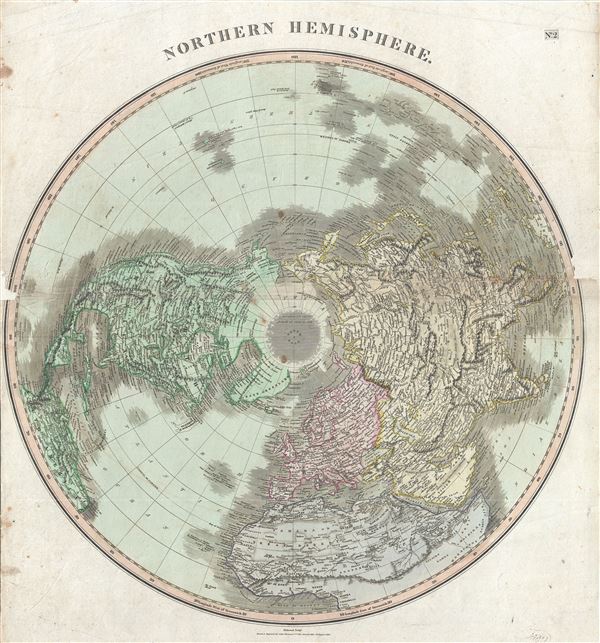
This fascinating hand colored 1814 map by Edinburgh cartographer John Thomson depicts the Northern Hemisphere from the Arctic to the Equator. Includes all of North America, Europe, and Asia as well as the northern part of Africa and South America. Impressive detail encompasses both political and geographic features. In Africa the mythical Mountains of Kong are shown extending eastward to join with the Mountains of the Moon – mythical source of the Nile River. Exhibits a general lack of information regarding the Arctic and connects Greenland with the mainland. Seems to leave the possibility of a Northeast though not a Northwest Passage open. Engraved by Kirkwood and published by Baldwin and Cradock as plate no. 2 in Thomson's New General Atlas.
CartographerS
John Thomson (1777 - c. 1841) was a Scottish cartographer, publisher, and bookbinder active in Edinburgh during the early part of the 19th century. Thomson apprenticed under Edinburgh bookbinder Robert Alison. After his apprenticeship, he briefly went into business with Abraham Thomson. Later, the two parted ways, John Thomson segueing into maps and Abraham Thomson taking over the bookbinding portion of the business. Thomson is generally one of the leading publishers in the Edinburgh school of cartography, which flourished from roughly 1800 to 1830. Thomson and his contemporaries (Pinkerton and Cary) redefined European cartography by abandoning typical 18th-century decorative elements such as elaborate title cartouches and fantastic beasts in favor of detail and accuracy. Thomson's principle works include Thomson's New General Atlas, published from 1814 to 1821, the New Classical and Historical Atlas of 1829, and his 1830 Atlas of Scotland. The Atlas of Scotland, a work of groundbreaking detail and dedication, would eventually bankrupt the Thomson firm in 1830, at which time their plates were sequestered by the court. The firm partially recovered in the subsequent year, allowing Thomson to reclaim his printing plates in 1831, but filed again for bankruptcy in 1835, at which time most of his printing plates were sold to A. K. Johnston and Company. There is some suggestion that he continued to work as a bookbinder until 1841. Today, Thomson maps are becoming increasingly rare as they are highly admired for their impressive size, vivid hand coloration, and superb detail. More by this mapmaker...
Baldwin and Cradock (fl. c. 1810 - 1860) were London based publishers working in the early to mid 19th century. They are best known for their publication of the Society for the Diffusion of Useful Knowledge's ground breaking subscription atlas. They also published John Thomson's magnificent New General Atlas from 1814 - c. 1820. In addition to their cartographic corpus, the firm had wide ranging publishing interests in many other areas, including books, broadsides, and an investment in Blackwoods Magazine. They had their offices at 47 Paternoster Row, London, England. This firm also published under the imprint Baldwin, Cradock, and Joy and Cradock and Joy. Learn More...
Source
Thomson, John. A new general atlas, consisting of a series of geographical designs, on various projections, exhibiting the form and component parts of the globe; and a collection of maps and charts, delineating the natural and political divisions of the empires, kingdoms, and states in the World. Constructed from the best systematic works, and the most authentic voyages and travels. With a memoir of the progress of geography, a summary of physical geography, and a consulting index to facilitate the finding out of places. (1817 edition).
Condition
Good. Overall toning and foxing at places. Some wear and damage near original centerfold and loss near left and right borders, with verso repair and extension. Priced accordingly. Professionally flattened and backed with archival tissue for stability.
References
Rumsey 1007.003. Phillips (Atlases) 731. Newberry Library: Ayer +135 T4 1817.