
This item below is out of stock, but another example (left) is available. To view the available item, click "Details."
Details
1900 Otis Map of Northern Luzon, the Philippines - Philippine-American War
$950.00
1900 Otis Map of Northern Luzon, the Philippines - Philippine-American War
NorthernLuzon-otis-1900$975.00

Title
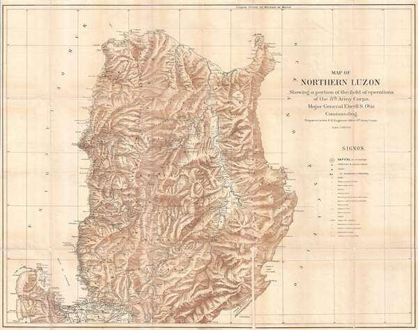
Map of Northern Luzon Showing a portion of the field operations of the 8th Army Corps, Major General Elwell S. Otis Commanding.
1900 (undated) 33 x 43 in (83.82 x 109.22 cm) 1 : 400000
1900 (undated) 33 x 43 in (83.82 x 109.22 cm) 1 : 400000
Description
This is an extremely rare map of Northern Luzon, the Philippines, issued at the height of the Philippine-American War (1899 – 1902) by the Military Governor in the Philippines, Major General Elwell Stephen Otis and the 8th Army Engineering Corps. Drawn on a scale of 1 : 400000, this map is one the largest and most detailed cartographic productions to emerge from the Philippine-American War. It depicts the northern part of Luzon from the Gulf of Lingayen and Pangasinan north to Cabo Engaño and Pta. Mayraira, an area largely controlled by Philippine forces during the early stages of the war. The map offers detailed topography via shading throughout, identifying roadways, towns and cities, political boundaries, telegraph lines, and more. The map appears to have been based upon Spanish sources, as some of the place names and the map key is in Spanish.
This map was prepared by the 8th Army Engineering Corps on the order of Major General E. S. Otis. It was printed by A. B. Graham Photo Lithography of Washington D. C. It appears to be quite scarce, with only two examples identified in the OCLC and no known market history.
This map was prepared by the 8th Army Engineering Corps on the order of Major General E. S. Otis. It was printed by A. B. Graham Photo Lithography of Washington D. C. It appears to be quite scarce, with only two examples identified in the OCLC and no known market history.
CartographerS
Andrew B. Graham (1845 - September 9, 1909) was an American lithographer active in Washington, D.C. in late 19th and early 20th century. Graham was born in Washington D.C., the son of a lithographer and engraver. After college, he joined the U.S. Coast Survey, where he was a draftsman until 1889. He retired from the Coast Survey to take over management of his father's lithography firm. The firm, Andrew B. Graham Company, was one of several that thrived on lucrative government publication contracts. Graham died of 'brain fever' in his Washington D. C. residence on September 9 of 1909. Some of his work was republished posthumously until about 1917, and his firm was active until at least the early 1920s. More by this mapmaker...
Elwell Stephen Otis (March 25, 1838 - October 21, 1909) was a United States army officer who served in the American Civil War, Indian Wars, the Philippines late in the Spanish-American War and during the Philippine-American War, where he commanded the Eighth Corps. He served following the Philippine-American War as the Military Governor General of the Philippines. While not popular in the Philippines due to his authoritarian and 'pompous' manner, he was a skilled and capable administrator. Otis was replaced in the Philippines by the more popular Douglas MacArthur in 1900. Otis died in Rochester, New York on October 21, 1909 from painful angina. Learn More...
Condition
Good. Professionally flattened and laid on archival tissue. Some repaired loss, wear, and soiling along original fold lines. Even overall toning.
References
OCLC 380833003.