This item has been sold, but you can get on the Waitlist to be notified if another example becomes available, or purchase a digital scan.
1795 Carey / Scott Map of the North Pacific; Routes of Exploration
NorthPacific-carey-1795$225.00

Title
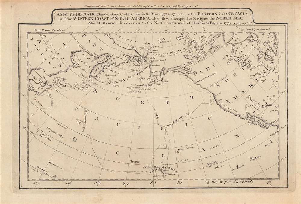
A map of the discoveries made by Capts. Cook and Clerke in the years 1778 and 1779...
1795 (undated) 8.5 x 12.5 in (21.59 x 31.75 cm) 1 : 41000000
1795 (undated) 8.5 x 12.5 in (21.59 x 31.75 cm) 1 : 41000000
Description
This is a rare c. 1795 map of the northern Pacific Ocean from Carey's General Atlas, the first atlas published in the new American Republic. It highlights the three Pacific voyages of Captain James Cook and the overland route from Hudson's Bay to the Artic Ocean, 'discovered,' with critical help from indigenous guides, by Samuel Hearne.
After Cook's death, the expedition was led by Charles Clerke, an officer who had served with Cook on the previous Pacific voyages. However, Clerke was suffering from advanced tuberculosis and was bedridden until his death off the Pacific coast of Siberia on August 22, some six months after Cook. Command then passed to John Gore, who eventually led the expedition back to London in October 1780, with the crew decimated and demoralized. Nevertheless, the voyage collected important cultural, scientific, and geographic information and helped solidify Cook's reputation as one of the great explorers of his age.
Hearne was totally reliant upon Indian guides, both groups with established connections with the British (namely the Cree and Chipewyan) and First Nations who had only intermittently traded with the British. More specifically, Hearne was accompanied by a group of 'Yellowknife' (Dene) hunters and a hunter-guide named Matonabbee (c. 1737–1782), who was in effect the leader of the expedition. It would not be an exaggeration to say that Matonabbee deserves the credit for discovering the route, as well as keeping Hearne alive through several harrowing difficulties during the expeditions.
In addition to reaching the Arctic, Hearne's expedition showed that there was no Northwest Passage below the Arctic. These discoveries were marred by the massacre of twenty Inuit ('Copper Inuits'), with whom the Dene were at war, soon before the expedition reached the Arctic. After the expedition's success, a smallpox epidemic and the French capture of the British Hudson Bay trading posts destroyed Matonabbee's business as a middleman for the British and he committed suicide in 1782.
A Closer Look
The scope of this conic projection map stretches from the Russian Far East and Japan to the west coast of North America and through the continent to Hudson's Bay. Elements of this geography were only loosely understood at the time, as reflected in the odd proportions of Alaska, Sakhalin (Sagaleen), and Ezo (Jeiso), as well as the inclusion of the Pescadores (Penghu) but not the much larger Taiwan (Formosa) nearby. Two prime meridians of Greenwich and Philadelphia are given, the latter being standard in Carey's Atlas.Captain Cook and Charles Clerke
Captain James Cook made three pioneering Pacific voyages between 1768 and 1779, being the first European to traverse and map much of the Pacific. By the time of his third long-distance voyage in 1776, Cook was a very experienced naval officer and a celebrated figure in elite and scientific circles. On his third voyage, after briefly stopping at the Hawaiian Islands in January 1778, Cook explored the west coast of North America up to the Bering Strait before returning to Hawaii in early 1779. After possibly being mistaken for a deity, Cook and his crew got into scuffles with the local population and attempted to kidnap Kalaniʻōpuʻu, the King of Hawaii. In the ensuing fracas, Cook was attacked and killed, but was still somewhat revered by the local people and his remains were given ceremonial treatment.After Cook's death, the expedition was led by Charles Clerke, an officer who had served with Cook on the previous Pacific voyages. However, Clerke was suffering from advanced tuberculosis and was bedridden until his death off the Pacific coast of Siberia on August 22, some six months after Cook. Command then passed to John Gore, who eventually led the expedition back to London in October 1780, with the crew decimated and demoralized. Nevertheless, the voyage collected important cultural, scientific, and geographic information and helped solidify Cook's reputation as one of the great explorers of his age.
Samuel Hearne and Matonabbee
Samuel Harne (February 1745 – November 1792) undertook three expeditions from Hudson's Bay from late 1769 – 1772, the last of which reached the Artic Ocean, making him the first European to arrive at the Article via an overland route. Hearne's original mission was to locate copper which might be mined, as the British were aware that northern First Nations peoples had copper goods (thus their being labelled 'Copper Indians' here).Hearne was totally reliant upon Indian guides, both groups with established connections with the British (namely the Cree and Chipewyan) and First Nations who had only intermittently traded with the British. More specifically, Hearne was accompanied by a group of 'Yellowknife' (Dene) hunters and a hunter-guide named Matonabbee (c. 1737–1782), who was in effect the leader of the expedition. It would not be an exaggeration to say that Matonabbee deserves the credit for discovering the route, as well as keeping Hearne alive through several harrowing difficulties during the expeditions.
In addition to reaching the Arctic, Hearne's expedition showed that there was no Northwest Passage below the Arctic. These discoveries were marred by the massacre of twenty Inuit ('Copper Inuits'), with whom the Dene were at war, soon before the expedition reached the Arctic. After the expedition's success, a smallpox epidemic and the French capture of the British Hudson Bay trading posts destroyed Matonabbee's business as a middleman for the British and he committed suicide in 1782.
Publication History and Census
This map is likely from an early edition of Carey's General Atlas (sometimes subtitled American Edition of Guthrie's Geography improved), multiple editions of which were printed between 1795 and 1818. This is likely an early edition as later editions included colored ink to show borders between countries or to shade entire countries to more easily distinguish them. It appears to be identical to the edition included in the David Rumsey Map Collection, which is dated to 1795. The prevalence of the map is difficult to determine since the map is not always cataloged with the year recorded, but both the individual map and the entire atlas are held by a small handful of universities and research institutions in the United States and Europe.CartographerS
Matthew Carey (January 28, 1760 - September 16, 1839) was a Dublin born publisher who established himself in Philadelphia in the late 18th and early 19th century. A young man of socially progressive views, Carey's first known publication, produced when he was but 17 years old, was a pamphlet criticizing dueling. Another pamphlet, issued in the same year, attacked the Irish penal code. Shortly afterwards, in 1779, legal issues, possibly arising from his liberal political activism, forced Carey to flee to Paris. In Paris, Carey had the good fortune to befriend the visiting American diplomat and founding father, Benjamin Franklin (1706 - 1790). As an Irishman chafing under the rule of England, Carey sympathized with and admired the American revolutionary. The liberally minded pair struck up a lifelong friendship and Carey was hired to work at Franklin's press in Passy, France. A year later, Carey returned to Ireland and resumed his politically provocative publishing career with The Freemans's Journal and The Volunteer's Journal. It didn't take long for political pressure to once again force Carey from Ireland - this time to America (1784). Although largely without funds, Carey convinced Gilbert du Motier, Marquis de Lafayette (1757 - 1834), who he knew from Franklin's Paris circle, to lend him funds to establish a new publishing concern in Philadelphia. Despite this loan, Carey's firm remained under financed and opened on a shoestring budget. It was most likely his limited budget that led Carey to some of his most important publishing innovations. At the time cartographic publishing was dominated by large printing houses in London and Paris where most, if not all, of the work was completed in house. Without the finances to emulate this large publishing houses, Carey was forced to outsource much of his publishing work. This set the stage for subsequent American publishers who, in order to compete effectively with European firms, relied on an often bewildering network of alliances and collaborations. Carey was also a master of republishing many of his own maps in multiple different atlases and formats to maximize their profitability. His most important work is without a doubt the 1795 issue of the American Atlas the first atlas to be published in America. Carey died in 1839 but was succeeded by his son Henry Charles Carey (1793 - 1879) who, in partnership with his brother-in-law Isaac Lea (1792 - 1886), published numerous important maps and atlases under the Carey and Lea, Lea Brothers, and Lea and Blanchard imprints. More by this mapmaker...
Joseph T. Scott (fl. c. 1794 - 1811) was a Philadelphia-based publisher and engraver. Scott engraved many of the maps for Mathew Carey's Carey's American edition of Guthrie's Geography improved published in 1795. He also engraved maps that appeared in John Gibson's Atlas Minimus published in 1798. Learn More...
William Guthrie (1708 - March 9, 1770) was a Scottish historian, journalist, and writer. Born in Brechin, he studied at Aberdeen University with the idea of becoming a parochial schoolmaster. Instead, in 1730, he elected to settle in London and try his hand at literature. He covered parliamentary debates f or the Gentleman's Magazine and soon earned a reputation for being a political writer. He published several scholarly works, including a History of England from the Invasion of Julius Caesar to 1688 in four volumes, and, most notably, his Geographical Historical, and Commercial Grammar. Learn More...
Condition
Very good.
References
Rumsey 2542.020. OCLC 1122782581, 1082523046.