This item has been sold, but you can get on the Waitlist to be notified if another example becomes available, or purchase a digital scan.
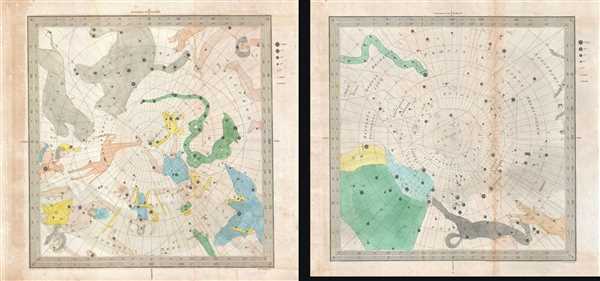
1845 Bradford Set of Two Celestial Maps of the Constellations at the Poles
NorthSouthCelestial-bradford-1845$175.00

Title
Circumjacent the North Pole. / Circumjacent the South Pole.
1845 (undated) 12 x 12 in (30.48 x 30.48 cm)
1845 (undated) 12 x 12 in (30.48 x 30.48 cm)
Description
This is a set of two (2) 1845 Duncan Bradford celestial maps of the constellations as seen from the Northern and Southern Hemispheres, respectively. The Pole is situated at the center of each map, with lines of latitude illustrated in expanding concentric circles emanating outward from the center. Each hemisphere is illustrated from the Pole to forty degrees latitude, meaning that neither hemisphere is illustrated in full. The constellations within view in each hemisphere are beautifully colored and stars throughout each hemisphere are illustrated. Each star is illustrated in such a way that both their name and magnitude are rendered, which allows even more information to be included on the map. A key explaining the differences in notations used to identify stars is situated along the right side of both maps, along with the notations for nebulae and variable stars. In the Northern Hemisphere, both Ursa Major and Ursa Minor are illustrated, as are the Lynx, Auriga, Perseus, Camelopardus, Cassiopeia (Cassippea), Cepheus, and Cygnus, along with a few others. In the Southern Hemisphere, Centauris, Lupus, Sagittarius, and Eridanus are depicted in part or in full, and numerous star clusters are also indicated.
These two celestial maps were engraved by George Washington Boynton and published by Duncan Bradford in his book The Wonders of the Heavens… in 1845.
These two celestial maps were engraved by George Washington Boynton and published by Duncan Bradford in his book The Wonders of the Heavens… in 1845.
Cartographer
George Washington Boynton (fl. c. 1830 - 1850) was a Boston based cartographer and map engraver active in the first half of the 19th century. Boynton engraved and compiled maps for numerous publishers including Thomas Bradford, Nathaniel Dearborn, Daniel Adams, and S. G. Goodrich. His most significant work is most likely his engraving of various maps for Bradford's Illustrated Atlas, Geographical, Statistical, and Historical, of the United States and the Adjacent Countries and Universal Illustrated Atlas. He also engraved for the Boston Almanac. In 1835, Boynton is listed as an employee of the Boston Bewick Company, an engraving, stereotype, and printing concern based at no. 47 Court Street, Boston. Little else is known of his life. More by this mapmaker...
Source
Bradford, D. The Wonders of the Heavens, Being a Popular View of Astronomy, Including a Full Illustration of the Mechanism of the Heavens; Embracing the Sun, Moon, and Stars, with Descriptions of the Planets, Comets, Fixed Stars, Double Stars, the Constellations, the Galaxy, or Milky-Way, the Zodiacal Light, Aurora Borealis, or Northern Lights, Meteros, Clouds, Falling Stars, Aërolyts, etc. (Boston: Otis, Broaders, and Co.) 1845.
Condition
Very good. Light toning. Blank on verso.