1944 U.S. Coast and Geodetic Survey Nautical Chart / Map of Northwestern Palawan, Philippines
NorthwesternPalawan-uscgs-1944$500.00

Title
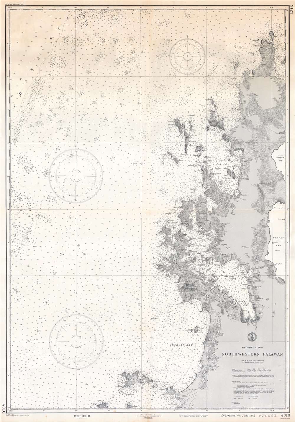
Philippine Islands. Northwestern Palawan.
1944 (dated) 45.75 x 32 in (116.205 x 81.28 cm) 1 : 112500
1944 (dated) 45.75 x 32 in (116.205 x 81.28 cm) 1 : 112500
Description
This is a 1944 U.S. Coast and Geodetic Survey nautical chart or maritime map of the northwestern coast of Palawan, Philippines - prepared for World War II, but today representing a world renowned ecotourism mecca. The present example represents a special printing published in May 1944 in preparation for the Allied invasion of the Philippines. Coverage extends from Cabuli Island south along the coast to Pagdanan Bay, with peninsulas, bays, and points are illustrated and labeled. Inland topography is defined by contouring with elevations in feet. Depth soundings appear along the coast and as far west as the China Sea, providing essential maritime data. Information concerning tides, abbreviations, and other important data is included below the title in the lower right.
The Philippine Campaign
Launched on October 20 of 1944, the Philippine Campaign was a World War II joint American and Filipino military operation intended to liberate the Philippine Islands from occupying Imperial Japanese forces. The Japanese Army overran most of the Philippines during the first half of 1942, retaining it for the subsequent 2 years. American General Douglas MacArthur began the campaign by announcing on Philippine radio 'This is the Voice of Freedom, General MacArthur speaking. People of the Philippines: I have returned.' The campaign progressed rapidly, driving the Japanese out of one island after another. Although by this time the Japanese were clearly losing the war, they gave no sign of capitulation and refused to surrender. During the course of the campaign Japan suffered nearly half a million casualties compared to only about 50,000 Americans. The campaign continued until Japanese forces in the Philippines were ordered to surrender by Tokyo on August 15, 1945, after the dropping of atomic bombs on Hiroshima and Nagasaki.A world-renowned ecotourism destination
Northwestern Palawan is renowned worldwide as an ecotourism destination. Its pristine beaches and crystal-clear waters call more than one million visitors to Palawan annually. El Nido and Coron are must-visit destinations Philippine tourists.A Special Printing - Publication History and Census
This edition of this chart was printed in May 1944, five months before the Allied invasion of the Philippines during World War II. First published in Manila in June 1938, the chart was then reissued in February 1939. The Philippines fell to the Japanese in 1942. The U.S. government issued the first special printing of this chart in May 1942, with the present edition appearing a little under two years later. We note only one example of any edition of this chart cataloged in OCLC, which is part of the collection at Stanford University and represents the reissued February 1939 edition.Cartographer
The Office of the Coast Survey (1807 - present) founded in 1807 by President Thomas Jefferson and Secretary of Commerce Albert Gallatin, is the oldest scientific organization in the U.S. Federal Government. Jefferson created the "Survey of the Coast," as it was then called, in response to a need for accurate navigational charts of the new nation's coasts and harbors. The spirit of the Coast Survey was defined by its first two superintendents. The first superintendent of the Coast Survey was Swiss immigrant and West Point mathematics professor Ferdinand Hassler. Under the direction of Hassler, from 1816 to 1843, the ideological and scientific foundations for the Coast Survey were established. These included using the most advanced techniques and most sophisticated equipment as well as an unstinting attention to detail. Hassler devised a labor intensive triangulation system whereby the entire coast was divided into a series of enormous triangles. These were in turn subdivided into smaller triangulation units that were then individually surveyed. Employing this exacting technique on such a massive scale had never before been attempted. Consequently, Hassler and the Coast Survey under him developed a reputation for uncompromising dedication to the principles of accuracy and excellence. Unfortunately, despite being a masterful surveyor, Hassler was abrasive and politically unpopular, twice losing congressional funding for the Coast Survey. Nonetheless, Hassler led the Coast Survey until his death in 1843, at which time Alexander Dallas Bache, a great-grandson of Benjamin Franklin, took the helm. Bache was fully dedicated to the principles established by Hassler, but proved more politically astute and successfully lobbied Congress to liberally fund the endeavor. Under the leadership of A. D. Bache, the Coast Survey completed its most important work. Moreover, during his long tenure with the Coast Survey, from 1843 to 1865, Bache was a steadfast advocate of American science and navigation and in fact founded the American Academy of Sciences. Bache was succeeded by Benjamin Pierce who ran the Survey from 1867 to 1874. Pierce was in turn succeeded by Carlile Pollock Patterson who was Superintendent from 1874 to 1881. In 1878, under Patterson's superintendence, the U.S. Coast Survey was reorganized as the U.S. Coast and Geodetic Survey (C & GS) to accommodate topographic as well as nautical surveys. Today the Coast Survey is part of the National Oceanic and Atmospheric Administration or NOAA as the National Geodetic Survey. More by this mapmaker...
Condition
Very good. Exhibits wear and toning along original centerfold.
References
OCLC 921298557 (1939).