This item has been sold, but you can get on the Waitlist to be notified if another example becomes available, or purchase a digital scan.
1788 Schraembl Map of the Northwest Passage (Alaska, Pacific Northwest)
NorthwestPassage-schraembl-1788$297.50

Title
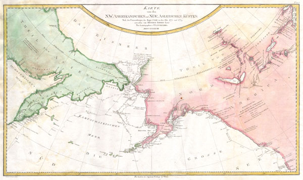
Karte von den N.W. Amerikanischen und N.OE. Asiatischen Kusten nach den Untersuchungen des Kapit. Cook in den Jah. 1778 und 1779
1788 (dated) 15.5 x 27 in (39.37 x 68.58 cm)
1788 (dated) 15.5 x 27 in (39.37 x 68.58 cm)
Description
A rare German language variant of Cook's map of his explorations along the northwest coast of America and the northeast coast of Asia. Based upon original work by Cook's cartographer Henry Roberts. Depicts much of Siberia and Kamtschaka in Asia and, in America, shows Canada as far east as the western portions of Hudson Bay. Alaska and Asia are shown with considerable accuracy though Vancouver Island is missing. Shows several lakes west of Hudson Bay in what is today northwestern Canada. Numerous depth soundings detailed along the exploration tracks. In addition to Cook's work, also notes the explorations of Bodega and the inland discoveries of Hearn, and others. Engraved by I.C. Lackner for the 1788 edition of the Allgemeiner Grosser Atlas, plate no. 107.
Cartographer
Franz Anton Schrämbl (Schraembl; 1751 - December 13, 1803) was a Vienna-based cartographer working in the later part of the 18th century. Schrämbl was born in Vienna. He became director of the normal school in Troppau but soon quit to set up a bookshop in Vienna. In 1787, with fellow Austrian Franz Johann Joseph von Reilly (1766 - 1820), he founded a publishing firm. He began his great work, the Allgemeiner Grosser Atlas, in the same year. This ambitious large format atlas was to be based upon only the most up-to-date cartographic information available, among them cartographers J. B. B. D'Anville (1697 - 1782) and James Rennel (1742 - 1830), and explorers such as James Cook (1728 - 1779), Charles Roberts (1739 - 1825), and others. The atlas was published in 1800 and became the first Austrian commercial world atlas. The work experienced minimal circulation, possibly due to its high cost. The low sales nearly drove Schrämbl into insolvency, but he recovered through diversification into literature and art books. When Franz Anton died in 1803, his widow Johanna and her brother, the engraver Karl Robert Schindelmayer (1769 - 1839), assumed control of the firm. In 1825, his son, Eduard Schrämbl, took over. More by this mapmaker...
Source
Schraembl, K. A., Allgemeiner Grosser Atlas, (Vienna: Phil. Jos. Schalbacher) 1800.
The Allgemeiner Grosser Atlas, alternatively titled Allgemeiner Grosser Schrämblischer Atlass, is considered the first Austrian commercial Atlas. It is a massive elephant folio atlas published in 1800 by Franz Anton Schrämbl (Schraembl; 1751 - 1803). The atlas drew from the best and most up-to-date cartographic information available, including the works of J. B. B. D'Anville (1697 - 1782) and James Rennel (1742 - 1830), and explorers such as James Cook (1728 - 1779), and Charles Roberts (1739 - 1825), among many others. It was published in Vienna by Phillip Joseph Schalbacher. The atlas was large and expensive, and as such, was of minimal commercial success and had a low circulate - leading to its considerable rarity today. It is believed that the atlas's slow sales and high production costs drove Schrämbl into insolvency by the time of his death in 1803.
Condition
Very good condition. Blank on verso. Wide clean margins. Original platemark visible. Original folds.
References
Phillips, Philip Lee, A List of Geographical Atlases in the Library of Congress, 694-50. Kershaw, Kenneth A., Early Printed Maps of Canada, 1149.