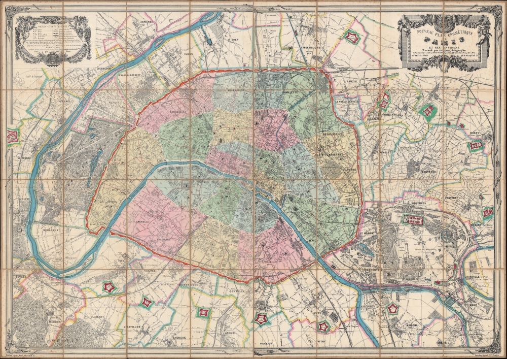
1873 Clérot Folding Wall City Plan or Map of Paris, France
NouveauGeometriqueParis-clerot-1873$3,000.00


Title
Nouveau plan géométrique de Paris et ses environs.
1873 (dated) 39 x 55 in (99.06 x 139.7 cm) 1 : 15000
1873 (dated) 39 x 55 in (99.06 x 139.7 cm) 1 : 15000
Description
This is an impressive 1873 Victor Clérot city plan or map of Paris, measuring nearly 5 feet wide. In 1873, Paris was in the midst of recovery and transformation, still bearing the scars of the Franco-Prussian War and the Commune of 1871. The Third Republic was consolidating its power, establishing a more stable and democratic government, setting the stage for Paris's resurgence as a center of cultural and intellectual activity in Europe. It also illustrates the Theirs Wall and the city's impressive, if short-lived, fortifications.
A Closer Look
Depicting Paris and its immediate suburbs, streets throughout the region are illustrated and labeled. Monuments within Paris appear, including the Opera, Notre Dame, the Louvre, and the Arc de Triomphe. Paris's city walls are highlighted in red, as are the short-lived ring forts. Outside the walls, both the Bois de Boulogne and the Bois de Vincennes appear in detail. Rail lines run into and out of Paris.The Fortification of Paris
Shocked by the seizure of Paris by foreign enemies during the 1814 Battle of Paris, the French King at the time, Louis-Philippe (1830 - 1848), conceived of a broad network of walls and forts he believed would make Paris impregnable. The project was met with immediate opposition, some of which claimed that the walls were not defensive but intended to control Parisians in the event of an anti-monarchal rebellion. Nonetheless, under a plan prepared by Marshal General Jean-de-Dieu Soult (1759 - 1861), construction began in 1841. The completed fortifications, named the Thiers Wall after the French Prime Minister at the time, Adolphe Theirs (1797 - 1877), were, at enormous expense, completed in 1844. The walls were thirty-three kilometers long and consisted of ninety-four bastions, seventeen gates, twenty-three minor road crossings, and eight railroad gates. By 1919, advancements in military technology made the walls obsolete, leading them to be fully deconstructed by 1929 and replaced with the Boulevard Périphérique.Publication History and Census
This map was drawn and published by Victor Clérot, engraved by Alexandre Martin, and printed by the Imprimerie Hermet in 1873. This is the only known surviving example of the present edition. Clérot published additional editions of the present map in 1870 and 1877.Cartographer
Victor Clérot (fl. 1855 - 1890) was a Paris based geographer and publisher active in the latter half of the 19th century. As with most small volume French map publishers of this period there is very little available information regarding Clérot. We know he published several maps of Paris, a world map, some timelines, and a number of guidebooks, but little else. His offices were located at 23 Quai Malaquais in Paris's 6th Arrondissement. More by this mapmaker...
Condition
Very good. Dissected and mounted on original linen. Foxing. Light scuffing to bottom border.