This item has been sold, but you can get on the Waitlist to be notified if another example becomes available, or purchase a digital scan.
1903 Garnier Pictorial Pocket Plan or Map of Paris, France (Eiffel Tower)
NouveauParisMonumental-garnier-1903$200.00

Title
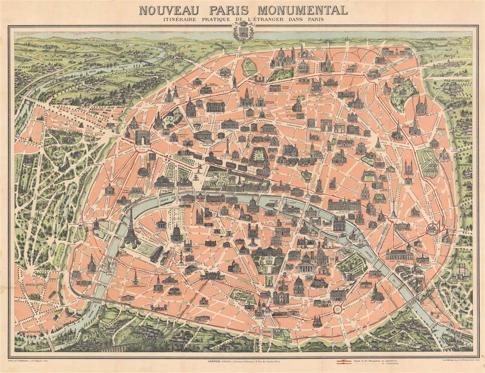
Nouveau Paris Monumental Itinéraire Pratique de l'Étranger dans Paris.
1903 (undated) 21 x 27.5 in (53.34 x 69.85 cm)
1903 (undated) 21 x 27.5 in (53.34 x 69.85 cm)
Description
This is an extremely attractive 1903 Garnier Frères tourist pictorial pocket map of Paris, France. The map depicts the walled city of Paris and the immediate vicinity from Billancourt to Aubervilliers and from Puteau to Charenton. Celebrated tourist sites are shown in profile, including the Eiffel Tower, the Arc de Triomphe, Sacre-Coeur, the Pantheon, and several more. Paris's many train stations are illustrated along with the railroad lines. Both the Bois de Boulogne and the Bois de Vincennes are depicted in stunning detail.
Dating The Map
This map was issued in various editions from, roughly 1900 to 1937. Although most examples are undated, we can assign an approximate date due to the development of the Metro system and the map's overall style and construction. In this case, both Line 1 and Line 2 of the Chemin de fer Métropolitain are open, and today's Line 6 (then known as Line 2 Sud (South)) is under construction. This places the map's publication between January 31, 1903, when Line 2 opened between Étoile and Nation, and November 6, 1903, when Line 2 Sud opened between Passy and the Place d'Italie.Publication History
This map was engraved by L. Poulmaire, printed by Eugène Dufrenoy, and published by Garnier Frères in 1903.CartographerS
Garnier Frères (1833 - June, 1983) was a prominent publishing house and bookstore based in Paris, France. The publishing firm was founded in 1833 by the brothers Auguste (1812 - 1887) and Hippolyte Garnier (1815 or 1816 – 1859, photo at right). Their younger brother Pierre-Auguste (1807 – 1899) also joined the firm. Yet another brother, Baptiste-Louis Garnier (1822 - 1893) joined in 1844. The popular Paris bookshop, located in the arcades of the Palais-Royal in the gallery Peristyle Montpensier, followed shortly after in 1838. They opened another location in 1853 in the former government hotel, at the corner of rue de Lille and rue des Saints-Pères. The firm prospered through the publication of low cost editions French classics. Their corpus of work includes maps, guides, novels, historical works, and essays. In June of 1983 the firm filed for bankruptcy and their assents were taken over by Presses de la Cité, a subsidiary of InfoMédia, which was itself liquidated in 2000. More by this mapmaker...
Eugène Dufrenoy (January 21, 1834 - 190x), aka Dufrenois, was a French printer, lithographer, and engraver active in Paris during the second half of the 19th and the early 20th centuries. Dufrénoy born in Bourg-la-Reine, in what is today the southern suburbs of Paris. He was based, for at least part of his career, at 34 Rue du Four, Paris. In 1881 Dufrénoy acquired a large space at 49 Rue du Montparnasse. This space still operates as a printshop with Dufrénoy's old presses as IDEM Paris. ˜ Learn More...
Condition
Very good. Exhibits light wear along original fold lines. Closed margin tears professionally repaired on verso. Verso repairs to fold separations. Closed tear extending vertically three (3) inches within printed area on right near the Place de la Bastille.