This item has been sold, but you can get on the Waitlist to be notified if another example becomes available, or purchase a digital scan.
1799 Vancouver Map of Australia and New Zealand
NouvelleHollande-vancouver-1799$1,250.00

Title
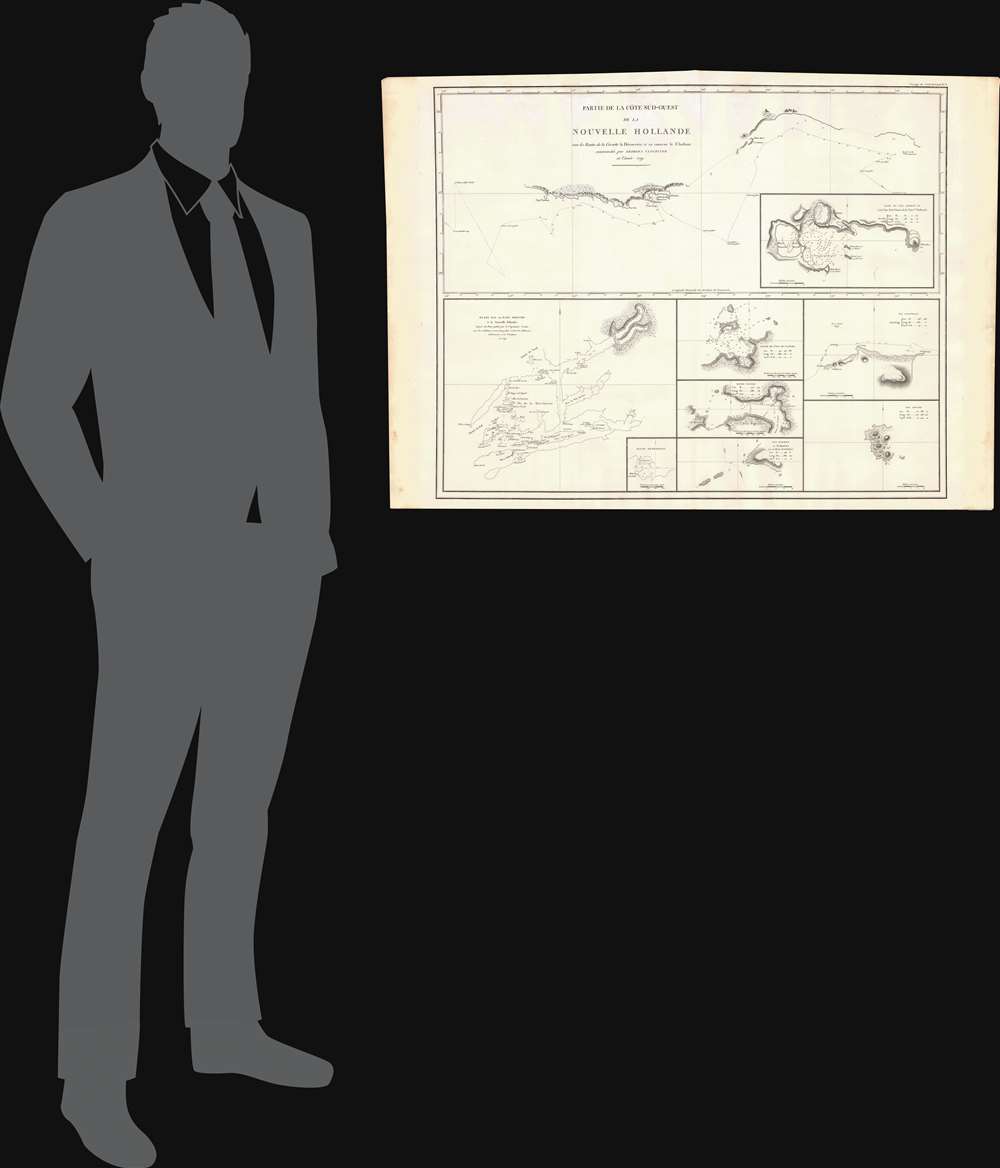
Partie de la Cote Sud-Ouest de la Nouvelle Hollande avec les Routes de la Corvette la Decouverte et sa conserve le Chatham commandes par Georges Vancouver en l'Annee 1791.
1799 (dated 1791) 31 x 25 in (78.74 x 63.5 cm)
1799 (dated 1791) 31 x 25 in (78.74 x 63.5 cm)
Description
One of the great navigator George Vancouver's most important and influential maps, this is Vancouver's 1799 mapping of southwestern Australia and New Zealand. Though less well known than his historic mapping of the Pacific Northwest, Vancouver's work in Australia and New Zealand is no less significant. Vancouver was commissioned to examine 'that extent of coast of the south-west side of New Holland, which in the present age appears a real blot in geography.' In the course of his Australian explorations he discovered and named Oyster Bay, Cape Chatham and Cape Howe, and King George the III Sound, claiming each for Great Britain. Sailing east wind conditions prevented Vancouver from exploring the Australian Bight and led to an abandonment of one of his stated goals – determining whether nor not Van Diemens's land or Tasmania was, as presumed, an island or attached to the mainland. Continuing east Vancouver discovered '7 craggy islands' of the southern tip of New Zealand, which he named the 'Snares.' Chatham Island, named after one of Vancouver's ships,' was also discovered. All of these lands, Vancouver claimed for Great Britain. The cultural and historic importance of Vancouver's work in Australia, then called New Holland, and New Zealand cannot be overestimated. Vancouver's detailed descriptions of the lands he encountered laid the ground work for future settlement of the region by British nationals, giving birth to 'english Australia.'
This particular example of Vancouver's map was issued as plate no. 1 in the highly desirable 1799 French edition of Vancouver's Atlas. The rare and coveted French edition of Vancouver's Atlas is more beautifully produced with better engraving, higher quality paper, and more detail then the 1798 english edition. This scarce map is a core piece for any serious collection focusing on the mapping of Australia and New Zealand.
This particular example of Vancouver's map was issued as plate no. 1 in the highly desirable 1799 French edition of Vancouver's Atlas. The rare and coveted French edition of Vancouver's Atlas is more beautifully produced with better engraving, higher quality paper, and more detail then the 1798 english edition. This scarce map is a core piece for any serious collection focusing on the mapping of Australia and New Zealand.
Cartographer
George Vancouver (June 22, 1750 - May 10, 1798) was a British naval officer and explorer active in the late 18th century. Vancouver was the last of the great naval explores of the 18th century and, along with Captain James Cook and Perouse, is credited with the first accurate mapping of the Northwest Coast of America. Vancouver was born in King's Lynn, England and joined the Royal Navy at age 13 as a seaman. While little is known of Vancouver's early life, he first appears in the annals of history as a midshipmen aboard the HMS Resolution of Captain Cook's second voyage in search of Terra Australis. On this expedition Vancouver claimed to have "been nearer the south pole than any other man" (after climbing the bowsprit before the ship turned back in the face of mountains of Antarctic ice). He also accompanied the third Cook expedition as a midshipman on the HMS Discovery where he witnessed the discovery of the Hawaiian Islands as well as Cooks tragic death on those same islands. Returning to England under Cook's second, Captain Clerke recommended Vancouver for promotion to Lieutenant. Under his new commission he spent several years learning surveying in the Caribbean aboard the HMS Martin, where he also distinguished himself in a number of military altercations with the French. In 1790 Vancouver received an appointment as the Captain of the HMS Discovery and was commissioned to complete the exploration of American's Northwest Coast begun by Cook and Perouse. Between 1791 and 1795 Vancouver's remarkable diligence and attention to detail created the first truly accurate cartographic picture of the American Coast between San Francisco Bay and California. Vancouver was the first to map countless rivers and inlets and to identify Vancouver Island. During his four years of exploration he also spent three winters in Hawaii, creating in the process the first accurate map of the islands. Unlike many earlier explorers Vancouver generally maintained good and respectful relations with the indigenous peoples he encountered. In Hawaii Vancouver allegedly negotiated the cession of Hawaii to England as well as introduced beneficial flora and fauna to the archipelago. Vancouver returned to England in 1795 where he immediately ran afoul of the powers that be. During his voyages Vancouver excited the ire of more than one crew member, including the well-connected naturalist Archibald Menzies, the sailing master Joseph Whidbey, and Thomas Pitt, the powerful Baron of Camelford. Slandered and assaulted by these influential enemies, one of Britian's greatest explorers fell into obscurity. He died shortly after in 1798 and was buried in an unremarkable grave at St. Peter's Churchyard, Petersham, Surrey, England. The journals of Vancouver's expedition, as well as his all-important maps, were published posthumously in the same year as his death. Robin Fisher, the academic Vice President of Mount Royal University in Calgary and author of two books on Vancouver, writes: He [Vancouver] put the northwest coast on the map...He drew up a map of the north-west coast that was accurate to the 'nth degree,' to the point it was still being used into the modern day as a navigational aid. That's unusual for a map from that early a time.
Today Vancouver is memorialized by Vancouver Island, which he discovered, the Hudson Bay Company's Fort Vancouver, the city of Vancouver, Vancouver Peninsula Australia, Mount Vancouver, the 8th highest mountain in Canada, Vancouver Bay in Jervis Inlet, and the Vancouver Maritime Museum. For his 250th birthday, the Canada Post issued a special postage stamp in his honor. More by this mapmaker...
Source
Vancouver, G., Voyage de decouvertes a l'ocean Pacifique du Nord, et autour du monde : dans lequel la cote nord-ouest de l'Amerique a ete soigneusement reconnue et exactement relevee : ordonne par le roi d'Angleterre, principalement dans la vue de constater s'il existe, a travers le continent de l'Amerique, un passage pour les vaisseaux, de l'ocean Pacifique du Nord a l'ocean Atlantique septentrional : et execute en 1790, 1791, 1792, 1793, 1794 et 1795, (Paris : De l'Imprimerie de la Republique) 1799.
Condition
Very good near flawless condition. Original centerfold. Platemark visible. Blank on verso.
References
Rumsey 3354.001 (English edition).