
This item below is out of stock, but another example (left) is available. To view the available item, click "Details."
Details
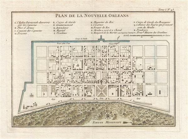
1744 Bellin Map or Plan of New Orleans, Louisiana
1744 (undated) $900.00
1764 Bellin Map of New Orleans, Louisiana
NouvelleOrleans-bellin-1764$500.00

Title
Plan de la Nouvelle Orleans.
1764 (undated) 8 x 11 in (20.32 x 27.94 cm) 1 : 4800
1764 (undated) 8 x 11 in (20.32 x 27.94 cm) 1 : 4800
Description
This scarce 1764 map by J. N. Bellin is one of the earliest obtainable maps of New Orleans, Louisiana. Oriented to the northwest, Bellin's map covers the original settlement of New Orleans along the Mississippi River and inland as far the Fosse plein d'eau (roughly translated: 'Pit full of Water') near modern day Dauphine Street, and from modern day Iberville Street (shown but not named) to modern day Barracks Street (shown but not named). The map shows some 100 buildings with some 18 specifically identified via an alphabetically coded table set just above the map.
Among the locations noted in the key is one that provides an eerie echo of the slave trade. Item Q is identified as Cabanes des Negroes qui prennent soin Moulin or 'Cabins of Negros that care for mill.' Note how these cabins, as well as the adjacent mill, are both well outside the ordered structure of the city as well as conveniently located near the Corps de Garde des Bourgeois.
There are several editions of this map. The present example, while not the earliest, is perhaps the most beautiful due to the addition of finely engraved turbulent waves to represent the water. Bellin originally issued this map in 1744 to illustrate Pierre François Xavier de Charlevoix's Histoire et description generale de la Nouvelle France. Later editions, most with slight modifications, were issued to accompany Provost's Histoire des Voyages, reissues of Charlevoix, and in this case Bellin's 1764 Petit Atlas Maritime.
Cartographer
Jacques-Nicolas Bellin (1703 - March 21, 1772) was one of the most important cartographers of the 18th century. With a career spanning some 50 years, Bellin is best understood as geographe de cabinet and transitional mapmaker spanning the gap between 18th and early-19th century cartographic styles. His long career as Hydrographer and Ingénieur Hydrographe at the French Dépôt des cartes et plans de la Marine resulted in hundreds of high quality nautical charts of practically everywhere in the world. A true child of the Enlightenment Era, Bellin's work focuses on function and accuracy tending in the process to be less decorative than the earlier 17th and 18th century cartographic work. Unlike many of his contemporaries, Bellin was always careful to cite his references and his scholarly corpus consists of over 1400 articles on geography prepared for Diderot's Encyclopedie. Bellin, despite his extraordinary success, may not have enjoyed his work, which is described as "long, unpleasant, and hard." In addition to numerous maps and charts published during his lifetime, many of Bellin's maps were updated (or not) and published posthumously. He was succeeded as Ingénieur Hydrographe by his student, also a prolific and influential cartographer, Rigobert Bonne. More by this mapmaker...
Source
Bellin, J. N., Petite Atlas Maritime, Vol. 1, (Paris) 1764.
Condition
Very good. Wide margins. Thick stock. Original centerfold exhibits minor wear. Blank on verso. Platemark.
References
Lemmon, A., Magill, J., and Wiese, J., Charting Louisiana: Five Hundred Years of Maps, #171. Brown University, John Carter Brown Library, E744 C479h5.