This item has been sold, but you can get on the Waitlist to be notified if another example becomes available, or purchase a digital scan.
1715 De Fer City Map or Plan of Mexico City, Mexico
NouvelleVilleMexique-defer-1715$250.00

Title
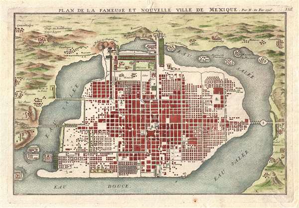
Plan de la Fameuse et Nouvelle Ville de Mexique.
1715 (dated) 9.5 x 13.75 in (24.13 x 34.925 cm) 1 : 42000
1715 (dated) 9.5 x 13.75 in (24.13 x 34.925 cm) 1 : 42000
Description
This is a 1715 Nicolas de Fer city map or plan of Mexico City, Mexico. Although somewhat hard to correlate to the sprawling modern day Mexico City, this map illustrates Mexico shortly after being constructed from the ruins of the razed Aztec capital of Tenochtitlan to be the capital of Spain's Viceroyalty in the New World. The map is oriented with east at the top. The Zocalo and the Cathedral, which was consecrated in 1667, appears at center, and Chapultepec hill is labeled at top center. The grid structure radiating out form the Zocalo is roughly similar to the Centro Historico's modern day grid, though quickly transitions to smaller dwellings and undeveloped land the farther one gets from the Zocalo. Forty-one different locations are numerically identified throughout the city. Individual buildings, both within the city and in the villages surrounding the lake, are illustrated, along with the causeways connecting the island with the 'mainland'. The villages surrounding the lake are also labeled.
Lake Texcoco
The city here is surrounded by a great lake. This is the original Lake Texcoco upon which the ancient Aztec capital of Tenochtitlan was constructed. By building the Spanish colonial capital on the ruins of the center of Aztec political, religious, and commercial life, Cortés cemented his conquest in the minds of the indigenous people. Tenochtitlan, and by extension Mexico City, was founded on an island in the middle of a large inland lake, meaning that the city was essentially surrounded by water. This fact led to serious public health issues during the colonial period, because Cortés destroyed the Aztec drainage system when he built Mexico City. After suffering numerous floods, city officials began to work through the problem and instituted a program of using indigenous labor to build a drainage system. This project, however, was never fully completed under Spanish rule and would never be fully realized. By the nineteenth century, as the population of the city increased, the need for more space became apparent. This new pressure, combined with the constant flooding, led the government to drain the lake surrounding Mexico City. This solution solved both problems by creating more land for people to live on and ending, for the most part, the flooding.
This map is rather uncommon as it was published only in the Suite de l'Atlas Curieux, which was a supplement to De Fer's better known Atlas Curieux. Accompanied by original backmatter.
Cartographer
Nicholas de Fer (1646 - October 25, 1720) was a French cartographer and publisher, the son of cartographer Antoine de Fer. He apprenticed with the Paris engraver Louis Spirinx, producing his first map, of the Canal du Midi, at 23. When his father died in June of 1673 he took over the family engraving business and established himself on Quai de L'Horloge, Paris, as an engraver, cartographer, and map publisher. De Fer was a prolific cartographer with over 600 maps and atlases to his credit. De Fer's work, though replete with geographical errors, earned a large following because of its considerable decorative appeal. In the late 17th century, De Fer's fame culminated in his appointment as Geographe de le Dauphin, a position that offered him unprecedented access to the most up to date cartographic information. This was a partner position to another simultaneously held by the more scientific geographer Guillaume De L'Isle, Premier Geograph de Roi. Despite very different cartographic approaches, De L'Isle and De Fer seem to have stepped carefully around one another and were rarely publicly at odds. Upon his death of old age in 1720, Nicolas was succeeded by two of his sons-in-law, who also happened to be brothers, Guillaume Danet (who had married his daughter Marguerite-Geneviève De Fer), and Jacques-François Bénard (Besnard) Danet (husband of Marie-Anne De Fer), and their heirs, who continued to publish under the De Fer imprint until about 1760. It is of note that part of the De Fer legacy also passed to the engraver Remi Rircher, who married De Fer's third daughter, but Richer had little interest in the business and sold his share to the Danet brothers in 1721. More by this mapmaker...
Condition
Very good. Even overall toning. Small portion of bottom right corner reinstated. Two small sections of bottom margin reinstated. Blank on verso. Accompanied by original French description.
References
OCLC 431570605