
This item below is out of stock, but another example (left) is available. To view the available item, click "Details."
Details
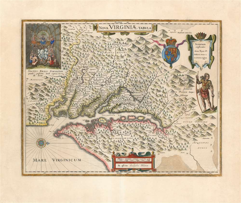
1635 Blaeu Map of Virginia and the Chesapeake (Hondius / Smith)
1635 (undated) $4,000.00
1640 Blaeu Map of Virginia and the Chesapeake (Hondius / Smith)
NovaVirginiaeTabula-blaeu-1640$2,250.00

Title
Nova Virginiae Tabula.
1640 (undated) 15.5 x 19.5 in (39.37 x 49.53 cm) 1 : 1680000
1640 (undated) 15.5 x 19.5 in (39.37 x 49.53 cm) 1 : 1680000
Description
A beautiful, original-color example of Guillaume Blaeu's 1635 map of the Virginia colony and the Chesapeake Bay. Oriented to the west, this map covers from Cape Henry to the Susquehanna River and inland as far as the Appalachian Mountains. The Chesapeake Bay is shown in full as are many of its river estuaries, although topographically this map places a number of mountain ranges where there are in fact none. Cartographically, this map is based upon John Smith's landmark map of the Virginia colony issued in 1612. Smith's fine survey work, as well as reports from indigenous American Indian tribes, and wishful thinking, combine to make this one of the most interesting maps of America to emerge in the 17th century. Philip D. Burden, the author of The Mapping of America, considers this map, Nova Virginiae Tabula, to be
one of the most important maps of America ever produced and certainly one of the greatest influence.
The Sea of Verrazano, or A Proto-Great Lake?
On the upper-right-hand extreme of this map - that is to say, to the northwest - is a stippled, unnamed body of water on whose shores are noted to live the tribe of the 'Massawomecks.' Smith describes this tribe in his The Generall Historie of Virginia, New-England, and the Summer Isles:Beyond the mountains from whence is the head of the River Patawomeke, the Savages report, inhabit their most mortal enemies, the Massawomecks, upon a great salt water, which by all likelihood is either some part of Canada, some great lake, or some inlet of some sea that falleth into the South Sea. These Massawomekes are a great nation and very populous.... from the French (they) have their hatchets and Commodities by trade.Although Smith relates violent encounters with a Massawomeck raiding party on the Chesapeake, the Massawomecks were a fur-trapping and trading tribe nearly as new to the Chesapeake region as Smith - their homeland was actually Lake Erie. Thus, the 'Massawomeck' body of saltwater appearing on this map can be understood as an early, secondhand depiction of Lake Erie. Smith, on the other hand, hoped for an entirely larger body of water: the Pacific, via the legendary Sea of Verrazzano.
Verazzano's Sea
in 1524, Giovanni da Verrazzano had sailed in search of a passage through North America to the Pacific Ocean. While he found nothing he could support with actual exploration, his observations of the barrier islands of the American southeast, the Pamlico Sound, and possibly the Chesapeake Bay, led him to speculate that in places North America was quite narrow, and that in these places only a narrow isthmus separated the Atlantic from the Pacific. Efforts to depict this on maps illustrate a massive body of water plunging into North America from the Pacific nearly to the American mid-Atlantic coastline. This so-called 'Sea of Verrazano' appeared on many 16th century maps and was suggestive of access to the Pacific Ocean from the Atlantic. European mapmakers and explorers - in particular, John Smith and Henry Hudson - hung their hopes on discovering the Verrazano Sea, an assumption would color their interpretations of what they actually discovered. Smith's map reflects his own hope and assumption that that only short marches separated the Jamestown colony from large navigable bodies of water to the west and north. Smith reported as much in a 1609 letter to Henry Hudson; Hudson would act on this intelligence, sailing for the 40°parallel and discovering the river that now bears his name. In the minds of most Europeans of the period, the trade potential for the Virginia colony was entirely dependent upon it being a practical access point to the riches of Asia. Thus, the significance of large and mysterious body of water appearing in the land of the Massawomecks becomes apparent.Cementing the Myths of Smith
In the upper left quadrant there is an image of the American Indian chief of the Powhatan sitting enthroned before a great fire in his long house. One of the more popular legends regarding John Smith was his capture and trial before the chief of the Powahatan. Smith was convinced that his liberation had something to do with the youthful daughter of Chief Powahatan, Pocahontas, taking a liking to him. Although this grew into a fictitious legend of its own, the truth is more likely that Powhatan saw Smith and his Englishmen as potential allies against the rival American Indian groups, such as the Massawomecks, that were pressing hard against his borders.Rival Map Publishers
The map was originally drawn and engraved in 1618 by Jodocus Hondius based upon the first edition of John Smith's 1612 map. When Jodocus died in 1629, he and his brother, Henricus Hondius, while collaborating on the Hondius Atlas Major, had established and maintained separate business for some 10 years. Jodocus' death enabled the competing cartographer, Willem Blaeu to acquire a large number of Jodocus' map plates, which he promptly published in 1630 as the Atlantis Appendix. Henricus, in the meantime, had been counting on Jodocus' new plates to enhance his own, by then outdated, Hondius Atlas Major. A surviving contract dated March 2, 1630 reveals that Henricus Hondius and his partner Joannes Janssonius hired engravers to produce a number of new map plates copying the work of Jodocus - now in the hands of the Blaeu firm. This map was among the most important of that group and accounts for variants of this map being issued by competing Blaeu and Hondius firms. This particular edition features a Sasquesahanough Indian in the top right and the arms of James I of England and VI of Scotland appearing next to the cartouche with the explanation of the symbols.Publication History and Census
This map exists in two states: State 1 - issued in 1618 with the Judoci Hondij imprint and State 2 – issued in 1630 with the Guiljelmi Blaeuw imprint. The first state is virtually unacquirable, existing in only a handful of surviving copies. The second state, which our example corresponds to, appeared in both Willem and Joan Blaeu's atlases throughout their publication histories and are well represented in institutional collections. Quality examples of this map have been increasingly scarce on the market, particularly with wide margins and original color of this quality.CartographerS
Willem Janszoon Blaeu (1571 - October 18, 1638), also known as Guillaume Blaeu and Guiljelmus Janssonius Caesius, was a Dutch cartographer, globemaker, and astronomer active in Amsterdam during the late 16th and early 17th centuries. Blaeu was born 'Willem Janszoon' in Alkmaar, North Holland to a prosperous herring packing and trading family of Dutch Reformist faith. As a young man, he was sent to Amsterdam to apprentice in the family business, but he found the herring trade dull and instead worked for his cousin 'Hooft' as a carpenter and clerk. In 1595, he traveled to the small Swedish island of Hven to study astronomy under the Danish Enlightenment polymath Tycho Brahe. For six months he studied astronomy, cartography, instrument making, globe making, and geodesy. He returned to Alkmaar in 1596 to marry and for the birth of his first son, Johannes (Joan) Blaeu (1596 – 1673). Shortly thereafter, in 1598 or 1599, he relocated his family to Amsterdam where he founded the a firm as globe and instrument makers. Many of his earliest imprints, from roughly form 1599 - 1633, bear the imprint 'Guiljelmus Janssonius Caesius' or simply 'G: Jansonius'. In 1613, Johannes Janssonius, also a mapmaker, married Elizabeth Hondius, the daughter of Willem's primary competitor Jodocus Hondius the Elder, and moved to the same neighborhood. This led to considerable confusion and may have spurred Willam Janszoon to adopt the 'Blaeu' patronym. All maps after 1633 bear the Guiljelmus Blaeu imprint. Around this time, he also began issuing separate issue nautical charts and wall maps – which as we see from Vermeer's paintings were popular with Dutch merchants as decorative items – and invented the Dutch Printing Press. As a non-Calvinist Blaeu was a persona non grata to the ruling elite and so he partnered with Hessel Gerritsz to develop his business. In 1619, Blaeu arranged for Gerritsz to be appointed official cartographer to the VOC, an extremely lucrative position that that, in the slightly more liberal environment of the 1630s, he managed to see passed to his eldest son, Johannes. In 1633, he was also appointed official cartographer of the Dutch Republic. Blaeu's most significant work is his 1635 publication of the Theatrum orbis terrarum, sive, Atlas Novus, one of the greatest atlases of all time. He died three years later, in 1638, passing the Blaeu firm on to his two sons, Cornelius (1616 - 1648) and Johannes Blaeu (September 23, 1596 - December 21, 1673). Under his sons, the firm continued to prosper until the 1672 Great Fire of Amsterdam destroyed their offices and most of their printing plates. Willem's most enduring legacy was most likely the VOC contract, which ultimately passed to Johannes' son, Johannes II, who held the position until 1617. As a hobbyist astronomer, Blaeu discovered the star now known as P. Cygni. More by this mapmaker...
Jodocus Hondius (October, 14 1563 - February 12, 1612) was an important Dutch cartographer active in the late 16th and early 17th centuries. His common name, Jodocus Hondius is actually a Latinized version of his Dutch name, Joost de Hondt. He is also sometimes referred to as Jodocus Hondius the Elder to distinguish him from his sons. Hondius was a Flemish artist, engraver, and cartographer. He is best known for his early maps of the New World and Europe, for re-establishing the reputation of the work of Gerard Mercator, and for his portraits of Francis Drake. Hondius was born and raised in Ghent. In his early years he established himself as an engraver, instrument maker and globe maker. In 1584 he moved to London to escape religious difficulties in Flanders. During his stay in England, Hondius was instrumental in publicizing the work of Francis Drake, who had made a circumnavigation of the world in the late 1570s. In particular, in 1589 Hondius produced a now famous map of the cove of New Albion, where Drake briefly established a settlement on the west coast of North America. Hondius' map was based on journal and eyewitness accounts of the trip and has long fueled speculation about the precise location of Drake's landing, which has not yet been firmly established by historians. Hondius is also thought to be the artist of several well-known portraits of Drake that are now in the National Portrait Gallery in London. In 1593, Hondius returned to Amsterdam, where he remained until the end of his life. In 1604, he purchased the plates of Gerard Mercator's Atlas from Mercator's grandson. Mercator's work had languished in comparison to the rival atlas, Theatrum Orbis Terrarum by Ortelius. Hondius republished Mercator's work with 36 additional maps, including several which he himself produced. Despite the addition of his own contributions, Hondius recognizing the prestige of Mercator's name, gave Mercator full credit as the author of the work, listing himself as the publisher. Hondius' new edition of Mercator revived the great cartographer's reputation and was a great success, selling out after a year. Hondius later published a second edition, as well as a pocket version called the Atlas Minor. The maps have since become known as the "Mercator/Hondius series". Between 1605 and 1610 Hondius was employed by John Speed to engrave the plates for Speed's The Theatre of the Empire of Great Britaine. Following Hondius' death in 1612, his publishing work in Amsterdam was continued by his widow and two sons, Jodocus II and Henricus. Later his family formed a partnership with Jan Jansson, whose name appears on the Atlasas co-publisher after 1633. Eventually, starting with the first 1606 edition in Latin, about 50 editions of the Atlas were released in the main European languages. In the Islamic world, the atlas was partially translated by the Turkish scholar Katip Çelebi. The series is sometimes called the 'Mercator/Hondius/Jansson' series because of Jansson's later contributions. Hondius' is also credited with a number of important cartographic innovations including the introduction of decorative map borders and contributions to the evolution of 17th century Dutch wall maps. The work of Hondius was essential to the establishment Amsterdam as the center of cartography in Europe in the 17th century. Learn More...
Captain John Smith (1580 - 1631) was an English soldier, explorer, colonial governor, Admiral of New England, author, and self-promoter. He was pivotal in the establishment of the first permanent English settlement in America (Jamestown, Virginia) and was the first Englishman to map the Chesapeake Bay, and the coast of New England. His maps of these areas, especially his mapping of the Chesapeake, were broadly influential: there are few maps of Virginia that were produced in the 17th century that do not derive from his work. His books describing the Virginia Colony were themselves important in encouraging further settlement.
Smith was born to a farming family in Lincolnshire; after his father's death, he began his military career as a mercenary, fighting with the French at war with Spain. He was intermittently a merchant and a pirate in the Mediterranean, where his travels brought him into the fight against the Ottoman Turks. He fought for the Austrian Habsburgs in Hungary, and fought for Radu Șerban in Wallachia against Ottoman vassal Ieremia Movilă. His coat of arms - featuring three Turkish heads - was itself a gruesome memento of Smith's reputedly killing and beheading of three Ottoman challengers in single-combat duels. His fortunes turned in 1602, which saw him captured and enslaved by the Crimean Tatars, captured, and sold as a slave - a condition which apparently lasted only long enough for him to escape to Muscovy, thence to take the scenic route back to England in 1604.
In 1606, Smith was sent as one of the leaders of London's Virginia Company's effort to colonize Virginia. Over the course of the next year, as some sixty percent of the settlers died of starvation and disease, Smith explored Chesapeake Bay and its vicinity, producing his seminal, wildly influential map which would be eagerly copied by mapmakers throughout the next century. Preserved on this map was also a body of water, reported to Smith by Native Americans, which he believed to be either a massive lake, or the Sea of Verrazano - in short, the Pacific. He was forced to return to England in 1609 following his injury in a gunpowder explosion in his canoe. While in England, Smith passed on a tip on this possible Pacific passage to Henry Hudson, who would gain no joy of it.
Smith did not return to Virginia. He did, however, return to America, exploring the coast of New England in 1614. (This name was his own; Smith's New England would be the first map to employ that appellation.) Smith's 1614 journey was meant to capture whales for their oil, and to find gold or copper mines. Failing these, they found instead fish and furs. It is also very likely that in his exploration of the northeastern coast, Smith was the same Sea of Verrazano that so tantalized Hudson.
A difficulty with Smith's biography is that so much of it relies entirely on his own report: and Smith does not at all appear to have been a modest man.
Learn More...
Source
Blaeu, G., Atlas Novus, (Amsterdam: Blaeu) Latin Edition, 1640.
The classic Dutch atlas, whose publication ushered in the Dutch golden age of cartography. Willem Jansz Blaeu had been, since 1604, producing engraved maps for sale; these were separate issues (and all consequently extremely rare) until the publishing of Blaeu's Appendix in 1630 and 1631, which also included a number of maps purchased from the widow of Jodocus Hondius, (for example his famous iteration of John Smith's map of Virginia.) In 1634, he announced his intention to produce a new world atlas in two volumes, entitled Theatrum Orbis Terrarum, sive Atlas Novus (Théâtre du Monde ou Nouvel Atlas) (in an effort to invoke the successful work of the same title produced by Ortelius the previous century, while reinforcing the notion of it being a new work.) This work was published first in German in 1634, followed by Latin, Dutch and French editions in 1635. Blaeu's maps have always been noted for the quality of their paper, engraving and fine coloring, and this was the intent from the very start. The 1634 announcement of the upcoming work described it: 'All editions on very fine paper, completely renewed with newly engraved copperplates and new, comprehensive descriptions.' (van der Krogt, p,43) Many of the most beautiful and desirable maps available to the modern collector were printed and bound in Blaeu's atlases. Willem's son, Joan, would go on to add further volumes to the Atlas Novus, concurrently printing new editions of the first two volumes with additional maps, in effect making these new editions an entirely new book. Under Joan there would be nine Latin editions, twelve French, at least seven Dutch, and two German. This exceedingly successful work would be the mainstay of the Blaeu firm until 1661, at which point the work was supplanted by Joan Blaeu's masterwork Atlas Maior in 1662.
Condition
Excellent condition. Generous margins. Original hand color.
References
Wooldridge, W. C., Mapping Virginia: From the Age of Exploration to the Civil War, #31. Burden, P., The Mapping of America: A List of Printed Maps, 1151-1670, #193.