1650 Jansson Map of Novaya Zemlya, Russian Arctic
NovaZemla-jansson-1650$1,000.00

Title
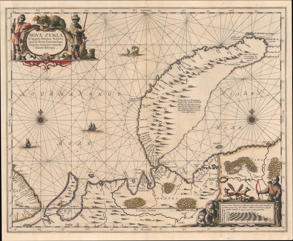
Nova Zemla, Waygats, Fretum Nassovicum, et Terra Samoiedum singula omnium emendatissimè descripta.
1650 (undated) 15.75 x 19.5 in (40.005 x 49.53 cm) 1 : 2729000
1650 (undated) 15.75 x 19.5 in (40.005 x 49.53 cm) 1 : 2729000
Description
This is an old color example of Jan Jansson's c. 1650 map and nautical chart of Novaya Zemlya in the Russian Far North, which appeared in the fifth volume of his Atlas Novus, also known as the 'Water World' atlas, the first true sea atlas. When this was issued, Novaya Zemlya was as hot in the European imagination as it was cold in fact. The archipelago was seen as a hopeful waypoint on the long-sought Northeastern Passage to Asia and was becoming increasingly popular with whalers.
The chart includes two stunning compass roses, numerous rhumb lines, a sea monster, and ships. The title cartouche and additional cartouche at the bottom-right contain illustrations of local wildlife, human figures meant to be Russian trappers or Cossacks and members of the area's indigenous peoples, and an explanation of the latitude lines on the map, accounting for the curvature of the Earth towards the poles. The place names and textual explanations on the map are a combination of Dutch, Latin, and Romanized Russian (such as 'Mourmanskoy More'). A group of Dutch names on the Russian mainland just south of the island reflect that nation's commercial aspirations in the region: Straet von Nassau, Nieu Hollant, Nieu Walcheren, Nieu West Frieslant.
A Closer Look
The map depicts the island of Nova Zembla or Nova Zemla in contemporary Western European sources, or Novaya Zemlya (Новая Земля) in Russian, meaning 'new land,' located in the Russian Arctic. Coverage ranges from the Kola Peninsula (including the city of Kola or Murmansk) in the west to the Yenisei River in the east, with the main focus being on the island of Novaya Zemlya and the Russian mainland immediately opposite to the south. The Arctic Circle is marked prominently at 66.5° N latitude. Towns and settlements are named throughout, with navigational and topographic features also noted, especially along the coasts (shoals, bays, cliffs, islands, and so on).The chart includes two stunning compass roses, numerous rhumb lines, a sea monster, and ships. The title cartouche and additional cartouche at the bottom-right contain illustrations of local wildlife, human figures meant to be Russian trappers or Cossacks and members of the area's indigenous peoples, and an explanation of the latitude lines on the map, accounting for the curvature of the Earth towards the poles. The place names and textual explanations on the map are a combination of Dutch, Latin, and Romanized Russian (such as 'Mourmanskoy More'). A group of Dutch names on the Russian mainland just south of the island reflect that nation's commercial aspirations in the region: Straet von Nassau, Nieu Hollant, Nieu Walcheren, Nieu West Frieslant.
Novaya Zemlya and the Search for a Northeast Passage
Throughout the 16th and 17th centuries, the concept of a Northeast Passage through the Arctic to Asia held the same significance as North America's Northwest Passage. The nations of Northern Europe, particularly Russia and Holland, were eager to find an easy route to Asia via the Arctic to access the lucrative trade with China and India. Willem Barentsz's first expedition in 1594, in which he discovered Novaya Zemlya and several other Arctic islands, was widely publicized in Europe and led to the assumption that a Northeast Passage may indeed be feasible. His second voyage in 1595 was considered a truncated failure due to inclement weather and ice packs in the Kara Sea. A year later, his third voyage in 1596 was an utter disaster when the sailors were trapped by ice on the northern part of Novaya Zemlya. The crew somehow survived the winter in a small cabin (marked here) built from timber salvaged from their ship; when the weather warmed somewhat, Barentsz's men used the ship's remaining timber to build two smaller vessels that they expected would be able to navigate the ice better. A harrowing summertime journey of seven weeks cutting through ice along the coast of the island allowed some of the men to be rescued and return to Holland to tell the tale, though Barentsz himself perished. In 1871, the Norwegian seal hunter Elling Carlsen rediscovered Barentsz's cabin on Novaya Zemlya - perfectly preserved due to the Arctic cold.Publication History and Census
This chart appeared in the fifth volume of Jansson's Atlas Novus, titled 'Atlantis Majoris Quinta Pars Orbem Maritimum...' (also known by its Dutch title 'Het Vijfde Deel Des Grooten Atlas, Vervatende De Water-Weereld'), commonly known as the 'Water World' atlas and constituting the first true sea atlas intended for a general audience. The blank verso here indicates a printing date of 1650, either the first Latin or German printing of the atlas. Both the map and the entire atlas volume are scarce, and examples in such lovely old color are even more so. The map is independently cataloged among the holdings of Harvard University, the Bibliothèque nationale de France, the National Library of Australia, and the University of Alaska Fairbanks in the OCLC, while the David Rumsey Historical Map Collection holds and has digitized the entire atlas volume.Cartographer
Jan Jansson or Johannes Janssonius (1588 - 1664) was born in Arnhem, Holland. He was the son of a printer and bookseller and in 1612 married into the cartographically prominent Hondius family. Following his marriage he moved to Amsterdam where he worked as a book publisher. It was not until 1616 that Jansson produced his first maps, most of which were heavily influenced by Blaeu. In the mid 1630s Jansson partnered with his brother-in-law, Henricus Hondius, to produce his important work, the eleven volume Atlas Major. About this time, Jansson's name also begins to appear on Hondius reissues of notable Mercator/Hondius atlases. Jansson's last major work was his issue of the 1646 full edition of Jansson's English Country Maps. Following Jansson's death in 1664 the company was taken over by Jansson's brother-in-law Johannes Waesberger. Waesberger adopted the name of Jansonius and published a new Atlas Contractus in two volumes with Jansson's other son-in-law Elizée Weyerstraet with the imprint 'Joannis Janssonii haeredes' in 1666. These maps also refer to the firm of Janssonius-Waesbergius. The name of Moses Pitt, an English map publisher, was added to the Janssonius-Waesbergius imprint for maps printed in England for use in Pitt's English Atlas. More by this mapmaker...
Source
Jansson, J., Atlantis Majoris Quinta Pars, Orbem Maritimum Seu Omnium Narium totius Orbis Terrarum Navigationibus hodierno tempore..., (Amsterdam: Jansson) c. 1650.
Condition
Fair. Verso stabilization to centerfold split and adjacent tears, as well as points of oxidization from old color. Corner, upper left, reattached.
References
Rumsey 10056.016. OCLC 934750581, 1012917342, 234135912. Van der Krogt, P. C. J., Koeman's Atlantes Neerlandici, 1270:1.