This item has been sold, but you can get on the Waitlist to be notified if another example becomes available, or purchase a digital scan.
1656 Jansson/Visscher Map of New England (Rare Second State)
NoviBelgii-visscher-1656-2$7,500.00

Title
Novi Belgii Novaeque Angliae nec non Partis Virginiae Tabula multis in locis emendata a Nicolao Joannis Visschero.
1656 (undated) 18.25 x 21.5 in (46.355 x 54.61 cm) 1 : 2200000
1656 (undated) 18.25 x 21.5 in (46.355 x 54.61 cm) 1 : 2200000
Description
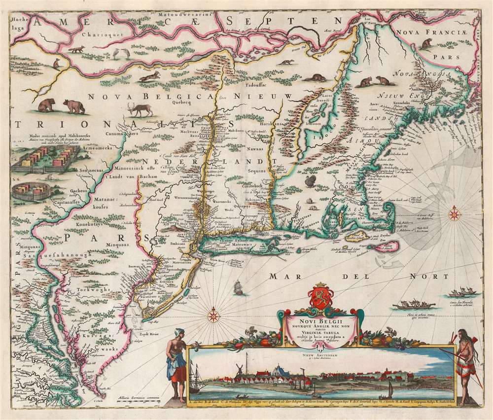
This is the rare, c. 1656 second state of the Jansson/ Visscher map of the New Netherlands and New England. It is the earliest acquirable state of this work: the first, 'proof state', of this masterwork is an unobtainable rarity, known in only four examples in institutional and private collections.
The Dutch rejected Sweden's colonial claims, asserting the Delaware River as part of New Netherland. The Dutch establishment of Fort Kasimier in 1651 was the first stage of Dutch efforts to re-establish control over their westernmost claims. The placement of Fort Kasimier cut off New Sweden from the ocean, and the protection of Nya Elfsborg. Fort Kasimier can be seen just downstream of the Swedish Fort Christina, as well as the upstream Swedish settlements. (The forts and settlements of Lapananel, Finland, Uppland, Mölndal, Nya Gothenborg, Gripsholm, Nya Vasa all appear on the west bank of the Delaware.) In 1654, New Sweden attacked and captured Fort Kasimier, expelling the Dutch from the Delaware Valley. That same year, the Swedes and Susquehannocks met to reaffirm their agreements. Thus, those agreements were in force when the Dutch, led by Pieter Stuyvesant, seized New Sweden between September 11 and 15, 1655. The Susquehannocks were swift to respond, with a series of attacks on Dutch settlements on the Hudson River. Six hundred warriors were able to attack New Amsterdam with virtual impunity before attacking Pavonia, Paulus Hook, Harlem, Staten Island, and the Bronx, taking hostages in Paulus Hook. (Adriaen van der Donck's own estate of Colen Donck was raided during the war, and it is possible though not certain that he was killed.) The captured settlers were ransomed for armaments and wampum. Settlements on the western bank of the Hudson were abandoned. The Susquehannock attack was a resounding success, but the message was lost on the Dutch. Although the Swedes knew the Susquehannocks were honoring their treaty and retaliating after the Dutch conquest of New Sweden, the Dutch believed the attacks were a retaliation for the killing of a young Wappinger woman by a Dutch settler. The Wappinges, established in Southern New York, were an Algonquian speaking people not at all associated with the Susquehannocks.
Suppression and Politics
This second state is most easily identifiable by the presence on the Delaware River of Fort Kasimier, but absence of Philadelphia. (Later states also include additional place names, such as Pennsylvania and 'Niew Jorck.') Despite - or perhaps due to - this map's superb detail and precision in its presentation of New Netherland, it was poorly disseminated. Neither the first nor the second state appeared in any of Visscher's atlases. Separately acquired examples have appeared tipped into Blaeu and Jansson atlases, but the map was not included in any of the Visscher family's atlases until the production of the third and fourth states. An irony, since by the time these 1684 states were printed the colony had been ceded to Great Britain and renamed New York - thus rendering them irrelevant (and perhaps this is the point). It is possible that there was at least some passive suppression of the map's publication, as no privilege is included until the fourth state. The association of this map with the Remonstrance of Adriaen van der Donck - who was engaged in protest against Pieter Stuyvesant's management of the New Netherlands colony - would have weighed against Visscher gaining a privilege for this work. Also, the outbreak of the First Anglo-Dutch War (1652 - 1654) may have dissuaded the Dutch from more broadly disseminating so revealing a map of one of the contested areas.Jansson's Northeast
The cartography for this map was drawn from the 1651 Jansson Belgii Novi, Angliae Novae, Et Partis Virginiae Novissima Delineatio. This so-called 'prototype' map was the first iteration of the dominant mapping of the Northeast and Mid-Atlantic well into the eighteenth century. It was first to approximate Manhattan and Long Island. It was also the first map to show Swedish settlements along the Delaware River, and the first compendium of regional Native American tribes encountered by the Dutch and the English. All maps of the Jansson-Visscher series ultimately take their model from the 1651 Jansson, which covered from the St. Lawrence River to the Chesapeake Bay, and from the Susquehanna River to the Penobscot, incorporating most of New England, New York, Pennsylvania, New Jersey, Virginia, Maryland, and Delaware.Firsthand Information for New Netherland
The heart of this map is the space falling between the Versche Rivier (Connecticut River) and the Zuydt River (Delaware). This was the area claimed by the Dutch as New Netherland, against the claims of England to the east, and Sweden to the srouthwest. The cartography is drawn from a large manuscript map, credited to Adrien van der Donck, used by New Netherlands colonists to protest negligence on the part of the Dutch West India Company (Geoctrooieerde Westindische Compagnie / GWC), the organization that formally owned New Netherland. Van der Donck, a lawyer, early resident of New Amsterdam, and the schout of Rensselaerwyck (Rensselaer), led the protest against Pieter Stuyvesant's policies. This accounts for the maps' remarkable detail of the Hudson valley as far north as the Mohawk River. The headwaters of the Mohawk are placed close to those of the Susquehanna River (some thirty miles separate the upper Mohawk River from Otsego Lake, the source of the North Branch of the Susquehanna). The placement of these rivers is reflective of the importance of the Hudson-Mohawk-Susquehanna circuit, a fur trading artery. It also highlights this map's relevance to the conflicts between Native American powers and the European newcomers. The Susquehannock tribe, in particular, appear prominently - indeed the Lenape of the Delaware River and New Amsterdam were by this time tributaries of the Susquehannock. Although an Iroquoian-speaking tribe, they were not part of the Iroquois 'Five Nations' league and were in fact at war with the Iroquois for much of the period in which this map was relevant. Although some elements of the Five Nations appear - the Seneca are named, and placed in the upper Susquehanna valley - the most prominent reference to the Iroquois is in the vicinity of the great 'Lacus Irocoisiensis' (Lake Champlain), here appearing far to the east of its actual location following the model of the 1612 Samuel de Champlain map.New Sweden, the Susquehannock, and the Peach Tree War
The key defining feature of this second state of the Jansson/Visscher map is the appearance, on the Delaware River, of Fort Kasimier. This Dutch fort was established in 1651 but appears neither on the c. 1655 first state nor on the 1651 Jansson 'Prototype' map. Its appearance here seems to coincide not with the building of the fort, but in its 1655 recapture from the Swedish.New Helvetica
Swedish settlement of the Delaware began with Dutch cooperation: their first settlement in 1638 of Fort Christina (Wilmington, Delaware) was led by Peter Minuit himself, who purchased the right to settle from the Susquehannocks. Susquehannock/Dutch relations were fragile, largely due to the Dutch-Iroquois alliance. New Sweden's proximity and relative vulnerability made them a much more attractive trade partner, and the Susquehannocks made New Sweden a protectorate and tributary while also becoming New Sweden's main supplier of furs and pelts.The Dutch rejected Sweden's colonial claims, asserting the Delaware River as part of New Netherland. The Dutch establishment of Fort Kasimier in 1651 was the first stage of Dutch efforts to re-establish control over their westernmost claims. The placement of Fort Kasimier cut off New Sweden from the ocean, and the protection of Nya Elfsborg. Fort Kasimier can be seen just downstream of the Swedish Fort Christina, as well as the upstream Swedish settlements. (The forts and settlements of Lapananel, Finland, Uppland, Mölndal, Nya Gothenborg, Gripsholm, Nya Vasa all appear on the west bank of the Delaware.) In 1654, New Sweden attacked and captured Fort Kasimier, expelling the Dutch from the Delaware Valley. That same year, the Swedes and Susquehannocks met to reaffirm their agreements. Thus, those agreements were in force when the Dutch, led by Pieter Stuyvesant, seized New Sweden between September 11 and 15, 1655. The Susquehannocks were swift to respond, with a series of attacks on Dutch settlements on the Hudson River. Six hundred warriors were able to attack New Amsterdam with virtual impunity before attacking Pavonia, Paulus Hook, Harlem, Staten Island, and the Bronx, taking hostages in Paulus Hook. (Adriaen van der Donck's own estate of Colen Donck was raided during the war, and it is possible though not certain that he was killed.) The captured settlers were ransomed for armaments and wampum. Settlements on the western bank of the Hudson were abandoned. The Susquehannock attack was a resounding success, but the message was lost on the Dutch. Although the Swedes knew the Susquehannocks were honoring their treaty and retaliating after the Dutch conquest of New Sweden, the Dutch believed the attacks were a retaliation for the killing of a young Wappinger woman by a Dutch settler. The Wappinges, established in Southern New York, were an Algonquian speaking people not at all associated with the Susquehannocks.
The Visscher View
This is the earliest glimpse afforded the collector of this very early view of New Amsterdam, the colonial town that would become New York. This dramatic view of the southern tip of Manhattan was based upon a 1648 watercolor, now in Vienna's Albertina, attributed to Augustin Herman (c. 1621 – 1686). The watercolor view was first committed to print by Joan Blaeu for presentation with Van der Donck's 1650 Remonstrance. The view's addition to this map by Visscher would prove far more visible than the Remonstrance, and thus the illustration became known, somewhat erroneously, as the 'Visscher View.' Authorship and appellation notwithstanding, this is the earliest view of Manhattan available to the collector. Philip Burden considers the map 'of extreme importance' for its inclusion of the view. Its appearance here - without any defensive palisade - reveals the vulnerability that contributed to Susquehannock successes in the 'Peach Tree War.'Publication History and Census
This map was engraved by N. J. Visscher c. 1655 but was not included in any of the Visscher atlases until the heavily amended c. 1684 edition published by Nicolas Visscher II. This example is the c. 1656 second state, per Burden and Tooley. The map names Fort Kasimier, which was lacking on the 1655 first state, but does not show Philadelphia, which does not appear until the 1684 third state. Both the first and second states bear the imprint Nicolao Joannis Visschero. The third and fourth states bear the imprint of his son, per Nicolaum Visscher. Early, pre-atlas states are rare. We see only ten examples of this state of the map cataloged in institutional collections.CartographerS
Claes Jansz Visscher (1587 - 1652) established the Visscher family publishing firm, which were prominent Dutch map publishers for nearly a century. The Visscher cartographic story beings with Claes Jansz Visscher who established the firm in Amsterdam near the offices of Pieter van den Keer and Jadocus Hondius. Many hypothesize that Visscher may have been one of Hondius's pupils and, under examination, this seems logical. The first Visscher maps appear around 1620 and include numerous individual maps as well as an atlas compiled of maps by various cartographers including Visscher himself. Upon the death of Claes, the firm fell into the hands of his son Nicholas Visscher I (1618 - 1679), who in 1677 received a privilege to publish from the States of Holland and West Friesland. The firm would in turn be passed on to his son, Nicholas Visscher II (1649 - 1702). Visscher II applied for his own privilege, receiving it in 1682. Most of the maps bearing the Visscher imprint were produced by these two men. Many Visscher maps also bear the imprint Piscator (a Latinized version of Visscher) and often feature the image of an elderly fisherman - an allusion to the family name. Upon the death of Nicholas Visscher II, the business was carried on by the widowed Elizabeth Verseyl Visscher (16?? - 1726). After her death, the firm and all of its plates was liquidated to Peter Schenk. More by this mapmaker...
Jan Jansson or Johannes Janssonius (1588 - 1664) was born in Arnhem, Holland. He was the son of a printer and bookseller and in 1612 married into the cartographically prominent Hondius family. Following his marriage he moved to Amsterdam where he worked as a book publisher. It was not until 1616 that Jansson produced his first maps, most of which were heavily influenced by Blaeu. In the mid 1630s Jansson partnered with his brother-in-law, Henricus Hondius, to produce his important work, the eleven volume Atlas Major. About this time, Jansson's name also begins to appear on Hondius reissues of notable Mercator/Hondius atlases. Jansson's last major work was his issue of the 1646 full edition of Jansson's English Country Maps. Following Jansson's death in 1664 the company was taken over by Jansson's brother-in-law Johannes Waesberger. Waesberger adopted the name of Jansonius and published a new Atlas Contractus in two volumes with Jansson's other son-in-law Elizée Weyerstraet with the imprint 'Joannis Janssonii haeredes' in 1666. These maps also refer to the firm of Janssonius-Waesbergius. The name of Moses Pitt, an English map publisher, was added to the Janssonius-Waesbergius imprint for maps printed in England for use in Pitt's English Atlas. Learn More...
Adriaen Cornelissen van der Donck (c.1618 – 1655) was a Dutch lawyer, schout (attorney-general,) author, and political gadfly active in New Netherland during Pieter Stuyvesant's tenure as. Van der Donck's noble honorific, Jonkheer gives the city of Yonkers its name. He was an active promoter of immigration to the colony, and his Description of New Netherland would provide the fullest available account of the colony, its geography, and the Native American peoples inhabiting it. Van der Donck's political campaigning against Stuyvesant (and the Dutch West India Company) ]would result, incidentally, in some of the most long-lived and influential cartographic representations of the New Netherland colony to be produced in the seventeenth century.
Van der Donck was born in Breda in the southern Netherlands to a prosperous and well connected family: he studied civil and canon law at the University of Leiden. Upon receiving his degrees he entered the service of the patroon Kiliaen van Rensselaer, securing a post as schout in the patroonship of Rensselaerswijck (near modern Albany.) Van der Donck sailed for his new home in 1641. Almost immediately, his interpretation of his duties began to conflict with those of the Patroon - rather than serving as Van Rensselaer's enforcer, van der Donck increasingly worked to advocate for colonists and their interests. He also developed relations with the Native inhabitants, learning their language and recording their customs. When its term expired in 1644, Van der Donck's contract with Van Rensselaer was not renewed. Relocating to New Amsterdam, van der Donck would lend his assistance to then-Director-General Willem Kieft in his efforts to negotiate peace with the Lenape and Wappinger Indians. In return, Kieft granted van der Donck 24,000 acres in the area of modern day Yonkers, where van der Donck would establish his estate of Colen Donck. Far from being made an ally, van der Donck covertly undertook a campaign against Kieft to make a case for the creation in New Netherland of a local, representative government based on the Dutch model. The campaign succeeded in Kieft's removal, but rather than establishing representative government, the company decided to install a strong man to stamp out dissent, in the person of Peter Stuyvesant. Dutch tradition prevented Stuyvesant from achieving pure autocracy: he was compelled to accept the creation of an advisory board - the Nine Men - among whom Van der Donck would become a leader. His efforts to give voice to colonial grievances against the West India Company, Kieft, and Stuyvesant would result in van der Donck's house arrest and removal from the Nine Men. Nevertheless, he was among the three men chosen to sail to the Netherlands to petition the States General with the case that the valuable colony stood in danger of being lost due to Dutch West India Company mismanagement. In the Netherlands, van der Donck's campaigns would result in the publication of pamphlets (notably his 1650 Remonstrance) and in the production of the seminal Jansson 'Prototype' map of New Netherland and the so-called 'Visscher view' of Manhattan. Van der Donck's efforts were at first successful - in 1652 the West India Company was ordered to create a more liberal, municipal government to encourage emigration and to recall Stuyvesant to the Netherlands, which van der Donck was to personally deliver to the Director-General. Before van der Donck could board ship, the First Anglo-Dutch War broke out. The States General, wishing to lose neither a Stuyvesant nor the West India Company in a time of war, rescinded their decision; van der Donck was refused passage back to New Netherland. Prevented from his return, he instead took a further law degree at Leiden and wrote a new, comprehensive description of New Netherland, further promoting the colony. (He completed the work in 1653, but it would not be published until 1655 on account of the war.) Van der Donck was not permitted to return to New Netherland until May 26, 1653 on the condition he retire from public life; he appears also to have been prevented from actively practicing the law. The particulars of his death are not known. He was alive in the summer of 1655; by January of 1656 he was referred to as deceased. It is known that his estate was among those raided during the September 1655 'Peach Tree War' and it is possible that he was killed in the violence. Learn More...
Condition
Very good. Right, left and top margins extended with no impact on printed image. Mend at lower centerfold with very slight loss. Original color refreshed; heightened with gold.
References
Compare to Rumsey 11755.125 (4th state). Burden, P., The Mapping of North America 315, state 2. Tooley, R. V., The Mapping of America, no. 5, p. 284. Augustyn / Cohen Manhattan in Maps, pp. 32-33. De Koning, J. 'From Van der Donck to Visscher' in Mercator’s World, July/August 2000, pp. 28-33.