This item has been sold, but you can get on the Waitlist to be notified if another example becomes available, or purchase a digital scan.
1890 Matthews Northrop Map of Northern Pacific R.R. in Washington and Oregon
NPRRLandGrant-matthewsnorthrup-1890$375.00

Title
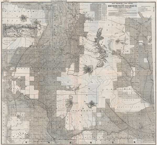
Map Showing Land Grant of the Northern Pacific Railroad Co. in Western Washington and Northern Oregon.
1890 (dated) 34.75 x 32.25 in (88.265 x 81.915 cm) 1 : 380160
1890 (dated) 34.75 x 32.25 in (88.265 x 81.915 cm) 1 : 380160
Description
This is an 1890 Matthews. Northrop, and Company Northern Pacific Railroad map of western Washington state and northern Oregon. The map depicts the region from the Pacific Ocean to the Columbia River and from the Strait of Juan de Fuca to the Portland. Nearly all of the map is divided into townships, with each township subsequently divided into thirty-six sections. Within each township, sections number sixteen and thirty-six are 'school sections', land set aside for construction of schools. The land within each township, aside from the school sections, is also labeled. Per the map, each section originally belonged to either the Northern Pacific Railroad for the federal government. Squares filled in with diagonal lines represent Northern Pacific Railroad land, while blank squares denote U.S. government land. Squares which contain a white (or blank) circle were Northern Pacific Railroad lands, which the N.P.R.R. has sold.
Several cities and towns are labeled throughout, including Tacoma, Seattle, Olympia, and Vancouver, Washington, and Portland, Oregon. Numerous other small towns are also labeled. The Cascade Mountains traverse the map just to the right of center, creating a swath of land not divided into townships. Mt. Adams, Mt. St. Helens, and Mt. Tacoma are all labeled, along with several mountain passes and various mines extracting different resources from the mountains. An inset map, illustrating the route of the Northern Pacific Railroad from Minneapolia-St. Paul to Portland, Tacoma, and Seattle, along with the route of the Oregon and California Railroad, is situated along the left border.
As is stated in the condition statement, this map has been backed on archival tissue for stability. Even so, all of the verso content is legible. Features of the verso include in-depth descriptions of the Western and Central Washington, along with detailed descriptions of different regions within those two areas. Details concerning mining, logging, and other industries are also provided. Advice for prospective settlers on how to begin their journey and where to look for land for their new homestead is included as well, along with the sincere belief (per the Northern Pacific Railroad) that the best way to reach Washington and Oregon is by rail operated by the Northern Pacific Railroad from Minneapolis-St. Paul. Information on land pricing and terms can also be found.
This map was produced and published by Matthews, Northrup, and Company of Buffalo, New York for the Northern Pacific Railroad and corrected up to April 1, 1890.
Cartographer
Matthews-Northrup Works (fl. c. 1895 - 1930) were a Buffalo, New York based, in their own words, "writing, designing, engraving, printing, [and] binding" firm. The firm was founded by James Newson Matthews (November 21, 1828 - December 20, 1888) as the J. N. Matthews Company. William Phelps Northrup (April 2, 1850 - February 2, 1929) later joined the company as an apprentice and then partner, at which point the firm was reincorporated as the Matthews-Northrup Works. The Matthews-Northrup Works rose to prominence as publishers and printers of railroad maps, with dozens to their credit. When James died, his shares were inhered by George Edward Matthews (1855 - 1910), who ran the business until his death in 1910. Also in 1910, they famously redesigned the cover of National Geographic Magazine. Despite some six previous cover changes in just 21 years, the Matthews-Northrup layout proved so popular that it was used for nearly 50 years. The firm can also take credit for the Winchell typeface, designed in 1903 under E. E. Winchell's tenure as art director. Curiously, the partners of Matthews-Northrup maintained an unusual affectation in which only the officers of the company could wear beards or mustaches. In this same spirit, the firm also had its own private social club, the Fellowcraft Club, where the all-male employees could relax, play pool, drink and dine. Matthews-Northrup maintained offices on Washington Street, Buffalo, where they were based, as well as Madison Square, New York City, Garden Tower, Boston, and the Citizens Building in Cleveland. More by this mapmaker...
Condition
Very good. Wear along original fold lines. Backed on archival tissue for stability. Text on verso.