This item has been sold, but you can get on the Waitlist to be notified if another example becomes available, or purchase a digital scan.
1574 Ruscelli Map of Mexico, California, Florida and the Gulf of Mexico
NuevaHispania-ruscelli-1561$625.00

Title
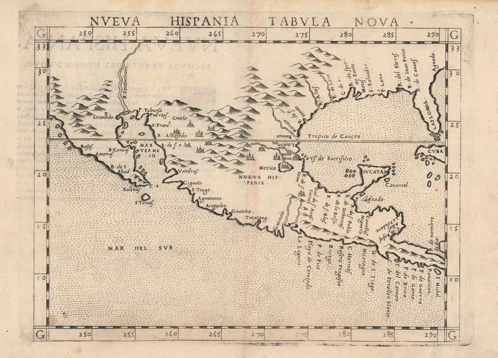
Nueva Hispania Tabula Nova.
1561 (undated) 7.5 x 9.5 in (19.05 x 24.13 cm) 1 : 19000000
1561 (undated) 7.5 x 9.5 in (19.05 x 24.13 cm) 1 : 19000000
Description
This is Girolamo Ruscelli's 1574 map Tierra Nveva, an early and influential map of what would become Mexico, California, Texas, and Florida. Ruscelli's work is an enlarged and improved version of the 1548 map of the same region by fellow Venetian Giacomo Gastaldi. Apart from the Gastaldi, Ruscelli's map is the earliest to focus so closely on the southern parts of what would become the United States and is one of the earliest acquirable maps to reflect Spanish exploration and colonization in the Americas. Overall, along with the map covering the East Coast north of Florida, this is among the earliest maps to focus on North America.
The Scope
The west coast is depicted, with a peninsular California, from twenty-five degrees north down to the coast of Panama; the east embraces Florida, all of the Gulf of Mexico, and names the Nombre de Dios on the Caribbean coast of Panama. The western part of Cuba appears and is named. Yucatan is illustrated as a peninsula, a material improvement on the 1548 Gastaldi which portrayed it as an island. Inland, Mexico City is named, along with the legendary Civola.Publication History and Census
This map was first published by Girolamo Ruscelli for the 1561 first edition of his Geography of Claudius Ptolemy, La Geografia di Claudio Tolomeo. It was engraved by Giulio Sanuto for inclusion in the 1561 Ruscelli Ptolemy, and remained in print for the various editions of the work. The maps of this edition were engraved two-to-a-plate, and consequently the platemark runs off the edge of the sheet at top on first state examples of the map. By the time this 1574 edition was printed, the plates had been cut in two. Thus, later examples such as the present one exhibit a platemark all the way around. The engraving was also retooled in 1574, with crosshatching added to the graduation marks. A third state appeared in 1598 with several significant geographical revisions, including the addition of a ship, along with the placenames 'Siera Nevad' and 'Calmifor'. The 1598 issue also renames 'Mar Del Sur' as 'Mare Pacificum,' and names the Gulf of Mexico. This map comes to the market from time to time and is well represented in institutional collections as a staple of early North America cartography.CartographerS
Girolamo Ruscelli (1500 - 1566) was an Italian polymath, humanist, editor, and cartographer active in Venice during the early 16th century. Born in Viterbo, Ruscelli lived in Aquileia, Padua, Rome and Naples before relocating to Venice, where he spent much of his life. Cartographically, Ruscelli is best known for his important revision of Ptolemy's Geographia, which was published posthumously in 1574. Ruscelli, basing his work on Gastaldi's 1548 expansion of Ptolemy, added some 37 new "Ptolemaic" maps to his Italian translation of the Geographia. Ruscelli is also listed as the editor to such important works as Boccaccio's Decameron, Petrarch's verse, Ariosto's Orlando Furioso, and various other works. In addition to his well-known cartographic work many scholars associate Ruscelli with Alexius Pedemontanus, author of the popular De' Secreti del R. D. Alessio Piemontese. This well-known work, or "Book of Secrets" was a compilation of scientific and quasi-scientific medical recipes, household advice, and technical commentary on a range of topics that included metallurgy, alchemy, dyeing, perfume making. Ruscelli, as Alexius, founded a "Academy of Secrets," a group of noblemen and humanists dedicated to unearthing "forbidden" scientific knowledge. This was the first known experimental scientific society and was later imitated by a number of other groups throughout Europe, including the Accademia dei Secreti of Naples. More by this mapmaker...
Giulio Sanuto (fl. 1540 – 1580) was a Venetian engraver. He was born the illegitimate son of Cavaliere Francesco di Angelo Sanuto; With his brother, the cartographer and scientific instrument maker Livio Sanuto (1520 – 1576) he produced an array of some of the most important geographical works produced in Venice during the second half of the sixteenth century. These included a 27-inch globe and the 1588 12-sheet atlas, Geografia della Africa. Giulio's career is singluar among Venice's engraves in that it appears to have been equally based on artistic, figurative work as well as his cartographic works. Giulio is more broadly known for a small but sought-after selection of decorative engravings; no more than twelve of these can be attributed confidently to him, including the monumental Apollo and Marsyas, measuring over 1.30 meters wide. Whilst Sanuto's engravings were generally based upon the designs of other artists, his work was both ambitious and grand, and he often signed these works. Learn More...
Source
Ruscelli, G., La Geografia di Claudio Tolomeo Alessandrino…, (Venice: Giordano Ziletti) 1574.
Beginning in 1561, Girolamo Ruscelli published this important, expanded edition of Giacomo Gastaldi's 1548 Ptolemy. Its maps, engraved in Venice by Giulio Sanuto, were in the main based directly upon those in Gastaldi's 1548 work. The maps were larger format than Gastaldi's, however, and Sanuto's engraving was far clearer and more legible than those appearing in the 1548 work. There are some important additions that distinguish Ruscell's Ptolemy from Gastaldi's. Ruscelli's work contained a map of the habitable world according to Ptolemy, which the Gastaldi lacked; also, the double-hemisphere map appearing in the Ruscelli was new and did not appear in the Gastaldi. Ruscelli's modern map of England was based on the work of George Lily, rather than the Waldseemüller-derived map appearing in the Gastaldi; the Ruscelli is the earliest generally acquirable map of England based on knowledge from someone who lived there. In a fateful innovation, Ruscelli's work included Septentrionalium partium nova tabula,the first copy of Nicolo Zeno's 1558 fraud Carta da Navegar, which introduced a novel mapping of the north parts of the world, including the phantom islands of Frisland, Icaria, Drogeo and Estotiland. Had Ruscelli not copied the Zeno - which had a narrow, brief publication - this preposterous geography would have probably not taken hold. Its inclusion in Ruscelli's beautiful, authoritative and popular work would lead to the adoption of the Zeno map by Mercator, Ortelius, Plancius and their successors, baffling scholars for centuries. Ruscelli's Ptolemy had a long publication history, cementing the influence of the work. It appeared both in Italian and Latin editions, all printed in Venice, throughout the latter 16th century:
- 1561 La Geographia di Claudio Tolomeo Alessandrino, Italian. Venice, Vincenzo Valgrisi.
- 1562 Geographia Cl. Ptolemaei Alexandrini, Latin. Venice, Vincenzo Valgrisi.
- 1564 La Geographia di Claudio Tolomeo Alessandrino, Italian. Venice, Giordano Ziletti.
- 1564 Geographia Cl. Ptolemaei Alexandrini, Latin. Venice, Giordano Ziletti.
- 1574 La Geographia di Claudio Tolomeo Alessandrino, Italian. Venice, Giordano Ziletti.
- 1598 Geographia di Claudio Tolomeo Alessandrino, Italian. Venice, heirs of Melchoir Sessa.
- 1599 Geographia di Claudio Tolomeo Alessandrino, Italian. Venice, heirs of Melchoir Sessa.
Condition
Very good. Marginal mend at bottom center well away from printed image, else excellent.
References
Burden, P., The Mapping of North America, #31. OCLC 500422218.