
1890 Dosseray Wall Map of Europe

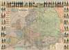
Nuevo Mapa de Europa Politico y Comercial Ilustrado con los Tipos y Uniformes Militares de los Estados de Europa.
European military uniforms and more.
$1,000.00
Choose a Collection:
- Digital Map Information
- Suitable for large format printing
- Full resolution TIFF file
- ICC color profile embedded
- Delivered instantly via download link
This Item
Enquire
European military uniforms and more.
This is an 1890 Jean Dosseray wall map of Europe. A political map of Europe occupies most of the sheet, with countries, cities, towns, rivers, and more all identified. Europe's rail is highlighted, underscoring its ever-growing importance. Eighteen European flags with population statistics appear in an inset at the upper left. An inset in the lower right focuses on the Suez Canal and the Nile Delta in Egypt, underscoring the canal's strategic importance to European powers.Men in Uniform
Along three sides, vignettes illustrate the military uniforms of seventeen European nations. Spain's military occupies the entire top border, with uniforms from every branch of service represented. England, Russia, Germany, Portugal, and Belgium rank among the countries depicted on the left and right sides.Publication History and Census
This map was created and published by Jean Dosseray in Brussels in 1890 and sold in Spain and Portugal by Francisco Nogues. This is the only known example of the 1890 edition of this map. We note a single OCLC reference for this map in its 1889 edition (Universitat de València). We also note a single example of a very similar, possibly pirated, variant published by Gadola (Paris, 1914).Cartographer
Jean Dosseray (1868 - 1904) was a Belgian publisher and editor active in Brussels during the late 19th century. He published science-based maps for schools and tourists. Further Details...
Condition
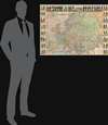
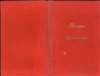
Very good. Dissected and mounted on linen in thirty-six (36) panels. Accompanied by original binder.
References
OCLC 969602824 (1889).