This item has been sold, but you can get on the Waitlist to be notified if another example becomes available.
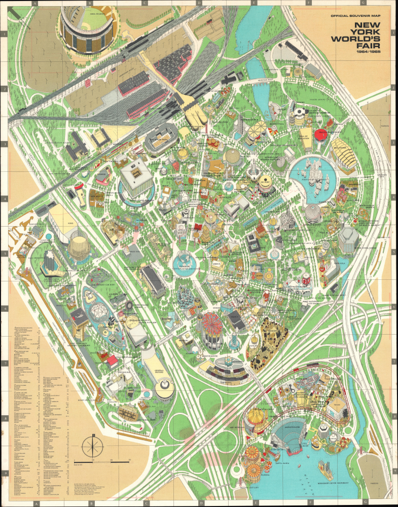
1964 Bollman View of the New York World's Fair Grounds, Flushing Meadows Park
NYWorldsFair-bollman-1964$150.00


Title
Official Souvenir Map New York World's Fair 1964/1965.
1964 (dated) 33 x 26 in (83.82 x 66.04 cm) 1 : 2500
1964 (dated) 33 x 26 in (83.82 x 66.04 cm) 1 : 2500
Description
This is Herman Bollmann's 1964 pictorial bird's-eye view of the grounds of the 1964 New York World's Fair. Despite the contentious origins and questionable financing of the fair, it was fondly remembered by attendees for its distinctive Space Age futuristic aesthetic.
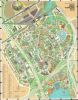
The verso contains a map of New York City highlighting subway lines from Midtown Manhattan to the vicinity of the fair, highways, airports, bridges, tunnels, and hotels and attractions in Midtown Manhattan. An inset map displays highways and public transportation connections around the fairgrounds. Although these highways predated the fair, they were widened, upgraded, and better interconnected in preparation for the event.
Moses gave considerable assistance to the fair, hoping it would develop Flushing Meadows Park and the surrounding area, which had seen numerous housing and business projects flounder because of the distance from Manhattan and perceived undesirability of the area. He had for decades been trying to jumpstart development in the area, and the fair, along with the opening of Shea Stadium (which he masterminded) and the expansion of the nearby highways mentioned above seemed to portent future success. Moses also appealed to (or rather, hectored) the BIE to recognize the fair, which they could not do as it violated several of their policies, though they allowed it to go ahead without opposition. Nevertheless, Moses' aggressive behavior so irritated the BIE that it quickly awarded a competing, officially approved fair to Seattle for 1962.
In the end, the 1964 New York World's Fair was an ad hoc and shoestring affair, which overpromised and underdelivered. It was financed through bonds that the organizers were generally unable to pay back. Ultimately, over 51 million people attended the fair, undoubtedly a good turnout but significantly short of the hoped-for 70 million. The Unisphere metal frame globe fountain was the central attraction and remains an architectural oddity, but most of the fair's pavilions were quickly bulldozed and dumped into Flushing Bay. In the eyes of the public, however, attendees enjoyed the fair's futuristic Jet Age aesthetic, which included a monorail, Space Park, and several distinctive pavilions, such as the General Motors' pavilion with a 110-foot-tall, tilted concrete façade (at bottom-left here).
A Closer Look
This view covers the grounds of the 1964 World's Fair in Flushing Meadows Park in Queens, New York City. At top, beyond the official fairgrounds, is the Willets Point IRT Subway Station, the Long Island Railroad, and other transportation facilities, as well as Shea Stadium, also opened in 1964. Below are the pavilions and exhibits of the fairgrounds proper, which were sponsored by American corporations, individual American states, and foreign countries. As was standard for international expositions, the fair organizers also built thematic pavilions to highlight technology and culture. A grid surrounds the view, corresponding to an index at bottom-left.The verso contains a map of New York City highlighting subway lines from Midtown Manhattan to the vicinity of the fair, highways, airports, bridges, tunnels, and hotels and attractions in Midtown Manhattan. An inset map displays highways and public transportation connections around the fairgrounds. Although these highways predated the fair, they were widened, upgraded, and better interconnected in preparation for the event.
1964 - 1965 New York World's Fair
The 1964 - 1965 New York World's Fair was held in Flushing Meadows-Corona Park, previously the site of the 1939-1940 New York World's Fair. The fair took place over two six-month seasons during the summer and early fall of 1964 and 1965. New York businessmen organized the fair without the approval of the Bureau International des Expositions (BIE). Nevertheless, New York City Mayor Robert F. Wagner Jr. and, more importantly, the Parks Commissioner and 'power broker' Robert Moses approved the plan, as did President Eisenhower, and construction began in 1960.Moses gave considerable assistance to the fair, hoping it would develop Flushing Meadows Park and the surrounding area, which had seen numerous housing and business projects flounder because of the distance from Manhattan and perceived undesirability of the area. He had for decades been trying to jumpstart development in the area, and the fair, along with the opening of Shea Stadium (which he masterminded) and the expansion of the nearby highways mentioned above seemed to portent future success. Moses also appealed to (or rather, hectored) the BIE to recognize the fair, which they could not do as it violated several of their policies, though they allowed it to go ahead without opposition. Nevertheless, Moses' aggressive behavior so irritated the BIE that it quickly awarded a competing, officially approved fair to Seattle for 1962.
In the end, the 1964 New York World's Fair was an ad hoc and shoestring affair, which overpromised and underdelivered. It was financed through bonds that the organizers were generally unable to pay back. Ultimately, over 51 million people attended the fair, undoubtedly a good turnout but significantly short of the hoped-for 70 million. The Unisphere metal frame globe fountain was the central attraction and remains an architectural oddity, but most of the fair's pavilions were quickly bulldozed and dumped into Flushing Bay. In the eyes of the public, however, attendees enjoyed the fair's futuristic Jet Age aesthetic, which included a monorail, Space Park, and several distinctive pavilions, such as the General Motors' pavilion with a 110-foot-tall, tilted concrete façade (at bottom-left here).
Publication History and Census
This view was prepared by German cartographic artist Herman Bollmann in 1964 for Time Inc. It seems to have been produced in several iterations, including separately issued, folding into a soft cover, and as part of packet with Bollman's better-known axonometric bird's eye view of Midtown Manhattan (previously sold by us) and a subway map. However, this example is a separately issued 'deluxe edition' of the official souvenir map, finished in plastic and sent to the buyer rolled in a tube. Some examples of the view have a blue border rather than white, though an explanation for this variation is elusive. Due to these complicating factors, the view is listed in four separate catalog listings in the OCLC, and these do not always clearly distinguish between the different iterations of the view.Cartographer
Herman Bollmann (1911 - 1971) was a German cartographer and map maker active from roughly 1940 to 1970. Before World War II, Bollmann was a well-known woodcarver and engraver based in Braunschweig, Germany. Following the war, Bollmann developed a reputation as a printer of unique three-dimensional maps. Working over a period of 25 years, Bollmann established a reputation as an artistic cartographer, producing over 39 unique projections of various cities in Europe and America. Bollmann revived the 19th-century cartographic technique known as Vogelschaukarten, a way of making three-dimensional axonometric projections. Bollmann and his team relied heavily on aerial cartography to compose distinctive cartographic masterpieces that are coveted by collectors all over the world. More by this mapmaker...
Condition
Good. Plastic finish on both sides. Light soiling and offsetting. Accompanied by original tube.
References
OCLC 9532548, 1488344109, 953572921, 78364402.