This item has been sold, but you can get on the Waitlist to be notified if another example becomes available, or purchase a digital scan.
1921 Matsu Road Map of Oahu, Hawaii
Oahu-matsu-1921-2$225.00

Title
1921 Matsu Road Map of Oahu, Hawaii.
1921 (dated) 13.25 x 17 in (33.655 x 43.18 cm) 1 : 177000
1921 (dated) 13.25 x 17 in (33.655 x 43.18 cm) 1 : 177000
Description
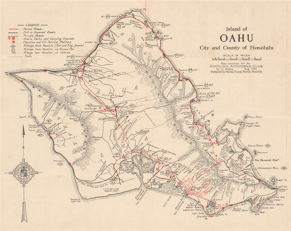
This is a 1921 U. Matsu map of the island of Oahu in the Hawaiian Archipelago. The map depicts the entire island in full, from Kaena Point to Makapuu Point and from Kahuku Point to Diamond Head.
Mormon Settlement of Laie
The Mormon settlement at Laie is labeled. Historically, Laie had been an important location in native Hawaiian culture. A new era in the history of the region began in 1865 when George Nebeker, the president of the Hawaiian Mission of the Church of Jesus Christ of Latter-day Saints purchased the plantation of that name and then encouraged all members of the LDS community in Hawaii to move to Laie. Not long after the purchase, a sugar factory was built. Significantly, this plantation was one of the few that grew both kalo and sugar simultaneously; an important achievement because kalo and sugar have high water demands. This rarity occurred because native Hawaiian workers insisted on growing kalo, a staple in the Hawaiian diet. Both schools and church buildings were built in the community in the following years. The Hawaiian Mission moved to Honolulu in 1919, but the temple at Laie had already been built, thus the town remained the spiritual center of the Latter-day Saints community in Hawaii.Roads and Transportation
Compiled by Matsu for the Honolulu Automobile Club, the island's road network is prominently featured. Paved roads (drawn in red), dirt and unpaved roads (shown in black), and private roads (marked by black dashed lines) are illustrated throughout the island. Numerous trails are also illustrated by dotted lines, though it is unclear if these trails are footpaths or meant for off-roading. Distances (mileage) to Honolulu are indicated throughout the island using three different notations. Distances given in diamonds are distances from that point straight to Honolulu, while those enclosed in circles are distances via Nuuanu Pali, northeast of Honolulu. Finally, mileage indicated without any symbol is the mileage from that point to Honolulu via Haleiwa, a town situated on the northeast coast of Oahu. Private parks, camping grounds, and gasoline and oil service stations are also marked on the map, giving any motorist out on a Sunday drive the ability to know where they can stop to relax or to refuel. A legend, situated in the upper left corner, explains all these notations.Elsewhere on the Map
Oahu is divided into six different administrative districts, each of which are illustrated and labeled. Plantations, points, beaches, wireless stations, mills, and other locations of interest are labeled as well. Pearl Harbor, the wonderful natural harbor where the Pacific Fleet would be based twenty years after this map was created, is illustrated in detail. Luke Field, the first airfield on Ford Island, is labeled as well. This airfield would be replaced by Hickam Army Airfield in 1939 and Luke Field was ceded to the U.S. Navy. Luke Field would be renamed Naval Air Station Ford Island.Publication History and Census
This map was compiled by U. Matsu for the Honolulu Automobile Club in August 1921 and published by the Hawaii Tourist Bureau. Three examples are cataloged in OCLC and are part of the institutional collections at the Wisconsin Historical Society, the Danish Union Catalogue, and the Royal Danish Library.Cartographer
Umiumi Matsu (July 18, 1883 - October 30, 1925) was a draftsman active in Hawaii in the early 20th century. Matsu first appears in Oahu city directories in 1902 as a clerk for the first land district. In 1909, Matsu was working as a clerk for the Hilo Railroad Company. The following year he is listed as a chainman for the road department in Hilo. He was working as a surveyor for the Thomas Cook Company in Hilo in 1911 and in 1912 he was working as a draftsman for the Loan Fund Commission in Hilo. A year later, in 1913, Matsu began working as a draftsman for the department of public works, where he worked until at least 1920. He created at least one commercial map during his lifetime: a road map of Oahu for the Honolulu Automobile Club. Aside from the entries in the Oahu city directories, we have been unable to unearth very little information about Matsu's life. More by this mapmaker...
Condition
Very good. Exhibits light wear along original fold lines. Text on verso.
References
OCLC 871554114.