This item has been sold, but you can get on the Waitlist to be notified if another example becomes available, or purchase a digital scan.
1827 Vandermaelen / Humboldt Map of Oaxaca and Chiapas States in Mexico
OaxacaChiapas-vandermaelen-1827$540.00

Title
Partie du Mexique et de Guatemala. Amer. Sep. no. 71.
1827 (undated) 18.25 x 21.5 in (46.355 x 54.61 cm) 1 : 1641836
1827 (undated) 18.25 x 21.5 in (46.355 x 54.61 cm) 1 : 1641836
Description
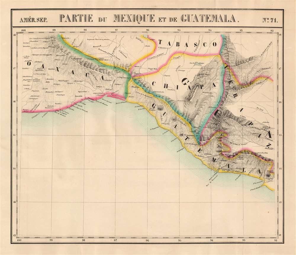
This is the 1827 Vandermaelen map of southern Mexico and western Guatemala. Vandermaelen's Atlas Universel was the first lithograph atlas as well as the first whose maps were printed on a universal scale. The present map was the first lithograph map of its region, and it is the earliest map to focus so narrowly on the states of Chiapas and Oaxaca. The map also includes the southern part of Tabasco, part of Veracruz, and part of Guatemala. The precursor is Arrowsmith's 1810 A New Map of Mexico and Adjacent Provinces Compiled from Original Documents, one of the first maps to present Alexander von Humboldt's mapping of Mexico.
Oaxaca
The state of Oaxaca is shown from Mixtepec and Bajos de Chila on the Pacific Coast, and as far north as San Juan de los Cues (which is noted as an Aztec ruin). In addition to the city of Oaxaca, the map notes Puerto Escondido, Mazunte, Tehuantepec, San Miguel Chimalapa, and many other towns. While the mountains between central Oaxaca and the coast are only hinted at, the region's Sierra Norte is dramatically depicted - continuing well to the south as the Sierra Madre de Chiapas.Tabasco and Chiapas
Throughout the colonial period, both the future states of Tabasco and Chiapas had a thin European population, and consequently were extremely poorly understood geographically. This condition continued into the early Independence period, leading to both a lack of data in the maps of that period and considerable errors. In spite of this, Vandermaelen's map captures a crucial and sometimes baffling historical period. Although these areas would become part of Mexico following independence, Vandermaelen's map clearly marks Chiapas, neighboring Verapaz, and coastal Chiapas as part of Guatemala. This is consistent with the 1810 Arrowsmith. It later appeared this way in the 1828 Disturnell map of Mexico: thus Vandermaelen reflects the state of the art of the mapping of this fluid border region. During the colonial era, Chiapas was part of Captaincy General of Guatemala. Following independence, some Chiapas merchants in Chiapanecan towns attempted to establish a separate Chiapas; while others favored unification with Guatemala, particularly in Soconusco. Elites in the cities of the highlands, such as Comitán, Ciudad Real, and Chiapa, preferred Mexico. Chiapas was declared part of Mexico in 1822. Briefly in 1823, Chiapas declared independence from Mexico. In 1824, Soconusco split to join the Central American Federation with Guatemala, a situation that would maintain until 1844.A Confused Border
A surprising feature of this map is the placement of the upper Rio Grijalva de Tabasco within the borders of Tabasco, including Chiapas' primary cities (Chiapa and Ciudad Real). This does not occur on the Arrowsmith: that map puts Chiapas' western border along the Grijalva. The 1825 Brue Carte general des Etats-Unis Mexicains presents the Chiapas border as here. This broad disagreement is in part caused by confusion of all mapmakers as to the actual location of the key cities in Chiapas, and the course of the Grijalva River. All maps of this period, including Humboldt, place both Chiapa (Tuxtla) and Ciudad Real (San Cristobal de las Casas) far to the west of their actual locations, well to the west of Villahermosa. In addition to this, Vandermaelen compounds these errors by putting the whole valley of the Rio Grijalva within Tabasco's borders, thus absorbing the misplaced Chiapanecan cities. This combined with the confusion which attended the region's independence from Spain and the changing alignment of Chiapas from the Guatemalan to the Mexican sphere of influence.Soconusco
Among the notable features of the map is the depiction of a long strip of land, separating Chiapas from the coastline, here designated as part of Guatemala. This coastal region lying between the Sierra Madre de Chiapas mountains and the Pacific Ocean is called Soconusco. It is now the southernmost part of the Mexican state of Chiapas, but for many years was a separate province of the Captaincy General of Guatemala. The area was absorbed by Chiapas in 1790. Soconusco and Chiapas would be among the first provinces to support separation from Spain, declaring their independence in 1821. Afterward, there was disagreement on whether to join Mexico or the Central American Republic. Disregarding local opinion, Mexico annexed Chiapas in 1824 and formally claimed Soconusco in 1825. Neither Soconusco's elites nor Guatemala accepted the Mexican annexation, and the settlement of this border fluctuated throughout the 19th century. It was not formalized until 1882.Publication History and Census
This map appeared in the fourth part, 'Quatrième partie, Amér. sept.' of Vandermaelen's Atlas universel de géographie physique, politique, statistique et minéralogique. The atlas was produced in one edition in 1827, but only 810 complete sets were sold. The full set of 6 volumes appears in 11 institutional collections in OCLC. The 4th volume alone is listed in 9. This map is listed separately only in the Getty, the University of Michigan, the University of Florida, and Princeton University.CartographerS
Philippe Marie Guillaume Vandermaelen (December 23, 1795 - May 29, 1869) was a Flemish cartographer active in Brussels during the first part of the 19th century. Vandermaelen is created with "one of the most remarkable developments of private enterprise in cartography," namely his remarkable six volume Atlas Universel de Geographie. Vandermaelen was born in Brussels in 1795 and trained as a globe maker. It was no doubt his training as a globe maker that led him see the need for an atlas rendered on a universal scale in order that all bodies could be understood in relation to one another. In addition to his great work Vandermaelen also produced a number of globes, lesser maps, a highly detailed 250 sheet map of Belgium, and several regional atlases. More by this mapmaker...
Alexander von Humboldt (September 14, 1769 - May 6, 1859), whose full birth name is Friedrich Wilhelm Heinrich Alexander Freiherr von Humboldt was a German born naturalist, biologist, geologist, explorer and cartographer active in the late 18th and first half of the 19th century. The importance and scope of Humboldt's work is staggering and its influence on both the development of America and the development of science itself is second to none. As Emil Du Bois-Reymond said, "Every scientist is a descendant of Humboldt. We are all his family." To compose a full biography of Humboldt is the work of volumes, not this simple medium, so we will attempt to focus on the highlights of Humboldt's life as it pertains to cartography. Humboldt was the first scientist to embrace and actually take into the field the Kantian concept of a union between careful scientific observation and intuitive analysis. Between 1799 and 1804 Humboldt traveled through northwestern South America, Central America, Mexico, and parts of the United States. During this voyage he collected a wealth scientific observations and measurements, including considerable surveying and cartographic work, in each of the regions through which he passed. Humboldt's mapping of Mexico, then inclusive of much of the southwestern part of the United States, was an accomplishment of seminal importance, not only because it was the finest map of the region yet produced, but also because of its impact on the future political geography of the Americas. Upon his arrival in Washington, Humboldt struck up a friendship with president Thomas Jefferson, soon to be president James Madison, and other luminaries of post Colonial America. He freely shared his mappings of Mexico with the U.S. President, little suspecting that they would soon influence the results of the Mexican American War and the manifest destiny movement that would follow. When he returned to Germany, Humboldt began a life-long correspondence with scientific luminaries and explorers throughout the world and most particularly in America. Humboldt's influence can be directly tagged to the development of numerous important careers in American cartography, including those of Nicolette, Fremont, Wilkes, Hassler, Bache, and others. Though Humboldt never again visited America, his name is etched across our landscape through numerous Mountains, Rivers, Islands, and other geological features that bear his name. Had the votes in Congress swayed slightly to the other direction, even the entire state of Nevada would have been the state of Humboldt. Throughout his life, Humboldt was a tireless supporter of human equality, scientific advancement, and personal liberty. Humboldt died in Berlin at 89 years old, in his long life he was an inspiration to the invention of modern anthropology, the political destiny of South America, the geographical exploration of the American West, and, ultimately, the development of modern science. Learn More...
Aaron Arrowsmith (1750-1823), John Arrowsmith (1790-1873), and Samuel Arrowsmith. The Arrowsmith family were noted map engravers, publishers, geographers, and cartographers active in the late 18th and early 19th century. The Arrowsmith firm was founded by Aaron Arrowsmith, who was trained in surveying and engraving under John Cary and William Faden. Arrowsmith founded the Arrowsmith firm as a side business while employed by Cary. The firm specialized in large format individual issue maps containing the most up to date and sophisticated information available. Arrowsmith's work drew the attention of the Prince of Wales who, in 1810, named him Hydrographer to the Prince of Wales, and subsequently, in 1820, Hydrographer to the King. Aaron Arrowsmith was succeeded by two sons, Aaron and Samuel, who followed him in the map publication business. The Arrowsmith firm eventually fell to John Arrowsmith (1790-1873), nephew of the elder Aaron. John was a founding member of the Royal Geographical Society. The firm is best known for their phenomenal large format mappings of North America. Mount Arrowsmith, situated east of Port Alberni on Vancouver Island, British Columbia, is named for Aaron Arrowsmith and his nephew John Arrowsmith. Learn More...
Source
Vandermaelen, P., Atlas universel de geographie physique, politique, statistique et mineralogique, (Bruxelles: Vandermaelen) 1827.
Atlas Universel de Geographie. This great work, featuring some 378 unique maps and compiled over three years, was the first lithograph atlas, and the first to render the world on the same projection and at a uniform scale. It was no doubt Vandermaelen’s training a globe maker that led him see the need for an atlas rendered uniformly so that all bodies could be understood in relation to one another. As a result, many newly emerging areas received more attention than prior efforts. Maps of the American West, in particular, benefited: ‘no mapmaker had previously attempted to use such a large scale for any western American area.’ (Wheat). Central and South Asia also appear in sharper focus. Despite Vandermaelen’s reliance upon existing sources, his maps very frequently provided the clearest depictions available of many poorly-understood parts of the world. The atlas was an expensive production, costing $800 in 1827. Subscription lists indicate that only 810 full sets of the atlas were sold. It was printed on high-quality paper with superior hand coloring and was engraved in a clear, legible style. Conjoined, the maps of Vendermaelen's atlas would create a massive globe some 7.75 meters in diameter, a feat which was accomplished at the Etablissement Geographique de Brussels.
Condition
Excellent. Faint marginal creasing, else a fine example. Original outline hand color.
References
Rumsey 2212.277. OCLC 77587649. Kapp, K.S., Central America early maps up to 1860 97. Wheat, C. I., Mapping of the Transmississippi West, 1540 – 1861, 378.