
1912 V. Til Map of Odessa, Ukraine

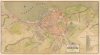

ПЛАНЪ ГОРОДА ОДЕССЫ. / Plan of the City of Odessa.
Odessa at its cultural and economic zenith.
- Digital Map Information
- Suitable for large format printing
- File Size: 36.07 MB
- File Type: ZIP / TIFF
- ICC color profile embedded
- Delivered instantly via download link
Odessa at its cultural and economic zenith.
This is a 1912 chromolithograph map of Odessa, Ukraine, capturing the city at its economic and cultural zenith. It was produced for the Imperial Society of Agriculture of Southern Russia (Императорское Общество Сельского Хозяйства Южной России) by the Odessa lithographer A. Til and Company. At the time, Odessa was one of the largest cities in the Russian Empire, often called the 'Southern Capital of Russia' for its economic, military, and cultural significance. The map records the breakneck pace of development Odessa underwent in the early 20th century, when it was Russia's largest port and home to its most active stock exchange. It was also, as this map reflects, an extremely diverse city, home to large Russian, Jewish, Ukrainian, Greek, and Armenian communities.A Closer Look
The map is oriented to the east with the Black Sea at the top and Odessa's urban zone at center. Streets, trams, railroads, parks, civic buildings, and more are meticulously labeled. In newer areas, individual lots are segmented out. The port is also highlighted in detail - emphasizing Odessa's significance as the home of Imperial Russia's Black Sea Fleet. Beyond the peach-shaded center, the cartographer reveals a host of new developments, many seemingly dropped haphazardly with street grids out of sync with the broader urban plan - likely indicative of a lack of centralized urban planning.Imperial Society of Agriculture of Southern Russia
The map's sponsor organization, the Imperial Society of Agriculture of Southern Russia (Императорское Общество Сельского Хозяйства Южной России), was one of the most prominent scientific and agricultural institutions of the Russian Empire. Established in Odessa in 1828 under imperial patronage, the society's mission was to advance agricultural knowledge, improve farming practices, and promote scientific innovation, particularly in present-day Ukraine. It organized agricultural exhibitions, published research, and operated experimental fields (опытные поля) for testing crops and modern techniques. The society also served as a hub connecting landowners, agronomists, and scientists, contributing to the modernization of Russian agriculture. By the late 19th and early 20th centuries, it had become a symbol of the empire's effort to apply European agricultural science to its vast southern territories.Chromolithography
Chromolithography, sometimes called oleography, is a color lithographic technique developed in the mid-19th century. The process uses multiple lithographic stones, one for each color, to yield a rich composite effect. Generally, a chromolithograph begins with a black basecoat upon which subsequent colors are layered. Some chromolithographs used 30 or more separate lithographic stones to achieve the desired effect. Chromolithograph color can be blended for even more dramatic results. The process became extremely popular in the late 19th and early 20th centuries when it emerged as the dominant method of color printing. The vivid color chromolithography made it exceptionally effective for advertising and propaganda.Publication History and Census
This map was prepared by the Imperial Society of Agriculture of Southern Russia (Императорское Общество Сельского Хозяйства Южной России) and printed via chromolithograph by V. Til of Odessa, in 1913. We note variations of this map as early as 1894 and as late as 1919. Throughout this period, we see multiple publishers and printing methods, many of which are likely piracies. We see no other examples of this edition recorded in any institutional catalog.Cartographer
Vilgelm Til (Wilhelm Til, Вильгельм Тиль, В. Тиль и К°; fl. c 1859 - 1919) was a prominent printer based in Odessa, Ukraine, at the time a major port city under the Russian Empire. Til is best known for printing chromolithographic religious icons, but also issue maps, advertising, and other decorative prints. Through the early 20th century, the firm was based at 15 Troitskaya Street, at the corner of Remeslennaya Street, Odessa. In the early 20th century, likely around 1912, the firm was taken over by Vilgelm's sons, Oskar Wilhelmovich Til (Оскар) and Richard Till (Рихард). The younger Till was also treasurer of the Fedorov Society for the Mutual Assistance of Printing and Lithographer Workers (Фёдоровское общество взаимопомощи типографских и литографских рабочих), a professional mutual-aid organization active in Odessa until about 1914. The firm continued to operate until the Russian Revolution (1917 - 1923). We see not Til publications postdating 1919. Further Details...
Condition
Good. Map has been laid down on archival tissue for stabilization. Several areas of loss, primarily at old fold intersections, most repaired with infill.