This item has been sold, but you can get on the Waitlist to be notified if another example becomes available, or purchase a digital scan.
1909 Love / Woodward-Tiernan Railroad Map of Oklahoma w/ Oil Wells and Pipelines
OklahomaRailroads-woodwardtiernan-1909$750.00


Title
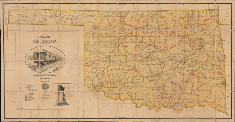
Railroad Map of Oklahoma.
1909 (dated) 27.75 x 53.5 in (70.485 x 135.89 cm) 1 : 633600
1909 (dated) 27.75 x 53.5 in (70.485 x 135.89 cm) 1 : 633600
Description
This is a 1909 Woodward and Tiernan large-format folding railroad map of the State of Oklahoma at the peak of the Tulsa Oil Boom and just two years after Oklahoma became the 46th state. This was the era of Tulsa's 'Black Wall Street,' an unprecedented explosion of oil-driven African-American wealth centered around Tulsa. The map provides granular detail of the state's rail and oil infrastructure during this heady period.
Oil and gas pipelines (centered around Tulsa), electrical lines, cotton compresses and factories, and flouring mills are also indicated. Illustrations of a passenger train and an oil well below the title reinforce the main information on the map.
The rights of Native Americans were often of secondary consideration in the scramble to exploit natural resources for profit. Even where Indians had relatively strong legal claims to their land and its resources (as with the Osage Nation) and consequently did acquire significant wealth in the early 20th century, legal requirements (such as that requiring a White 'guardian' for legal proceedings for all full and half-blood Indians) and the schemes of unscrupulous malefactors often led to Indians losing their legal rights over oil-rich lands through chicanery. In the most extreme case - the Osage Indian Murders of the 1920s (retold in the 2017 book and 2023 film Killers of the Flower Moon) - a conspiracy was hatched by powerful rancher and political boss William Hale to simply kill dozens of Indians with legal claims to oil-producing lands and maneuver to gain control of their property. The uncovering of the Osage Indian Murders led to Congress scrapping the guardianship requirement and forbidding non-Osage from inheriting Osage-owned lands.
A Closer Look
The state of Oklahoma is displayed with county lines, cities, and towns indicated. A complex network of 13 color-coded rail lines crisscross the state. These include national railroad lines like the 'Atchison, Topeka, and Santa Fe Railroad' and the 'Chicago, Rock Island, and Pacific Railroad' to local operations like the 7.8-mile 'Poteau Valley Railroad'. Rail stations of several classes are noted throughout, with distances between stations recorded in black and between major stations or interchanges (principal points) noted in red.Oil and gas pipelines (centered around Tulsa), electrical lines, cotton compresses and factories, and flouring mills are also indicated. Illustrations of a passenger train and an oil well below the title reinforce the main information on the map.
The Tulsa Oil Boom and Black Wall Street
During the Tulsa Oil Boom of the early 20th century, vast wealth flowed into Oklahoma, transforming Tulsa into a booming economic hub - and within it, the Greenwood District, known as Black Wall Street, emerged as one of the most prosperous African American communities in the United States. During Reconstruction, which followed the American Civil War (1861 - 1865), the U.S. government enforced stricter terms the slave-owning American Indian nations that had allied with the Confederacy than on Southern States. Particularly in Oklahoma, American Indian nations were compelled to give their freed slaves (about 14% of the population of tribal lands) shares in communal lands and tribal rights. By the end of Reconstruction, Black tribal Freedmen held millions of acres in common with other tribal members and large individual allotments. While many of these allotments comprised the tribes' rockiest, driest, and most inhospitable land, such lands were exactly where, decades later, rich oil reserves were discovered. Black entrepreneurs subsequently capitalized on oil-related opportunities to reinvest in their communities. In particular, the Greenwood neighborhood of Tulsa became a thriving center of Black-owned businesses, banks, newspapers, and cultural life - the Black Wall Street. In 1921, Black Wall Street was tragically destroyed during the Tulsa Race Massacre, when a white mob, fueled by resentment and false accusations, attacked the district - killing hundreds, burning homes and businesses, and erasing decades of Black success. The Tulsa Oil Boom brought immense wealth, but also underscored the deep racial inequities of the time, with Black Wall Street representing both the heights of Black economic achievement and the devastating consequences of systemic racism.Roads, Rails, and Oil
This map was produced at the dawn of the automotive age when railroads were still the main means of intercity travel and freight transport. As the state was being formed, it was also undergoing a massive oil boom that continues to define its economy today. This was a major reason for the density of rail infrastructure seen here. Outsiders rushed in, first in land grabs in the late 19th century and later as economic migrants to work in the oil and gas industry. Boomtowns sprang up overnight (and could disappear just as quickly once resources were exhausted). Tulsa, in particular, became the financial and administrative center of the oil boom, 'the oil capital of the world,' growing from a town to a teeming metropolis in a matter of years at the start of the 20th century.The rights of Native Americans were often of secondary consideration in the scramble to exploit natural resources for profit. Even where Indians had relatively strong legal claims to their land and its resources (as with the Osage Nation) and consequently did acquire significant wealth in the early 20th century, legal requirements (such as that requiring a White 'guardian' for legal proceedings for all full and half-blood Indians) and the schemes of unscrupulous malefactors often led to Indians losing their legal rights over oil-rich lands through chicanery. In the most extreme case - the Osage Indian Murders of the 1920s (retold in the 2017 book and 2023 film Killers of the Flower Moon) - a conspiracy was hatched by powerful rancher and political boss William Hale to simply kill dozens of Indians with legal claims to oil-producing lands and maneuver to gain control of their property. The uncovering of the Osage Indian Murders led to Congress scrapping the guardianship requirement and forbidding non-Osage from inheriting Osage-owned lands.
Publication History and Census
This map was prepared in 1909 by the Oklahoma Corporation Commission and printed by Woodard and Tiernan. It is the first edition, followed by multiple subsequent editions into the 1970s, though with decreasing regularity. This first edition is especially scarce, with cataloged examples only held by Yale University, the University of Oklahoma, the University of Missouri-St. Louis, and the David Rumsey Historical Map Collection.Cartographer
William Henry Woodward (December 11, 1834 - November 30, 1904) was an English-American printer and publisher based in St. Louis. Woodward was born in Hereford, England. He moved with his parents to the United States in 1841-2, when his father had a disagreement with the Church of England, moved to New Jersey, and was ordained an Episcopal Minister. The family moved between churches, in Pennsylvania, Michigan, Wisconsin (1849 - 1851), before finally, in 1851-2, settling permanently in St. Louis. W. H. remained in Madison, where from 1849 to 1852, he apprenticed in the printing trade under Col. David Atwood, publisher of the Wisconsin Statesman. In St. Louis, he began his work in the printing trade at the Missouri Republican, at the time the main regional paper. He attained some success and leverage his savings to purchase the printing concern of George H. Hanson. Woodward establishment quickly gained reputation for solid work promptly delivered. During the Civil War, Woodward was recruited into the Missouri Home Guard and saw active service under General. E.C. Pike. In 1868 James Tiernan (1838 - September 16, 1886), a former colleague from the Missouri Republican joined the firm, after which the imprint changed to 'Woodward and Tiernan.' The business also moved to the intersection of Third and Pine. In 1872, William B. Hale also joined the partnership, and the imprint was changed again, this time to 'Woodward, Tiernan and Hale.' The business moved again, this time to the intersection of Second and Locust. Hale retired in 1882, causing the firm's imprint to revert to 'Woodward and Tiernan.' Tiernan passed away in 1886, just as the firm was preparing to move into even large quarters ate 309-315 North Third Street. Woodward acquired Tiernan's shares and reorganized the firm as the 'Woodward and Tiernan Stock Company.' Under Woodward's management the company grew to become a major concern employing some 800 people and occupying several factories. Woodward died of a heart attack at the St. Louis Club in November of 1904. More by this mapmaker...
Condition
Very good. Dissected and mounted on linen. Soiling at left.
References
Rumsey 4294.002. OCLC 47976655. Yale Beinicke BEIN Art Storage 1003.