
1994 Arabic-Language National Survey Map of Oman

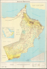
سلطنة عمان / [Sultanate of Oman]. / المجموعة: عمان متنوعة ٠٦, الطبعة: هـ و م ٠٤ / [Series: Oman Miscellaneous 06, Edition: National Survey Authority 04].
Transformation of Oman.
Transformation of Oman.
This is a large-format 1994 map of the Sultanate of Oman prepared by the country's National Survey Authority. It depicts the country during a period of rapid change and modernization under Sultan Qaboos, who would go on to lead the Sultanate for 50 years and fundamentally transform it. The map's production reflects these developments, as the National Survey Authority had existed for only a decade when it was issued.A Closer Look
This map provides a comprehensive overview of the topography and infrastructure of the Sultanate of Oman. Much of the focus is on roads, explained in the legend at the bottom-right, which range from paved highways to unpaved but graded tracks. Distances between larger settlements are marked. The development of a modern, national road network was a hallmark project of Sultan Qaboos (discussed more below), who ruled the country for fifty years between the 1970s and 2010s.Aside from road infrastructure, information is provided on terrain, settlements, airports, and historical fortifications. A table of distances appears at the bottom-right. The map uses the phrase 'Arabian Gulf' (الخليج العربي) rather than Persian Gulf at the top-left, standard on Arabic maps of the time, despite Oman's relatively open relations with Iran after 1979. Two revealing warnings advise anyone viewing the map that 'Travel inside remote border areas and certain other regions is prohibited. The inclusion of any road or unpaved/dirt track on the map does not indicate that such road or track is in a satisfactorily usable condition for motor vehicles...' and 'This map is not to be relied upon regarding political boundaries [a common disclaimer on maps of the region as many boundaries were disputed for decades]. All islands, coral reefs, rocks, shoals, sandbars, and other exposed land features separated from the mainland but lying within the territorial waters of the Sultanate—whether depicted on this map or not—form, along with the seabed, an integral part of the Sultanate of Oman.'
Sultan Qaboos and the Transformation of Oman
Sultan Qaboos bin Said al Said (r. 1970 - 2020) came to power on July 23, 1970, after deposing his father, Sultan Said bin Taimur, in a bloodless coup supported by Great Britain. At his accession, Oman was deeply isolated and economically stagnant, possessing only a few miles of paved roads, three modern schools, and two hospitals, all while actively fighting the Marxist-backed Dhofar Rebellion in the south. Sultan Qaboos immediately launched the 'Blessed Renaissance' (Al-Nahda), deploying crude oil revenues to construct national infrastructure, schools, and healthcare facilities while extending amnesty to rebel combatants.By combining targeted socio-economic development with military assistance from Britain, Iran, and Jordan, Qaboos declared the Dhofar War ended in early 1976, unifying the country for the first time in decades. Throughout the late 1970s and 1980s, Sultan Qaboos focused on state-building and establishing an independent, pragmatic foreign policy. Internationally, Oman maintained balanced relations across the Persian Gulf, co-founding the Gulf Cooperation Council (GCC) in 1981 while maintaining working ties with Iran, which enabled Oman to act as a neutral diplomatic bridge during the Iran-Iraq War (1980-1988). Domestically, the government professionalized its civil and military institutions, establishing specialized technical bodies such as the National Survey Authority under the Ministry of Defence in 1984 to systematically map, survey, and organize national infrastructure.
By the early 1990s, Sultan Qaboos initiated gradual political reforms and prioritized the permanent settlement of Oman's international boundaries, a longstanding and thorny issue with Oman's neighbors. Following the 1990-1991 Gulf War, he created the Consultative Council in 1991 to give citizens a voice in governance and public policy, and in 1996 promulgated the Basic Statute of Oman, a constitution for the Sultanate that codified civil liberties, government structures, and executive succession mechanisms.
Publication History and Census
This map was prepared by the National Survey Authority of Oman in 1994. It is at least the second edition, though the notation at the bottom-left (NSA 04) suggests a fourth edition. In any event, the only known institutional example is a 1990 edition held by the Library of Congress.Cartographer
National Survey Authority of Oman (الهيئة الوطنية للمساحة ; c. 1984 - present), abbreviated as NSA and now known as the National Survey and Geospatial Information Authority (NSGIA), is the primary government body responsible for national mapping, geodetic control, and maintaining the geographic archives of the Sultanate. The NSA was established in October 1984 as an agency within the Ministry of Defence. It was created to centralize, standardize, and regulate all military and civilian surveying activities across Oman, replacing a patchwork of domestic and foreign military surveys (namely, those by the UK's Directorate of Military Survey and the Royal Air Force), oil company data, and departmental mapping efforts. In the years after its creation, the NSA's work has been supplemented by additional government bodies such as the National Hydrographic Office and Ministry of Housing (which manages the land cadaster). Further Details...
Condition
Very good. Wear along original fold lines. Slight loss at a few fold intersections.
References
OCLC 793695949 (1990 ed.).